Dzomi Gewog: Difference between revisions
Content deleted Content added
fix infobox: regions are obsolete. fix translation |
No edit summary |
||
| (9 intermediate revisions by 6 users not shown) | |||
| Line 1: | Line 1: | ||
{{Infobox settlement |
{{Infobox settlement |
||
|official_name |
|official_name= Dzomi Gewog |
||
|native_name= འཅོམས་མི་ |
|||
|other_name = |
|||
|settlement_type= Gewog |
|||
|native_name = |
|||
|image_skyline= |
|||
|nickname = |
|||
|imagesize= |
|||
|settlement_type =Gewog |
|||
|image_caption= |
|||
|motto = |
|||
|image_flag= |
|||
|image_skyline = |
|||
|flag_size= |
|||
|imagesize = |
|||
|image_seal= |
|||
|image_caption = |
|||
|seal_size= |
|||
|image_flag = |
|||
|image_map= Punakha Bhutan location map.png |
|||
|flag_size = |
|||
|mapsize= 350px |
|||
|image_seal = |
|||
|subdivision_type= Country |
|||
|seal_size = |
|||
|subdivision_name= {{flag|Bhutan}} |
|||
|image_map = |
|||
|subdivision_type1= [[Districts of Bhutan|District]] |
|||
|mapsize = |
|||
|subdivision_name1= [[Punakha District]] |
|||
|map_caption = |
|||
|subdivision_type2= |
|||
|pushpin_map = |
|||
|subdivision_name2= |
|||
|pushpin_label_position =bottom |
|||
|government_footnotes= |
|||
|pushpin_mapsize= |
|||
|government_type= |
|||
|pushpin_map_caption = |
|||
|leader_title= |
|||
|subdivision_type = Country |
|||
|leader_name= |
|||
|subdivision_name ={{flag|Bhutan}} |
|||
|established_title= |
|||
|subdivision_type1 =[[Districts of Bhutan|District]] |
|||
|established_date= |
|||
|subdivision_name1 =[[Punakha District]] |
|||
|area_magnitude= |
|||
|subdivision_type2 = |
|||
|unit_pref= Metric |
|||
|subdivision_name2 = |
|||
|area_footnotes= |
|||
|government_footnotes = |
|||
|area_total_km2= |
|||
|government_type = |
|||
|area_land_km2= |
|||
|leader_title = |
|||
|population_as_of= |
|||
|leader_name = |
|||
|population_footnotes= |
|||
|established_title = |
|||
|population_note= |
|||
|established_date = |
|||
|population_total= |
|||
|area_magnitude = |
|||
|population_density_km2= |
|||
|unit_pref =Imperial |
|||
|timezone= [[Bhutan Time|BTT]] |
|||
|area_footnotes = |
|||
|utc_offset= +6 |
|||
|area_total_km2 = |
|||
|timezone_DST= |
|||
|area_land_km2 = |
|||
|utc_offset_DST= |
|||
|population_as_of = |
|||
|elevation_footnotes= |
|||
|population_footnotes = |
|||
|elevation_m= |
|||
|population_note = |
|||
|elevation_ft= |
|||
|population_total = |
|||
|postal_code_type= |
|||
|population_density_km2 = |
|||
|postal_code= |
|||
|timezone =[[Bhutan Time|BTT]] |
|||
|area_code= |
|||
|utc_offset = +6 |
|||
|footnotes= |
|||
|timezone_DST = |
|||
|utc_offset_DST = |
|||
|latd=|latm= |lats= |latNS=N |
|||
|longd=|longm=|longs=|longEW=E |
|||
|elevation_footnotes = |
|||
|elevation_m = |
|||
|elevation_ft = |
|||
|postal_code_type = |
|||
|postal_code = |
|||
|area_code = |
|||
|blank_name = |
|||
|blank_info = |
|||
|website = |
|||
|footnotes = |
|||
}} |
}} |
||
''' |
'''Dzomi Gewog''' ([[Dzongkha]]: འཅོམས་མི་) is a [[gewog]] (village block) of [[Punakha District]], [[Bhutan]].<ref>{{cite web |url= http://www.election-bhutan.org.bt/2011/finaldelimitation/Punakha.pdf |format= PDF |title= Chiwogs in Punakha |publisher= Election Commission, [[Government of Bhutan]] |year= 2011 |access-date= 2011-07-28 |archive-url= https://web.archive.org/web/20111002185158/http://www.election-bhutan.org.bt/2011/finaldelimitation/Punakha.pdf |archive-date= 2011-10-02 |url-status= dead }}</ref><ref>{{cite web|url=http://www.gnhc.gov.bt/ | title= -|publisher=Royal Government of Bhutan|access-date=December 12, 2010}}</ref> |
||
== Geography == |
|||
The gewog has an altitude ranging of 1200 meters to 2400 meters above sea level. It borders [[Shengana gewog|Shenghana]] and [[Lingmukha Gewog|Lingmukha]] Gewogs and has an area of about 22 km2.<ref>http://www.punakha.gov.bt/en/gewogs/dzomi</ref> |
|||
== Population and Demographics == |
|||
Dzomi has a population of 1350 people in 257 households. <ref>http://www.punakha.gov.bt/en/gewogs/dzomi</ref> |
|||
== Institutions == |
|||
Institutions in Dzomi Gewog include a primary school near the town of [[Khuruthang]] and a [[Khuruthang Middle Secondary School|secondary school]]. <ref>http://www.punakha.gov.bt/en/gewogs/dzomi</ref> |
|||
== Agriculture == |
|||
Dzomi has a small agricultural industry that grows wheat, paddy rice, and mustard. There is limited forest coverage, leading to a lack of sufficient building materials.<ref>http://www.punakha.gov.bt/en/gewogs/dzomi</ref> |
|||
==References== |
==References== |
||
{{Reflist}} |
{{Reflist}} |
||
{{Gewogs of Bhutan}} |
{{Gewogs of Bhutan}} |
||
{{Authority control}} |
|||
[[Category:Gewogs of Bhutan]] |
[[Category:Gewogs of Bhutan]] |
||
[[Category:Punakha District]] |
[[Category:Punakha District]] |
||
{{Bhutan-geo-stub}} |
{{Bhutan-geo-stub}} |
||
{{coord missing|Bhutan}} |
{{coord missing|Bhutan}} |
||
Latest revision as of 21:52, 12 March 2024
Dzomi Gewog
འཅོམས་མི་ | |
|---|---|
Gewog | |
 | |
| Country | |
| District | Punakha District |
| Time zone | UTC+6 (BTT) |
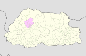
Dzomi Gewog (Dzongkha: འཅོམས་མི་) is a gewog (village block) of Punakha District, Bhutan.[1][2]
Geography[edit]
The gewog has an altitude ranging of 1200 meters to 2400 meters above sea level. It borders Shenghana and Lingmukha Gewogs and has an area of about 22 km2.[3]
Population and Demographics[edit]
Dzomi has a population of 1350 people in 257 households. [4]
Institutions[edit]
Institutions in Dzomi Gewog include a primary school near the town of Khuruthang and a secondary school. [5]
Agriculture[edit]
Dzomi has a small agricultural industry that grows wheat, paddy rice, and mustard. There is limited forest coverage, leading to a lack of sufficient building materials.[6]
References[edit]
- ^ "Chiwogs in Punakha" (PDF). Election Commission, Government of Bhutan. 2011. Archived from the original (PDF) on 2011-10-02. Retrieved 2011-07-28.
- ^ "-". Royal Government of Bhutan. Retrieved December 12, 2010.
- ^ http://www.punakha.gov.bt/en/gewogs/dzomi
- ^ http://www.punakha.gov.bt/en/gewogs/dzomi
- ^ http://www.punakha.gov.bt/en/gewogs/dzomi
- ^ http://www.punakha.gov.bt/en/gewogs/dzomi
