Petőfibánya: Difference between revisions
m Substing templates: {{KSH code}}. See User:AnomieBOT/docs/TemplateSubster for info. |
m →History: sp, ce |
||
| (16 intermediate revisions by 11 users not shown) | |||
| Line 1: | Line 1: | ||
{{Infobox settlement |
{{Infobox settlement |
||
| name = Petőfibánya |
|||
| |
| settlement_type = Village |
||
| |
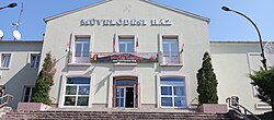
| image_skyline = Petőfibánya, Cultural Centre.jpg |
||
| |
| image_caption = Cultural Center |
||
| |
| image_flag = |
||
| image_shield = HUN Petőfibánya Címer.svg |
|||
<!-- Political information -->| subdivision_type = Country |
|||
| |
| map_alt = |
||
| |
| pushpin_map = Hungary |
||
| pushpin_map_caption = Location in Hungary |
|||
| subdivision_name1 = [[{{Hungarian county region|Heves}}]] |
|||
| coordinates = {{coord|47|45|57|N|19|42|07|E|display=inline}} |
|||
| ⚫ | |||
| subdivision_type = [[List of sovereign states|Country]] |
|||
| ⚫ | |||
| subdivision_name = {{HUN}} |
|||
| subdivision_type3 = [[Subregions of Hungary|Subregion]] |
|||
| |
| subdivision_type1 = [[Counties of Hungary|County]] |
||
| |
| subdivision_name1 = [[Heves County|Heves]] |
||
| ⚫ | |||
| subdivision_name6 = {{Hungarian settlement rank name|[[község]]}} |
|||
| ⚫ | |||
<!-- Geographical information -->| area_total_km2 = 11.11 |
|||
| |
| established_title = First mentioned |
||
| established_date = 1942 |
|||
| area_footnotes = <ref name="ksh_cite_area">[http://www.ksh.hu/apps/!cp.hnt2.telep?nn=33686 Petőfibánya] at the [[Hungarian Central Statistical Office]] (Hungarian). </ref> |
|||
| |
| founder = |
||
| leader_party = Independent |
|||
<!-- Demographical information -->| postal_code = 3023 |
|||
| |
| leader_title = Mayor |
||
| |
| leader_name = Péter Juhász |
||
| |
| unit_pref = Metric<!-- or US or UK --> |
||
| |
| area_total_km2 = 11.11 |
||
| |
| elevation_footnotes = |
||
| |
| elevation_m = |
||
| |
| population_total = 2457 |
||
| population_as_of = 2022 |
|||
| ⚫ | |||
| population_density_km2 = auto |
|||
| ⚫ | |||
| |
| timezone1 = [[Central European Time|CET]] |
||
| utc_offset1 = +1 |
|||
| population_density_urban_km2 = auto |
|||
| timezone1_DST = [[Central European Summer Time|CEST]] |
|||
| population_density_metro_km2 = auto |
|||
| utc_offset1_DST = +2 |
|||
| population_footnotes = <ref name="ksh_cite_population">[http://www.ksh.hu/apps/!cp.hnt2.telep?nn=33686 Petőfibánya] at the [[Hungarian Central Statistical Office]] (Hungarian). </ref> |
|||
| |
| postal_code_type = Postal code |
||
| |
| postal_code = 3023 |
||
| area_code_type = Area code |
|||
| area_code = 37 |
|||
| ⚫ | |||
| ⚫ | |||
}} |
}} |
||
'''Petőfibánya' |
'''Petőfibánya''' is a village in [[Heves County]], [[Hungary]], beside of the [[Zagyva]] river, under the [[Mátra]] mountain range. As of 2022 census, it has a population of 2457 (see Demographics). |
||
The village located 2.7 km from (Nr. 81) [[Hatvan–Fiľakovo railway]] line, 2.9 km from the [[Main road 21 (Hungary)|main road 21]], and 11.9 km from the [[M3 motorway (Hungary)|M3 motorway]]. The closest train station with public transport in [[Lőrinci]]. |
|||
== |
==History== |
||
At the end of the 19th century, the owner of the area was the Schossberger family, who used the area for grape production, the center of the estate was a farm called ''Pernyepuszta''. The extraction of the discovered [[lignite]] began in 1942 by the Mátravidék Coal Mines Company and an [[industrial railway]] was built from [[Lőrinci]] to the mine. The creation of miners' apartments began in 1943 around the [[Coal mining|mine]]. Mining was interrupted in the autumn of 1944, and the equipment was hidden in the mine, because of the [[Hungary in World War II|war]]. At the beginning of 1945, the apartments were once again filled with miners, and the operation of the mine started again in 1948. The settlement was named Petőfibánya (''Petőfi mine'') in 1949 after the Hungarian poet [[Sándor Petőfi]]. The mined coal was processed at the {{Interlanguage link|Mátravidék Power Plant|lt=Mátravidék Power Plant|hu|Mátravidéki Erőmű}}. A doctor's office was built after 1950, together with a dentist's office, the cultural center, sports fields, the school and houses with gardens were built. The effective work of the miners was recognized with state awards in 1959. The appearance of [[open-pit mining]] marked the end of mining in the settlement. The mine was closed in 1967, as extraction became more economical in [[Ecséd]] and [[Visonta coal mine|Visonta]], but the lignite wealth remained. However, the population did not leave the [[Mining community|mining settlement]], but remained and started [[commuting]] to other places. The settlement was officially part of [[Lőrinci]] till 1989, then forme it an independent village.<ref>{{cite web|url=http://www.petofibanya.hu/CMS/Pages/Html.aspx?Id=6A221784-5AE1-401A-8988-A9C0007D8BE7|title=History of Petőfibánya|accessdate=25 February 2024|language=hu}}</ref> |
|||
==Demographics== |
|||
Petőfibánya is situated 15 km from [[Hatvan]], in the [[Mátraalja]] microregion, among the foothills of the [[Mátra]] mountain range. The town was built by the [[Lőrinci]]-[[Rózsaszentmárton]] highway, not far from the River [[Zagyva]]. |
|||
According the 2022 census, 89.3% of the population were of Hungarian ethnicity, 0.7% were [[Ukrainians|Ukrainian]] and 10.5% were did not wish to answer. The religious distribution was as follows: 22.3% [[Catholic Church in Hungary|Roman Catholic]], 2.0% [[Reformed Church in Hungary|Calvinist]], 34.1% non-denominational, and 38.1% did not wish to answer. 2447 people live in the village and 10 in a farm.<ref name="2022 village data">{{cite web|url=https://www.ksh.hu/apps/hntr.telepules?p_lang=EN&p_id=33686|title=Petőfibánya|publisher=[[Hungarian Central Statistical Office]]|work=ksh.hu|accessdate=24 February 2024}}</ref> |
|||
Population by years:<ref>{{cite web|title=Population number, population density|website=Hungarian Central Statistical Office|url=http://www.ksh.hu/nepszamlalas/docs/tables/regional/12/12_4_1_1_1_en.xls|accessdate=2024-02-22}}</ref> |
|||
==History<ref>{{Cite web|url=http://www.petofibanya.hu/CMS/Pages/Html.aspx?Id=6a221784-5ae1-401a-8988-a9c0007d8be7|title=Petőfibánya|website=www.petofibanya.hu|access-date=2019-05-10}}</ref>== |
|||
{| class="wikitable" |
|||
|- |
|||
! Year !! 1890 !! 1900 !! 1910 !! 1920 !! 1930 !! 1941 !! 1949 |
|||
|- |
|||
| Population || 0 || 94 || 146 || 192 || 185 || 151 || 1080 |
|||
|- |
|||
! Year !! 1960 !! 1970 !! 1980 !! 1990 !! 2001 !! 2011 !! 2022 |
|||
|- |
|||
| Population || 3981 || 3718 || 3614 || 3343 || 3152 || 2809 || 2457 |
|||
|} |
|||
==Politics== |
|||
Petőfibánya is a small [[planned city]] established between 1945 and 1965. Originally there was a small settlement on the site called Pernyepuszta. A coal mine was established in 1942 and exploitation of the local [[lignite]] reserves began in October 1945. The settlement was renamed to Pernyebánya that year, and Petőfibánya in 1948 (''bánya'' means "mine" in Hungarian). |
|||
''Mayors since 1990'': |
|||
* 1990–1992: László Fekete (independent)<ref>{{cite web|url=https://static.valasztas.hu/letoltesek/valasztasi_eredmenyek_1990-2019.tar|title=Petőfibánya settlement election results|accessdate=2024-02-25|publisher=National Election Office|format=txt|language=hu}}</ref> |
|||
The mine was operated by the Petőfi Mining Company that built a power plant in nearby [[Lőrinci]]. Petőfibánya was part of [[Lőrinci]] until 1989 when it became an independent municipality. The mining company also established a mining machine plant in Petőfibánya. Other industrial activities appeared later. The town was given its present name after the state owned company which bore the name of [[Sándor Petőfi]], the national poet of Hungarians. |
|||
* 1992–1994: István Papp (independent)<ref>{{cite web|url=https://library.hungaricana.hu/hu/view/HevesMegyeiNepujsag_1992_01/?pg=208&layout=s&query=id%C5%91k%C3%B6zi|title=Petőfibánya settlement election results|accessdate=2024-02-25|publisher=Heves County Newspaper|language=hu}}</ref> |
|||
* 1994–2010: László Fekete (independent)<ref>{{cite web|url=https://valtor.valasztas.hu/valtort/jsp/teljkv.jsp?EA=11&MAZ=10&TAZ=085&W=4|title=Petőfibánya settlement election results|accessdate=2024-02-25|publisher=National Election Office|language=hu}}</ref><ref>{{cite web|url=https://valtor.valasztas.hu/valtort/jsp/teljkv.jsp?EA=16&MAZ=10&TAZ=085&W=4|title=Petőfibánya settlement election results|accessdate=2024-02-25|publisher=National Election Office|language=hu}}</ref><ref>{{cite web|url=https://valtor.valasztas.hu/valtort/jsp/teljkv.jsp?EA=19&MAZ=10&TAZ=085&W=4|title=Petőfibánya settlement election results|accessdate=2024-02-25|publisher=National Election Office|language=hu}}</ref><ref>{{cite web|url=https://valtor.valasztas.hu/valtort/jsp/teljkv.jsp?EA=25&MAZ=10&TAZ=085&W=4|title=Petőfibánya settlement election results|accessdate=2024-02-25|publisher=National Election Office|language=hu}}</ref> |
|||
In the 1950s and 1960s block houses and public buildings were erected in the typical [[Socialist realist]] style of the era. Petőfibánya never became an important industrial city because lignite mining halted in the middle of the 1960s. The development of the town came to an abrupt end. |
|||
* 2010–2019: Éva Barkóczy, [[Hungarian names#Married names|Mrs. Juhász]] (independent)<ref>{{cite web|url=https://static.valasztas.hu/dyn/ov10/outroot/onktjk3/10/tjk10085.htm|title=Petőfibánya settlement election results|accessdate=2024-02-25|publisher=National Election Office|language=hu}}</ref><ref>{{cite web|url=https://static.valasztas.hu/dyn/onk14/szavossz/hu/M10/T085/tjk.html|title=Petőfibánya settlement election results|accessdate=2024-02-25|publisher=National Election Office|language=hu}}</ref> |
|||
* 2019–: Péter Juhász (independent)<ref>{{cite web|url=https://www.valasztas.hu/telepules-adatlap_onk2019?_onknavigacio_WAR_nvinvrportlet_formDate=32503680000000&p_p_id=onknavigacio_WAR_nvinvrportlet&p_p_lifecycle=1&p_p_state=normal&p_p_mode=view&_onknavigacio_WAR_nvinvrportlet__prpVlId=294&_onknavigacio_WAR_nvinvrportlet__prpVltId=687&_onknavigacio_WAR_nvinvrportlet__prpMegyeKod=10&_onknavigacio_WAR_nvinvrportlet__prpTelepulesKod=085&_onknavigacio_WAR_nvinvrportlet_settlement=Pet%C5%91fib%C3%A1nya|title=Petőfibánya settlement election results|accessdate=2024-02-25|publisher=National Election Office|language=hu}}</ref> |
|||
The economic consequences of the 1989 change hit Petőfibánya hard. In the 1990s unemployment was more than 30 percent and many people left the town. Today Petőfibánya is a quiet backwater and a strange "[[open-air museum]]" of the 1950s [[urban planning]] policies. |
|||
==References== |
==References== |
||
{{reflist}} |
{{reflist}} |
||
{{Hatvan District}} |
|||
{{Heves}} |
{{Heves}} |
||
{{authority control}} |
|||
{{coord|47|46|N|19|43|E|region:HU_type:city_source:GNS-enwiki|display=title}} |
|||
{{DEFAULTSORT:Petofibanya}} |
{{DEFAULTSORT:Petofibanya}} |
||
[[Category:Populated places in Heves County]] |
[[Category:Populated places in Heves County]] |
||
[[Category:Socialist planned cities]] |
[[Category:Socialist planned cities]] |
||
[[Category:Planned |
[[Category:Planned communities in Hungary]] |
||
{{Heves-geo-stub}} |
|||
Latest revision as of 17:40, 13 April 2024
Petőfibánya | |
|---|---|
Village | |
 Cultural Center | |
| Coordinates: 47°45′57″N 19°42′07″E / 47.76583°N 19.70194°E | |
| Country | |
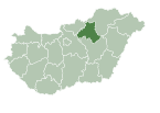
| County | Heves |
| District | Hatvan |
| First mentioned | 1942 |
| Government | |
| • Mayor | Péter Juhász (Ind.) |
| Area | |
| • Total | 11.11 km2 (4.29 sq mi) |
| Population (2022) | |
| • Total | 2,457 |
| • Density | 220/km2 (570/sq mi) |
| Time zone | UTC+1 (CET) |
| • Summer (DST) | UTC+2 (CEST) |
| Postal code | 3023 |
| Area code | 37 |
| Website | www.petofibanya.hu |
Petőfibánya is a village in Heves County, Hungary, beside of the Zagyva river, under the Mátra mountain range. As of 2022 census, it has a population of 2457 (see Demographics). The village located 2.7 km from (Nr. 81) Hatvan–Fiľakovo railway line, 2.9 km from the main road 21, and 11.9 km from the M3 motorway. The closest train station with public transport in Lőrinci.
History[edit]
At the end of the 19th century, the owner of the area was the Schossberger family, who used the area for grape production, the center of the estate was a farm called Pernyepuszta. The extraction of the discovered lignite began in 1942 by the Mátravidék Coal Mines Company and an industrial railway was built from Lőrinci to the mine. The creation of miners' apartments began in 1943 around the mine. Mining was interrupted in the autumn of 1944, and the equipment was hidden in the mine, because of the war. At the beginning of 1945, the apartments were once again filled with miners, and the operation of the mine started again in 1948. The settlement was named Petőfibánya (Petőfi mine) in 1949 after the Hungarian poet Sándor Petőfi. The mined coal was processed at the Mátravidék Power Plant. A doctor's office was built after 1950, together with a dentist's office, the cultural center, sports fields, the school and houses with gardens were built. The effective work of the miners was recognized with state awards in 1959. The appearance of open-pit mining marked the end of mining in the settlement. The mine was closed in 1967, as extraction became more economical in Ecséd and Visonta, but the lignite wealth remained. However, the population did not leave the mining settlement, but remained and started commuting to other places. The settlement was officially part of Lőrinci till 1989, then forme it an independent village.[1]
Demographics[edit]
According the 2022 census, 89.3% of the population were of Hungarian ethnicity, 0.7% were Ukrainian and 10.5% were did not wish to answer. The religious distribution was as follows: 22.3% Roman Catholic, 2.0% Calvinist, 34.1% non-denominational, and 38.1% did not wish to answer. 2447 people live in the village and 10 in a farm.[2]
Population by years:[3]
| Year | 1890 | 1900 | 1910 | 1920 | 1930 | 1941 | 1949 |
|---|---|---|---|---|---|---|---|
| Population | 0 | 94 | 146 | 192 | 185 | 151 | 1080 |
| Year | 1960 | 1970 | 1980 | 1990 | 2001 | 2011 | 2022 |
| Population | 3981 | 3718 | 3614 | 3343 | 3152 | 2809 | 2457 |
Politics[edit]
Mayors since 1990:
- 1990–1992: László Fekete (independent)[4]
- 1992–1994: István Papp (independent)[5]
- 1994–2010: László Fekete (independent)[6][7][8][9]
- 2010–2019: Éva Barkóczy, Mrs. Juhász (independent)[10][11]
- 2019–: Péter Juhász (independent)[12]
References[edit]
- ^ "History of Petőfibánya" (in Hungarian). Retrieved 25 February 2024.
- ^ "Petőfibánya". ksh.hu. Hungarian Central Statistical Office. Retrieved 24 February 2024.
- ^ "Population number, population density". Hungarian Central Statistical Office. Retrieved 2024-02-22.
- ^ "Petőfibánya settlement election results" (txt) (in Hungarian). National Election Office. Retrieved 2024-02-25.
- ^ "Petőfibánya settlement election results" (in Hungarian). Heves County Newspaper. Retrieved 2024-02-25.
- ^ "Petőfibánya settlement election results" (in Hungarian). National Election Office. Retrieved 2024-02-25.
- ^ "Petőfibánya settlement election results" (in Hungarian). National Election Office. Retrieved 2024-02-25.
- ^ "Petőfibánya settlement election results" (in Hungarian). National Election Office. Retrieved 2024-02-25.
- ^ "Petőfibánya settlement election results" (in Hungarian). National Election Office. Retrieved 2024-02-25.
- ^ "Petőfibánya settlement election results" (in Hungarian). National Election Office. Retrieved 2024-02-25.
- ^ "Petőfibánya settlement election results" (in Hungarian). National Election Office. Retrieved 2024-02-25.
- ^ "Petőfibánya settlement election results" (in Hungarian). National Election Office. Retrieved 2024-02-25.


