
Dettah: Difference between revisions
Updated |
JJMC89 bot (talk | contribs) Removed WP:NFCC violation(s). No valid non-free use rationale for this page. See WP:NFC#Implementation. Questions? Ask here. |
||
| (44 intermediate revisions by 19 users not shown) | |||
| Line 1: | Line 1: | ||
{{use Canadian English|date=March 2019}} |
|||
{{Infobox settlement |
{{Infobox settlement |
||
| name = Dettah |
| name = Dettah |
||
| native_name = |
| native_name = Tʼèɂehdaà |
||
| native_name_lang = Wíílíídeh |
|||
| other_name = |
|||
| settlement_type = Yellowknives Dene First Nation (Dettah) |
| settlement_type = Yellowknives Dene First Nation (Dettah) |
||
| motto = |
| motto = |
||
| Line 8: | Line 9: | ||
| imagesize = |
| imagesize = |
||
| image_caption = |
| image_caption = |
||
| image_flag = |
| image_flag = |
||
| flag_size = |
| flag_size = |
||
| image_seal = |
| image_seal = |
||
| Line 14: | Line 15: | ||
| image_shield = |
| image_shield = |
||
| shield_size = |
| shield_size = |
||
| pushpin_map = Canada Northwest Territories |
| pushpin_map = Canada Northwest Territories#Canada |
||
| subdivision_type = |
| subdivision_type = Country |
||
| subdivision_name = |
| subdivision_name = Canada |
||
| subdivision_type1 = [[Provinces and territories of Canada|Territory]] |
| subdivision_type1 = [[Provinces and territories of Canada|Territory]] |
||
| subdivision_name1 = [[Northwest Territories]] |
| subdivision_name1 = [[Northwest Territories]] |
||
| subdivision_type2 = [[ |
| subdivision_type2 = [[List of regions of the Northwest Territories|Region]] |
||
| subdivision_name2 = [[North Slave Region]] |
| subdivision_name2 = [[North Slave Region]] |
||
| subdivision_type3 = [[Electoral district (Canada)|Territorial electoral district]] |
| subdivision_type3 = [[Electoral district (Canada)|Territorial electoral district]] |
||
| Line 26: | Line 27: | ||
| subdivision_name4 = [[Region 6, Northwest Territories|Region 6]] |
| subdivision_name4 = [[Region 6, Northwest Territories|Region 6]] |
||
| leader_title = Chief |
| leader_title = Chief |
||
| leader_name = |
| leader_name = Ernest Betsina |
||
| leader_title1 = |
| leader_title1 = Counilors |
||
| leader_name1 = Anastassia Judas, Peter Crookedhand, Mary Rose Sundberg, Rosanna Sangris, & Liza Charlo-Pieper |
|||
| leader_name1 = Michael Cheeks |
|||
| leader_title2 = [[Legislative Assembly of the Northwest Territories|MLA]] |
| leader_title2 = [[Legislative Assembly of the Northwest Territories|MLA]] |
||
| leader_name2 = [[ |
| leader_name2 = [[Richard Edjericon]] |
||
| established_title = |
| established_title = |
||
| established_date = |
| established_date = |
||
| area_footnotes = <ref name= |
| area_footnotes = <ref name=2021census/> |
||
| area_land_km2 = 1. |
| area_land_km2 = 1.12 |
||
| elevation_m = 179 |
| elevation_m = 179 |
||
| coordinates = {{coord|62|24| |
| coordinates = {{coord|62|24|40|N|114|18|30|W|type:city_scale:10000_region:CA-NT|notes=<ref>{{cite cgndb|id=LDAWW|name=Dettah}}</ref>|display=inline,title}} |
||
| population_as_of = |
| population_as_of = 2021 |
||
| population_footnotes = <ref name= |
| population_footnotes = <ref name=2021census/> |
||
| population_total = |
| population_total = 192 |
||
| population_density_km2 = |
| population_density_km2 = 171.9 |
||
| timezone = Mountain |
| timezone = [[Mountain Time Zone|MST]] |
||
| utc_offset = |
| utc_offset = −07:00 |
||
| timezone_DST = MDT |
| timezone_DST = MDT |
||
| utc_offset_DST = |
| utc_offset_DST = −06:00 |
||
| postal_code_type = [[Canadian Postal code]] |
| postal_code_type = [[Canadian Postal code]] |
||
| postal_code = [[List of X postal codes of Canada|X1A]] |
| postal_code = [[List of X postal codes of Canada|X1A]] |
||
| Line 50: | Line 51: | ||
| blank_name = [[Telephone exchanges]] |
| blank_name = [[Telephone exchanges]] |
||
| blank_info = 444 445 446 669 765 766 873 920 |
| blank_info = 444 445 446 669 765 766 873 920 |
||
| footnotes = Sources:<br>Department of Municipal and Community Affairs,<ref name="CGDL">{{MACANT|dettah|Dettah|2017-10-29}}</ref><br>Prince of Wales Northern Heritage Centre,<ref name="pwhc">{{cite web |url= http://www.pwnhc.ca/cultural-places/geographic-names/community-names/#4/65.98/-119.97 |title= Northwest Territories Official Community Names and Pronunciation Guide |website= [[Prince of Wales Northern Heritage Centre]] |publisher= Education, Culture and Employment, Government of the Northwest Territories |location= Yellowknife |archive-url= https://web.archive.org/web/20160113110003/http://www.pwnhc.ca/cultural-places/geographic-names/community-names/ |archive-date= 2016-01-13 | |
| footnotes = Sources:<br>Department of Municipal and Community Affairs,<ref name="CGDL">{{MACANT|dettah|Dettah|2017-10-29}}</ref><br>Prince of Wales Northern Heritage Centre,<ref name="pwhc">{{cite web |url= http://www.pwnhc.ca/cultural-places/geographic-names/community-names/#4/65.98/-119.97 |title= Northwest Territories Official Community Names and Pronunciation Guide |website= [[Prince of Wales Northern Heritage Centre]] |publisher= Education, Culture and Employment, Government of the Northwest Territories |location= Yellowknife |archive-url= https://web.archive.org/web/20160113110003/http://www.pwnhc.ca/cultural-places/geographic-names/community-names/ |archive-date= 2016-01-13 |url-status= live |access-date= 2016-01-13}}</ref><br>Canada Flight Supplement<ref>{{CFS}}</ref> |
||
}} |
}} |
||
'''Dettah'''{{Pronunciation |
'''Dettah''',{{Pronunciation needed|date=March 2024}} sometimes spelled incorrectly as ''Detah'',<ref>[https://www.cbc.ca/news/canada/north/we-ve-spelled-this-n-w-t-community-s-name-wrong-for-almost-50-years-1.5333769 We've spelled this N.W.T. community's name wrong for almost 50 years]</ref> is a [[First Nations in Canada|First Nations]]<ref>[http://www.maca.gov.nt.ca/resources/Differences_in_Comm_Govt_Structure.pdf Differences in Community Government Structures]</ref> community in the [[North Slave Region]] of the [[Northwest Territories]], Canada. Located just southeast of the capital of [[Yellowknife]], it is a {{convert|6.5|km|abbr=on}} drive from that city by [[ice road]] across the north arm of [[Great Slave Lake]] in winter or a {{convert|27|km|abbr=on}} drive via the [[Ingraham Trail]], year-round. The name T'é?ehdaá means 'Burnt Point' in the Wíílíídeh dialect and was simplified to Dettah when non-indigenous people couldnʼt pronounce it. The place was a common fishing spot for the Tetsǫ́tʼine ([[Yellowknives]]) people and is home to nearly 200 indigenous people. |
||
== Demographics == |
== Demographics == |
||
In the [[2021 Canadian census]] conducted by [[Statistics Canada]], Dettah recorded a population of 192 living in 79 of its 85 total private dwellings, a change of {{percentage|{{#expr:192-219}}|219|1}} from its 2016 population of 219. With a land area of {{cvt|1.12|km2}}, it had a population density of {{Pop density|192|1.12|km2|prec=1}} in 2021.<ref name=2021census>{{cite web | url=https://www150.statcan.gc.ca/t1/tbl1/en/tv.action?pid=9810000202&geocode=A000261 | title=Population and dwelling counts: Canada, provinces and territories, and census subdivisions (municipalities), Northwest Territories | publisher=[[Statistics Canada]] | date=February 9, 2022 | accessdate=February 18, 2022}}</ref> |
|||
| ⚫ | |||
According to the [[Canada 2011 Census|2011 Census]], Dettah had a population of 210 people a decrease of 15.0% from the [[Canada 2006 Census|2006 Census]], consisting almost entirely of [[First Nations]].<ref name="2011census">[http://www12.statcan.gc.ca/census-recensement/2011/dp-pd/prof/details/page.cfm?Lang=E&Geo1=CSD&Code1=6106021&Geo2=PR&Code2=61&Data=Count&SearchText=Detah&SearchType=Begins&SearchPR=01&B1=All&GeoLevel=PR&GeoCode=6106021&TABID=1 Detah, SET Northwest Territories (Census subdivision)]</ref><ref name="comstat">[http://www.statsnwt.ca/community-data/Profile%20PDF/Detah.pdf Detah - Statistical Profile]</ref> In 2012, the Government of the Northwest Territories reported that the population was 260 with an average yearly growth rate of 1.9% from 2001.<ref name="comstat"/> |
|||
Both it and [[ |
Both it and [[Ndilǫ]] are the communities of the [[Yellowknives]]. Dettah is represented by the Yellowknives Dene First Nation (Dettah) and are part of the [[Akaitcho Territory Government]].<ref>[http://nwt-tno.inac-ainc.gc.ca/mpf/stakehld/akaitgov_e.htm Indian and Northern Affairs Canada] {{webarchive|url=https://archive.today/20070611030418/http://nwt-tno.inac-ainc.gc.ca/mpf/stakehld/akaitgov_e.htm |date=2007-06-11 }}</ref> |
||
{{Historical populations |
|||
| title = Federal census population history of Detah |
|||
| type = Canada |
|||
| align = left |
|||
| width = |
|||
| state = |
|||
| shading = |
|||
| percentages = |
|||
|1976|126 |
|||
|1981|143 |
|||
|1986|131 |
|||
|[[1991 Canadian census|1991]]|150 |
|||
|[[1996 Canadian census|1996]]|190 |
|||
|[[2001 Canadian census|2001]]|234<!--Amended by StatCan. Was 182.--> |
|||
|[[2006 Canadian census|2006]]|247 |
|||
|[[2011 Canadian census|2011]]|210 |
|||
|[[2016 Canadian census|2016]]|219 |
|||
|[[2021 Canadian census|2021]]|192 |
|||
| footnote = |
|||
| source = [[Statistics Canada]]<br/><ref name=2021census/><ref name=2016census>{{cite web | url=https://www12.statcan.gc.ca/census-recensement/2016/dp-pd/hlt-fst/pd-pl/Table.cfm?Lang=Eng&T=302&SR=1&S=86&O=A&RPP=9999&PR=61 | title=Population and dwelling counts, for Canada, provinces and territories, and census subdivisions (municipalities), 2016 and 2011 censuses – 100% data (Northwest Territories) | publisher=[[Statistics Canada]] | date=February 8, 2017 | accessdate=February 1, 2022}}</ref><ref name=1981census>{{cite web | url=https://publications.gc.ca/collections/collection_2017/statcan/CS94-905-1981.pdf | title=1981 Census of Canada: Census subdivisions in decreasing population order | publisher=[[Statistics Canada]] | date=May 1992 | accessdate=February 1, 2021}}</ref><ref name=1986census>{{cite web | url=https://publications.gc.ca/collections/collection_2013/statcan/rh-hc/CS92-101-1987.pdf | title=1986 Census: Population - Census Divisions and Census Subdivisions | publisher=[[Statistics Canada]] | date=September 1987 | accessdate=February 1, 2022}}</ref><ref name=1991census>{{cite web | url=https://publications.gc.ca/collections/collection_2013/statcan/rh-hc/CS93-304-1992.pdf | title=91 Census: Census Divisions and Census Subdivisions - Population and Dwelling Counts | publisher=[[Statistics Canada]] | date=April 1992 | accessdate=February 1, 2022}}</ref><ref name=1996census>{{cite web | url=https://publications.gc.ca/collections/collection_2012/statcan/rh-hc/CS93-357-1997.pdf | title=96 Census: A National Overview - Population and Dwelling Counts | publisher=[[Statistics Canada]] | date=April 1997 | accessdate=February 1, 2022}}</ref><ref name=2001census>{{cite web | url=https://www12.statcan.gc.ca/english/census01/products/standard/popdwell/amend.cfm | title=Population and Dwelling Count Amendments | publisher=[[Statistics Canada]] | date=July 4, 2012 | accessdate=February 1, 2022}}</ref><ref name=2006census>{{cite web | url=https://www12.statcan.gc.ca/census-recensement/2006/dp-pd/hlt/97-550/Index.cfm?TPL=P1C&Page=RETR&LANG=Eng&T=302&SR=1&S=1&O=A&RPP=9999&CMA=0&PR=61 | title=Population and dwelling counts, for Canada, provinces and territories, and census subdivisions (municipalities), 2006 and 2001 censuses - 100% data (Northwest Territories) | publisher=[[Statistics Canada]] | date=August 20, 2021 | accessdate=February 1, 2022}}</ref><ref name=2011census>{{cite web | url=https://www12.statcan.gc.ca/census-recensement/2011/dp-pd/hlt-fst/pd-pl/Table-Tableau.cfm?LANG=Eng&T=302&SR=1&S=51&O=A&RPP=9999&CMA=0&PR=61 | title=Population and dwelling counts, for Canada, provinces and territories, and census subdivisions (municipalities), 2011 and 2006 censuses (Northwest Territories) | publisher=[[Statistics Canada]] | date=July 25, 2021 | accessdate=February 1, 2022}}</ref> |
|||
}} |
|||
{{Historical populations |
|||
|align=none |
|||
|cols=2 |
|||
|title=Annual population estimates |
|||
|2001|214 |
|||
|2002|219 |
|||
|2003|214 |
|||
|2004|230 |
|||
|2005|235 |
|||
|2006|254 |
|||
|2007|250 |
|||
|2008|245 |
|||
|2009|222 |
|||
|2010|221 |
|||
|2011|216 |
|||
|2012|217 |
|||
|2013|226 |
|||
|2014|234 |
|||
|2015|244 |
|||
|2016|247 |
|||
|2017|245 |
|||
|2018|235 |
|||
|2019|234 |
|||
|footnote= Sources: NWT Bureau of Statistics (2008 - 2019),<ref>[https://www.statsnwt.ca/community-data/Profile-PDF/Dettah.pdf Dettah – Statistical Profile] at the GNWT</ref> NWT Bureau of Statistics (2001 - 2017)<ref name=brost>[https://www.statsnwt.ca/population/population-estimates/commtotals_2001-2017.xlsx Population Estimates By Community] from the GNWT</ref> |
|||
}} |
|||
==Gallery== |
|||
{{Gallery |
|||
|File:Dettah bear skin drying.jpg |
|||
|alt1= |
|||
|Bear skin drying |
|||
|File:Dettah Kateri Tekakwitha church.jpg |
|||
|alt2= |
|||
|[[Kateri Tekakwitha]] church |
|||
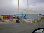
| ⚫ | |||
|alt3= |
|||
|First Nation Band Office |
|||
|File:Kaw Tay Whee School.jpg |
|||
|alt4= |
|||
|Kaw Tay Whee School |
|||
}} |
|||
==Climate== |
|||
Dettah has a [[subarctic climate]] ([[Köppen climate classification|Dfc]]) with long, severely cold winters and short but mild, sometimes warm summers. Dettah and [[Yellowknife]] experience the sunniest springs and summers out of all of Canada's cities. |
|||
Weather records are from Yellowknife Airport, approximately {{convert|9|km|abbr=on}} northwest of Dettah. |
|||
{{Yellowknife weatherbox}} |
|||
==References== |
==References== |
||
{{reflist |
{{reflist}} |
||
==Further reading== |
==Further reading== |
||
*Northwest Territories, and BHP Billiton Diamonds Inc. ''Communities and Diamonds Socio-Economic Impacts in the Communities of Behchoko, Gameti, Whati, Wekweeti, Detah, Ndilo, Lutsel |
*Northwest Territories, and BHP Billiton Diamonds Inc. ''Communities and Diamonds Socio-Economic Impacts in the Communities of Behchoko, Gameti, Whati, Wekweeti, Detah, Ndilo, Lutsel Kʼe, and Yellowknife: 2005 Annual Report of the Government of the Northwest Territories Under the BHP Billiton, Diavik and De Beers Socio-Economic Agreements''. [Yellowknife]: Govt. of the Northwest Territories, 2006. |
||
==External links== |
==External links== |
||
| ⚫ | |||
| ⚫ | |||
{{ |
{{Communities of Northwest Territories}} |
||
[[Category:Communities in the North Slave Region]] |
[[Category:Communities in the North Slave Region]] |
||
Latest revision as of 08:58, 4 April 2024
Dettah
Tʼèɂehdaà | |
|---|---|
Yellowknives Dene First Nation (Dettah) | |
 | |
 Dettah  Dettah | |
| Coordinates: 62°24′40″N 114°18′30″W / 62.41111°N 114.30833°W[1] | |
| Country | Canada |
| Territory | Northwest Territories |
| Region | North Slave Region |
| Territorial electoral district | Tu Nedhé-Wiilideh |
| Census division | Region 6 |
| Government | |
| • Chief | Ernest Betsina |
| • Counilors | Anastassia Judas, Peter Crookedhand, Mary Rose Sundberg, Rosanna Sangris, & Liza Charlo-Pieper |
| • MLA | Richard Edjericon |
| Area | |
| • Land | 1.12 km2 (0.43 sq mi) |
| Elevation | 179 m (587 ft) |
| Population (2021)[2] | |
| • Total | 192 |
| • Density | 171.9/km2 (445/sq mi) |
| Time zone | UTC−07:00 (MST) |
| • Summer (DST) | UTC−06:00 (MDT) |
| Canadian Postal code | |
| Area code | 867 |
| Telephone exchanges | 444 445 446 669 765 766 873 920 |
| Sources: Department of Municipal and Community Affairs,[3] Prince of Wales Northern Heritage Centre,[4] Canada Flight Supplement[5] | |
Dettah,[pronunciation?] sometimes spelled incorrectly as Detah,[6] is a First Nations[7] community in the North Slave Region of the Northwest Territories, Canada. Located just southeast of the capital of Yellowknife, it is a 6.5 km (4.0 mi) drive from that city by ice road across the north arm of Great Slave Lake in winter or a 27 km (17 mi) drive via the Ingraham Trail, year-round. The name T'é?ehdaá means 'Burnt Point' in the Wíílíídeh dialect and was simplified to Dettah when non-indigenous people couldnʼt pronounce it. The place was a common fishing spot for the Tetsǫ́tʼine (Yellowknives) people and is home to nearly 200 indigenous people.
Demographics[edit]
In the 2021 Canadian census conducted by Statistics Canada, Dettah recorded a population of 192 living in 79 of its 85 total private dwellings, a change of -12.3% from its 2016 population of 219. With a land area of 1.12 km2 (0.43 sq mi), it had a population density of 171.4/km2 in 2021.[2]
Both it and Ndilǫ are the communities of the Yellowknives. Dettah is represented by the Yellowknives Dene First Nation (Dettah) and are part of the Akaitcho Territory Government.[8]
| Year | Pop. | ±% |
|---|---|---|
| 1976 | 126 | — |
| 1981 | 143 | +13.5% |
| 1986 | 131 | −8.4% |
| 1991 | 150 | +14.5% |
| 1996 | 190 | +26.7% |
| 2001 | 234 | +23.2% |
| 2006 | 247 | +5.6% |
| 2011 | 210 | −15.0% |
| 2016 | 219 | +4.3% |
| 2021 | 192 | −12.3% |
| Source: Statistics Canada [2][9][10][11][12][13][14][15][16] | ||
|
| |||||||||||||||||||||||||||||||||||||||||||||||||||||||||||||||
| Sources: NWT Bureau of Statistics (2008 - 2019),[17] NWT Bureau of Statistics (2001 - 2017)[18] | ||||||||||||||||||||||||||||||||||||||||||||||||||||||||||||||||
Gallery[edit]
-
 Bear skin drying
 -
 Kateri Tekakwitha church
 -
 First Nation Band Office
 -
 Kaw Tay Whee School


Climate[edit]
Dettah has a subarctic climate (Dfc) with long, severely cold winters and short but mild, sometimes warm summers. Dettah and Yellowknife experience the sunniest springs and summers out of all of Canada's cities.
Weather records are from Yellowknife Airport, approximately 9 km (5.6 mi) northwest of Dettah.
| Climate data for Yellowknife (Yellowknife Airport) WMO ID: 71936; coordinates 62°27′46″N 114°26′25″W / 62.46278°N 114.44028°W; elevation: 205.7 m (675 ft); 1981–2010 normals, extremes 1942–present | |||||||||||||
|---|---|---|---|---|---|---|---|---|---|---|---|---|---|
| Month | Jan | Feb | Mar | Apr | May | Jun | Jul | Aug | Sep | Oct | Nov | Dec | Year |
| Record high humidex | 2.9 | 6.1 | 8.9 | 20.2 | 25.6 | 34.0 | 35.4 | 34.3 | 27.2 | 18.1 | 6.3 | 1.6 | 35.4 |
| Record high °C (°F) | 3.4 (38.1) |
6.2 (43.2) |
9.3 (48.7) |
20.4 (68.7) |
26.3 (79.3) |
31.1 (88.0) |
32.5 (90.5) |
32.6 (90.7) |
26.1 (79.0) |
19.0 (66.2) |
7.8 (46.0) |
2.8 (37.0) |
32.6 (90.7) |
| Mean maximum °C (°F) | −7.3 (18.9) |
−4.9 (23.2) |
1.6 (34.9) |
11.4 (52.5) |
20.6 (69.1) |
26.3 (79.3) |
28.4 (83.1) |
26.5 (79.7) |
19.3 (66.7) |
10.2 (50.4) |
1.1 (34.0) |
−5.0 (23.0) |
28.8 (83.8) |
| Mean daily maximum °C (°F) | −21.6 (−6.9) |
−18.1 (−0.6) |
−10.8 (12.6) |
0.4 (32.7) |
9.7 (49.5) |
18.1 (64.6) |
21.3 (70.3) |
18.1 (64.6) |
10.4 (50.7) |
0.9 (33.6) |
−10.0 (14.0) |
−17.8 (0.0) |
0.0 (32.0) |
| Daily mean °C (°F) | −25.6 (−14.1) |
−22.9 (−9.2) |
−16.8 (1.8) |
−5.3 (22.5) |
4.6 (40.3) |
13.3 (55.9) |
17.0 (62.6) |
14.2 (57.6) |
7.2 (45.0) |
−1.7 (28.9) |
−13.7 (7.3) |
−21.8 (−7.2) |
−4.3 (24.3) |
| Mean daily minimum °C (°F) | −29.5 (−21.1) |
−27.5 (−17.5) |
−22.7 (−8.9) |
−11.0 (12.2) |
−0.5 (31.1) |
8.5 (47.3) |
12.6 (54.7) |
10.2 (50.4) |
4.0 (39.2) |
−4.2 (24.4) |
−17.5 (0.5) |
−25.7 (−14.3) |
−8.6 (16.5) |
| Mean minimum °C (°F) | −42.1 (−43.8) |
−39.8 (−39.6) |
−36.3 (−33.3) |
−25.7 (−14.3) |
−9.3 (15.3) |
1.9 (35.4) |
7.7 (45.9) |
3.6 (38.5) |
−2.6 (27.3) |
−15.8 (3.6) |
−31.1 (−24.0) |
−38.5 (−37.3) |
−43.1 (−45.6) |
| Record low °C (°F) | −51.2 (−60.2) |
−51.2 (−60.2) |
−43.3 (−45.9) |
−40.6 (−41.1) |
−22.8 (−9.0) |
−4.4 (24.1) |
0.6 (33.1) |
−0.6 (30.9) |
−9.7 (14.5) |
−28.9 (−20.0) |
−44.4 (−47.9) |
−48.3 (−54.9) |
−51.2 (−60.2) |
| Record low wind chill | −64.0 | −61.0 | −56.8 | −53.2 | −31.8 | −11.2 | 0.0 | −4.8 | −16.4 | −36.3 | −54.7 | −58.9 | −64.0 |
| Average precipitation mm (inches) | 14.3 (0.56) |
14.1 (0.56) |
13.9 (0.55) |
11.3 (0.44) |
18.4 (0.72) |
28.9 (1.14) |
40.8 (1.61) |
39.3 (1.55) |
36.3 (1.43) |
30.3 (1.19) |
24.8 (0.98) |
16.2 (0.64) |
288.6 (11.36) |
| Average rainfall mm (inches) | 0.1 (0.00) |
0.0 (0.0) |
0.2 (0.01) |
2.5 (0.10) |
13.8 (0.54) |
28.9 (1.14) |
40.8 (1.61) |
39.2 (1.54) |
32.7 (1.29) |
12.1 (0.48) |
0.3 (0.01) |
0.2 (0.01) |
170.7 (6.72) |
| Average snowfall cm (inches) | 19.7 (7.8) |
20.0 (7.9) |
18.5 (7.3) |
10.3 (4.1) |
4.7 (1.9) |
0.0 (0.0) |
0.0 (0.0) |
0.1 (0.0) |
3.5 (1.4) |
20.9 (8.2) |
36.5 (14.4) |
23.5 (9.3) |
157.6 (62.0) |
| Average precipitation days (≥ 0.2 mm) | 10.7 | 10.0 | 8.4 | 5.0 | 6.6 | 7.6 | 9.6 | 10.5 | 11.2 | 13.4 | 14.4 | 11.2 | 118.5 |
| Average rainy days (≥ 0.2 mm) | 0.2 | 0.1 | 0.3 | 1.2 | 5.3 | 7.5 | 9.6 | 10.4 | 10.6 | 5.5 | 0.6 | 0.2 | 51.3 |
| Average snowy days (≥ 0.2 cm) | 11.9 | 11.0 | 9.2 | 4.4 | 2.1 | 0.1 | 0.0 | 0.1 | 1.2 | 10.0 | 16.0 | 12.8 | 78.6 |
| Average relative humidity (%) | 64.6 | 61.6 | 54.7 | 52.5 | 45.9 | 45.2 | 47.9 | 55.7 | 64.7 | 75.2 | 77.8 | 69.2 | 59.6 |
| Mean monthly sunshine hours | 50.6 | 107.3 | 188.4 | 276.4 | 335.7 | 373.8 | 358.0 | 276.2 | 157.7 | 65.0 | 42.7 | 24.6 | 2,256.5 |
| Percent possible sunshine | 26.8 | 43.5 | 51.8 | 62.2 | 60.8 | 63.0 | 61.2 | 55.5 | 40.3 | 21.0 | 20.2 | 15.4 | 43.5 |
| Average ultraviolet index | 0 | 0 | 1 | 2 | 4 | 5 | 5 | 4 | 2 | 1 | 0 | 0 | 2 |
| Source 1: Environment and Climate Change Canada[19][20][21][22] and Weather Atlas[23] wind chill[24] | |||||||||||||
| Source 2: Météo Climat (mean maximum)[25] (mean minimum)[26] | |||||||||||||
References[edit]
- ^ "Dettah". Geographical Names Data Base. Natural Resources Canada.
- ^ a b c d "Population and dwelling counts: Canada, provinces and territories, and census subdivisions (municipalities), Northwest Territories". Statistics Canada. February 9, 2022. Retrieved February 18, 2022.
- ^ "NWT Communities - Dettah". Government of the Northwest Territories: Department of Municipal and Community Affairs. Retrieved 2017-10-29.
- ^ "Northwest Territories Official Community Names and Pronunciation Guide". Prince of Wales Northern Heritage Centre. Yellowknife: Education, Culture and Employment, Government of the Northwest Territories. Archived from the original on 2016-01-13. Retrieved 2016-01-13.
- ^ Canada Flight Supplement. Effective 0901Z 16 July 2020 to 0901Z 10 September 2020.
- ^ We've spelled this N.W.T. community's name wrong for almost 50 years
- ^ Differences in Community Government Structures
- ^ Indian and Northern Affairs Canada Archived 2007-06-11 at archive.today
- ^ "Population and dwelling counts, for Canada, provinces and territories, and census subdivisions (municipalities), 2016 and 2011 censuses – 100% data (Northwest Territories)". Statistics Canada. February 8, 2017. Retrieved February 1, 2022.
- ^ "1981 Census of Canada: Census subdivisions in decreasing population order" (PDF). Statistics Canada. May 1992. Retrieved February 1, 2021.
- ^ "1986 Census: Population - Census Divisions and Census Subdivisions" (PDF). Statistics Canada. September 1987. Retrieved February 1, 2022.
- ^ "91 Census: Census Divisions and Census Subdivisions - Population and Dwelling Counts" (PDF). Statistics Canada. April 1992. Retrieved February 1, 2022.
- ^ "96 Census: A National Overview - Population and Dwelling Counts" (PDF). Statistics Canada. April 1997. Retrieved February 1, 2022.
- ^ "Population and Dwelling Count Amendments". Statistics Canada. July 4, 2012. Retrieved February 1, 2022.
- ^ "Population and dwelling counts, for Canada, provinces and territories, and census subdivisions (municipalities), 2006 and 2001 censuses - 100% data (Northwest Territories)". Statistics Canada. August 20, 2021. Retrieved February 1, 2022.
- ^ "Population and dwelling counts, for Canada, provinces and territories, and census subdivisions (municipalities), 2011 and 2006 censuses (Northwest Territories)". Statistics Canada. July 25, 2021. Retrieved February 1, 2022.
- ^ Dettah – Statistical Profile at the GNWT
- ^ Population Estimates By Community from the GNWT
- ^ "Yellowknife A". Canadian Climate Normals 1981–2010. Environment and Climate Change Canada. Climate ID: 2204100. Retrieved 10 March 2015.
- ^ "Daily Data Report for April 2010". Canadian Climate Data. Environment and Climate Change Canada. Climate ID: 2204100. Retrieved 16 June 2016.
- ^ "Daily Data Report for June 2013". Canadian Climate Data. Environment and Climate Change Canada. Climate ID: 2204101. Retrieved 16 June 2016.
- ^ "Daily Data Report for May 2015". Canadian Climate Data. Environment and Climate Change Canada. Climate ID: 2204101. Retrieved 16 June 2016.
- ^ "Yellowknife, Canada - Monthly weather forecast and Climate data". Weather Atlas. Retrieved 3 July 2019.
- ^ "Refroidissement éolien (wind chill)". Données des stations pour le calcul des normales climatiques au Canada de 1981 à 2010 (in French). Environment and Climate Change Canada. Retrieved 2 March 2022.
- ^ "Météo climat stats for Yellowknife". Météo Climat. Retrieved 2 March 2022.
- ^ "Météo climat stats for Yellowknife". Météo Climat. Retrieved 2 March 2022.
Further reading[edit]
- Northwest Territories, and BHP Billiton Diamonds Inc. Communities and Diamonds Socio-Economic Impacts in the Communities of Behchoko, Gameti, Whati, Wekweeti, Detah, Ndilo, Lutsel Kʼe, and Yellowknife: 2005 Annual Report of the Government of the Northwest Territories Under the BHP Billiton, Diavik and De Beers Socio-Economic Agreements. [Yellowknife]: Govt. of the Northwest Territories, 2006.
External links[edit]
![]() Media related to Dettah at Wikimedia Commons
Media related to Dettah at Wikimedia Commons