
Flagler Street
 | |
|---|---|
 | |
| Length | 12.4 mi (20.0 km) |
| East end | |
| North end | West 117th Avenue in Miami |
| Construction | |
| Inauguration | 1920 |
Flagler Street, is an east-west street that begins in Downtown, Miami, Florida in the Central Business District. It is named after railroad magnate Henry Flagler, whose Florida East Coast Railway played a pivotal role in the development of Miami, and is the baseline that divides all the streets on the Miami-Dade County grid plan as north or south streets.
Route description
The eastern terminus is at Biscayne Boulevard (U.S. Route 1) in the downtown Miami central business district as State Road 968. It is East Flagler Street from Biscayne Boulevard west until it crosses Miami Avenue, where it becomes West Flagler Street. It is three lanes westbound after crossing the Miami River, with one lane for eastbound traffic from West 12th Avenue. It is one-way westbound from West 12th Avenue until West 24th Avenue. Eastbound traffic splits at 24th Avenue and merges onto South First Street. It is a four-lane dual direction main road in Miami from West 24th Avenue until it exits the city of Miami after crossing over the Tamiami Canal just after crossing West 72nd Avenue (Milam Dairy Road). Flagler Street ends its designation as SR 968 at Galloway Road (SR 973). It continues westward into unincorporated Miami-Dade County until it ends at West 118th Avenue, just west of the Florida Turnpike.
See also
Gallery
-
 Flagler Street 20 minutes after Japanese surrender during World War II, 1945
 -
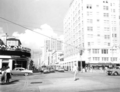 View westward of the intersection of Flagler Street and Biscayne Boulevard, 1958
 -
 La Época Department Store, a local Miami department store in the historic 1930s Walgreens Building at 200 E Flagler Street
 -
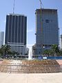 The eastern terminus of Flagler Street at Biscayne Boulevard with Bayfront Park in the foreground
 -
 101 East Flagler Street


25°46′27″N 80°11′37″W / 25.774107°N 80.193608°W
