
Huntington Avenue
This article needs additional citations for verification. (March 2011) |

Huntington Avenue is a secondary thoroughfare in the city of Boston, Massachusetts, beginning at Copley Square, and continuing west through the Back Bay, Fenway, Longwood, and Mission Hill neighborhoods. Huntington Avenue is signed as Route 9.[1]
Description
In the Back Bay neighborhood the avenue is primarily dominated by the Mother Church and headquarters of the Church of Christ, Scientist and the buildings of the Prudential Center shopping and office complex.
Also known as the Avenue of the Arts, the middle portion of Huntington Avenue is lined by many significant artistic venues and educational institutions in Boston, including Symphony Hall, Horticultural Hall, the New England Conservatory, Northeastern University, the Boston University Theatre (Huntington Theatre Company's mainstage), the Museum of Fine Arts, Wentworth Institute of Technology and the Massachusetts College of Art. The Isabella Stewart Gardner Museum is also only about a block from Huntington Avenue.
Near the Longwood Medical Area the street touches upon a number of medical research institutions and hospital complexes, including the Harvard Medical School.
At the point at which the street reaches the overpass of the Jamaicaway and the border of the town of Brookline, South Huntington Avenue runs towards Jamaica Plain Center and Route 9 continues west into Brookline as Boylston Street.
Public transportation
The "E" Branch of the MBTA Green Line roughly follows Huntington Avenue underground from Copley Square until it rises above ground at the Northeastern Portal. It then operates in a dedicated median of Huntington Avenue between Northeastern University and the Brigham Circle stop, where trains begin operating on the street mixed with traffic.
History
This section needs expansion. You can help by adding to it. (June 2008) |
Huntington Avenue began in Art Square (now Copley Square) and wended its way toward Brookline. It was originally called Western Avenue. By 1883 the square that had been named for the adjacent (and later relocated) Museum of Fine Arts was renamed Copley Square. The avenue originally began at the intersection of Claredon and Boylston Street and ran diagonally across the square past Trinity Church. In the 1960s this stretch was eliminated as part of a redesign of the square and now the avenue originates from the intersection of Dartmouth Street and St. James Avenue.
The street was named for Ralph Huntington (1784–1866). Huntington was one of the men who moved to have the Back Bay filled in. He donated money to many of the institutions in the Back Bay and later the Fenway.
Huntington Avenue, near Northeastern University, was the site of the old Boston Red Sox stadium and site of the first World Series game in 1903. A statue of Cy Young stands on the current day Northeastern campus to commemorate the location of the pitcher's mound of the Huntington Avenue Grounds ballpark.
Gallery
-
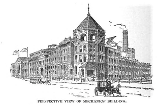 Mechanics' Hall, 1881
 -
 Huntington Ave. (at left), at Copley Square, 1889
 -
 Huntington Ave., 1920
 -
 Horticultural Hall, at corner of Huntington and Massachusetts Ave., 1920
 -
 Overview of Huntington Ave., 20th century, in the vicinity of the Museum of Fine Arts, Boston
 -

-
 Raised crosswalk across Huntington Ave in front of the New England Conservatory of Music, 2008


See also
- Boston Young Men's Christian Association
- Copley Square
- First Church of Christ, Scientist
- Horticultural Hall, Boston, Massachusetts
- Huntington Theatre Company
- Jordan Hall
- Longwood Medical and Academic Area
- Massachusetts College of Art and Design
- Museum of Fine Arts, Boston
- New England Conservatory
- Northeastern University
- Wentworth Institute of Technology
Demolished buildings
References
- ^ "Street Book - City of Boston". Cityofboston.gov. Retrieved 2011-08-17.
External links
- City of Boston Archives. Electric street lights on Huntington Avenue, c. 1910
