
Gachancipá: Difference between revisions
re-categorisation per CFD, Replaced: Category:Municipalities of Cundinamarca → Category:Municipalities of Cundinamarca [[Category:Cities, tow using AWB |
Marcocapelle (talk | contribs) →References: Removed Category:Muisca Confederation, unclear whether it already existed during the Muisca Confederation Tags: Mobile edit Mobile web edit Advanced mobile edit |
||
| (44 intermediate revisions by 25 users not shown) | |||
| Line 1: | Line 1: | ||
{{Infobox settlement |
|||
[[Image:MunsCundinamarca Gachancipa.png|thumb|right|250px|Location of the town and municipality of '''Gachancipá''' in [[Cundinamarca Department]].]] |
|||
|name = Gachancipá |
|||
|native_name = |
|||
|nickname = |
|||
|motto = |
|||
|settlement_type = [[Municipalities of Colombia|Municipality]] and town |
|||
|image_skyline = Parque principal Gachancipá.jpg |
|||
|imagesize = |
|||
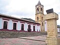
|image_caption = Central square |
|||
|image_flag = Flag of Gachancipá.svg |
|||
|image_seal = Escudo de Gachancipá.svg |
|||
|image_map = Colombia - Cundinamarca - Gachancipá.svg |
|||
|mapsize = 250px |
|||
|map_caption = Location of the municipality and town inside Cundinamarca department of Colombia |
|||
|pushpin_map = Colombia |
|||
|pushpin_mapsize = 250 |
|||
|pushpin_map_caption = Location in Colombia |
|||
|subdivision_type = Country |
|||
|subdivision_name = {{flag|Colombia}} |
|||
|subdivision_type1 = [[departments of Colombia|Department]] |
|||
|subdivision_name1 = {{flagicon image|Flag of Cundinamarca.svg}} [[Cundinamarca Department|Cundinamarca]] |
|||
|subdivision_type2 = Province |
|||
|subdivision_name2 = [[Central Savanna Province]] |
|||
|leader_title = Mayor |
|||
|leader_name = José Joaquín Cubides Ariza<br><small>(2016-2019)</small> |
|||
|established_title = Founded |
|||
|established_date = 1 January 1612 |
|||
|area_magnitude = |
|||
|area_total_km2 = 43.06 |
|||
|area_total_sq_mi = |
|||
|area_land_km2 = |
|||
|area_land_sq_mi = |
|||
|area_water_km2 = |
|||
|area_water_sq_mi = |
|||
|area_water_percent = |
|||
|area_urban_km2 = 1.03 |
|||
|area_urban_sq_mi = |
|||
|area_metro_km2 = |
|||
|area_metro_sq_mi = |
|||
|population_as_of = 2018 census |
|||
|population_footnotes = <ref>[http://www.citypopulation.de/en/colombia/cundinamarca/25295/ Citypopulation.de]</ref> |
|||
|population_total = 17026 |
|||
|population_density_km2 = auto |
|||
|population_density_sq_mi = |
|||
|population_metro = |
|||
|population_density_metro_km2 = |
|||
|population_density_metro_sq_mi = |
|||
|population_urban = 11252 |
|||
|population_density_urban_km2 = auto |
|||
|coordinates = {{coord|4|59|27|N|73|52|23|W|display=inline,title}} |
|||
|timezone = Colombia Standard Time |
|||
|utc_offset = -5 |
|||
|timezone_DST = |
|||
|utc_offset_DST = |
|||
|elevation_m = 2568 |
|||
|elevation_ft = |
|||
|website = [http://www.gachancipa-cundinamarca.gov.co/ Official website] |
|||
|footnotes = |
|||
}} |
|||
'''Gachancipá''' is a municipality and town of [[Colombia]] in the [[Central Savanna Province]], part of the [[Departments of Colombia|department]] of [[Cundinamarca Department|Cundinamarca]]. The urban centre is located on the [[Altiplano Cundiboyacense]] at {{convert|42|km|mi}} from the capital [[Bogotá]]. The municipality borders [[Guatavita]] and [[Tocancipá]] in the south, [[Sesquilé]] and [[Guatavita]] in the east, [[Nemocón]] in the west and [[Suesca]] in the north.<ref name="websiteGachancipá">{{in lang|es}} [http://www.gachancipa-cundinamarca.gov.co/informacion_general.shtml Official website Gachancipá] {{Webarchive|url=https://archive.today/20140310084830/http://www.gachancipa-cundinamarca.gov.co/informacion_general.shtml |date=2014-03-10 }}</ref> |
|||
== Etymology == |
|||
'''Gachancipá''' is a municipality and town of [[Colombia]] in the [[Departments of Colombia|department]] of [[Cundinamarca]]. |
|||
The name Gachancipá comes from [[Chibcha language|Chibcha]] and means "Pottery of the ''zipa''".<ref name="websiteGachancipá"/> |
|||
== History == |
|||
| ⚫ | |||
The area of Gachancipá before the [[Spanish conquest of the Muisca|Spanish conquest]] was inhabited by the [[Muisca people|Muisca]], organised in their loose [[Muisca Confederation]]. Gachancipá, as the name suggests, was ruled by the ''[[zipa]]'' based in [[Bogotá|Bacatá]]. |
|||
Modern Gachancipá was founded on January 1, 1612 but the founders are unknown.<ref name="websiteGachancipá"/> |
|||
{{coord|5|00|N|73|53|W|display=title|region:CO_type:city_source:GNS-enwiki}} |
|||
In the late 18th century [[List of Muisca scholars|Muisca scholar]] [[José Domingo Duquesne]] was based in Gachancipá. A school in the town is named after him.<ref>{{in lang|es}} [http://www.gachancipa-cundinamarca.gov.co/Proyectos_Registrados.shtml?apc=gixxEducaci%F3n1-&x=1997265 School named after Duquesne in Gachancipá]</ref> |
|||
| ⚫ | |||
[[Category:Cities, towns and villages in the Cundinamarca Department]] |
|||
[[Category:Cities, towns and villages in Colombia]] |
|||
== Economy == |
|||
{{Colombia-geo-stub}} |
|||
The economy of Gachancipá traditionally was centered around [[agriculture]] and [[livestock]] farming. In recent years flowers are cultivated in the municipality.<ref name="websiteGachancipá"/> |
|||
== Gallery == |
|||
<gallery> |
|||
File:Iglesia San Bartoleme Apostol.jpg|Church of Gachancipá |
|||
File:IglesiadeGanchancipá.jpg|Church |
|||
File:La Gacha.JPG|Monument to the indigenous people |
|||
</gallery> |
|||
== References == |
|||
{{reflist}} |
|||
{{commons category|Gachancipá}} |
|||
| ⚫ | |||
{{DEFAULTSORT:Gachancipa}} |
|||
[[es:Gachancipá]] |
|||
| ⚫ | |||
[[Category:Populated places established in 1612]] |
|||
[[Category:1612 establishments in the Spanish Empire]] |
|||
Latest revision as of 11:28, 7 April 2023
Gachancipá | |
|---|---|
Municipality and town | |
 Central square | |
 Flag  Seal | |
 Location of the municipality and town inside Cundinamarca department of Colombia | |
 Gachancipá Location in Colombia | |
| Coordinates: 4°59′27″N 73°52′23″W / 4.99083°N 73.87306°W | |
| Country | |
| Department | |
| Province | Central Savanna Province |
| Founded | 1 January 1612 |
| Government | |
| • Mayor | José Joaquín Cubides Ariza (2016-2019) |
| Area | |
| • Municipality and town | 43.06 km2 (16.63 sq mi) |
| • Urban | 1.03 km2 (0.40 sq mi) |
| Elevation | 2,568 m (8,425 ft) |
| Population (2018 census)[1] | |
| • Municipality and town | 17,026 |
| • Density | 400/km2 (1,000/sq mi) |
| • Urban | 11,252 |
| • Urban density | 11,000/km2 (28,000/sq mi) |
| Time zone | UTC-5 (Colombia Standard Time) |
| Website | Official website |
Gachancipá is a municipality and town of Colombia in the Central Savanna Province, part of the department of Cundinamarca. The urban centre is located on the Altiplano Cundiboyacense at 42 kilometres (26 mi) from the capital Bogotá. The municipality borders Guatavita and Tocancipá in the south, Sesquilé and Guatavita in the east, Nemocón in the west and Suesca in the north.[2]
Etymology[edit]
The name Gachancipá comes from Chibcha and means "Pottery of the zipa".[2]
History[edit]
The area of Gachancipá before the Spanish conquest was inhabited by the Muisca, organised in their loose Muisca Confederation. Gachancipá, as the name suggests, was ruled by the zipa based in Bacatá.
Modern Gachancipá was founded on January 1, 1612 but the founders are unknown.[2]
In the late 18th century Muisca scholar José Domingo Duquesne was based in Gachancipá. A school in the town is named after him.[3]
Economy[edit]
The economy of Gachancipá traditionally was centered around agriculture and livestock farming. In recent years flowers are cultivated in the municipality.[2]
Gallery[edit]
-
 Church of Gachancipá
 -
 Church
 -
 Monument to the indigenous people


References[edit]
- ^ Citypopulation.de
- ^ a b c d (in Spanish) Official website Gachancipá Archived 2014-03-10 at archive.today
- ^ (in Spanish) School named after Duquesne in Gachancipá