
Çanlı Kilise
Coordinates: 38 ° 17 ′ 54.6 ″ N , 34 ° 8 ′ 7 ″ E


The Çanlı Kilise ( Turkish for bell church ) is a Byzantine church in southern Cappadocia . It is surrounded by a settlement with apartments, farm buildings and other churches dug into the rock . Since the earlier name of the place is not known, the settlement is also referred to as Çanlı Kilise in the specialist literature. The settlement and church were probably built in the 10th and 11th centuries.
location
The church is located on the southern slope of a table mountain between the places Akhisar in the west and Çeltek in the northeast, in the central district of the Turkish province of Aksaray . The settlement stretches from west to east in a semicircle about one kilometer in the south around Table Mountain. The mountain is about three kilometers away from the two places, the distance to Aksaray is about ten kilometers. The site can be reached from Akhisar as well as from Çeltek via a gravel road.
Research history
The first photos of the church were taken in 1895 by the Russian art historian Jakow Iwanowitsch Smirnow (1869–1918), to which the Austrian art historian Josef Strzygowski referred in his description of the building in 1903 . In 1906, the German historian Hans Rott visited the church on a trip to Asia Minor, followed by the British explorer Gertrude Bell together with the archaeologist William Mitchell Ramsay in 1907. Further publications were made by Marcell Restle in 1979 and the same with Friedrich Hild in 1981. The wall paintings were published in 1980 SY Ötüken. In June 1994, the art historian Robert Ousterhout began a thorough survey of the church and the surrounding settlement with students from the University of Illinois , the University of Newcastle upon Tyne and Hacettepe University .
church

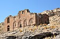
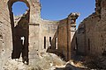
The north-east facing Çanlı Kilise is a three-aisled basilica with a cross -domed vault . The central nave was covered by a barrel vault in the southwest-northeast direction , the transept in the northwest-southeast direction. The corner parts of the narrow aisles corresponded to the central nave in the direction of the vaults. In the apses , the barrels each ended in a semi-dome. The central field was crowned by a dome that rested on a twelve-sided drum . The roof structure was supported by four pillars with simple combatant capitals . When Rott and Bell visited, two of them were still standing, around 1954 the roof collapsed completely. A single-nave side chapel (parekklesion) is built on the north-west side of the church. It is the same length as the main church and was covered by a barrel vault resting on two belt arches , with a semi-domed apse to the northeast. Both churches have a common narthex in front of them in the south-west, possibly later added . Its northern part was barrel-vaulted and had a door in the west, the southern part was two-story with three cross vaults on the lower floor and a barrel on the upper floor. Entrances were in the south and west, on the upper floor there were three passages to the gallery above the naos . The main and side churches were richly decorated with frescoes , of which only very sparse remains have survived. A number of formerly seven saints in the bishop's robe in the main apse can still be seen in parts. The interior was illuminated by four slot-shaped windows in the side walls, three in the middle apse and one in each of the side apses. There were also further windows on the upper floor and four in the drum. The outer walls are decorated by horseshoe-shaped niches around the windows, which are bricked, while the load-bearing masonry consists of stone blocks. The apses are clad polygonally on the outside, the middle pentagonal, the sides triangular. Due to the architectural style and the frescoes, the church is dated around the 11th century.
Shortly after the end of the first season of Ousterhout's investigations, predatory graves found two mummies in the northern narthex that they were trying to sell. They were arrested and the mummies were taken to the Aksaray Museum by police . Thereupon the archaeologist Demet Kara started rescue excavations in cooperation with the director of the Museum Mühsin Endoğru. In the process, 16 graves were uncovered in the northern narthex, which were carved into the rock below. All but two of them had been looted, but it could be proven that they had been documented several times until post-Byzantine times in the 16th century. In the rubble above, in addition to small finds such as coins, jewelry, clothing and fragments of manuscripts, other mummies and mummy fragments of children and adults were found. The mummification is due to storage in the dry, volcanic soil. They are on display at the Aksaray Museum today.
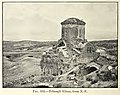
Çanlı Kilise 1907, photograph by Gertrude Bell
View from the east
Apses

Remains of holy images in the main apse

Remnants of frescoes in the passage from the central to the north apse
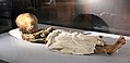
Children's mummy in the Aksaray Museum


settlement

The Table Mountain, on whose southern slope the Çanlı Kilise stands, is horseshoe-shaped there. Along its edge, an extensive cave settlement stretches from the church about 200 meters to the east and almost a kilometer to the northwest. According to Ousterhout's research, it consists of about 25 larger and a dozen smaller residential units dug into the rock. They consist of living rooms, utility rooms and one or more churches or chapels. Since the sacred buildings - with one exception - are not assigned a central position, but rather belong to the living spaces, Ousterhout sees in the units, in contrast to earlier researchers, no monasteries, but residential complexes (courtyard residences) . They are usually grouped in a semicircle around a courtyard. Countless small fans that served as dovecotes can now be seen on the central front. Since there was often a portico in front of the cave structures , they were hidden behind it. They were accessible from the interior through windows so that the pigeon dung could be harvested. In the region, which has little fertile soil, it was of great importance as a fertilizer for agriculture. The structured main room behind the facade was partly rectangular, partly also cross-shaped, and there were additional rooms such as warehouses, stables, cisterns with inflow from above and kitchens with conical vaults and smoke exhaust. When the settlement lost its importance, the residential complexes were divided up for use by several families, later abandoned or only used for agriculture.
Ousterhout counted about thirty rock churches and chapels on the site, most of which were on the side of the courtyard. Some of them included burial places in the narthex or a side chamber accessible from there. The predominant building type is the cross-domed church with a central dome supported by finely crafted columns, corresponding to the Çanlı Kilise, but barrel vaults and cross-shaped interiors are also represented. The frequently occurring ribbed vaults are remarkable . A choir screen ( templon ) is rarely available, in most churches the choir is only separated from the naos by one or two low steps. In many of the churches remains of frescoes can be seen, but only a few details can be seen. One church at the northwest end of the settlement shows a Deësis in the apse, in another, in the center of the village, the legend of the Three Hebrews is depicted in a fiery furnace . In addition to the churches dug into the rock, foundations of a number of brick churches have also been found. Due to the frescoes and other architectural details, the churches and the settlement could be dated to the 10th and 11th centuries.
Above the residential complexes there are also some “underground cities” carved into the rock, which, however, are more likely to be described as underground villages due to their small size compared to the corresponding cave complexes in Cappadocia. The entrance tunnels are closed with the usual rolling stones, the inner architecture, however, differs from other Cappadocian underground cities. In addition to architectural elements made of stone, such as cornices and vaults, there are also stone walls. Ousterhout suspects that at least some are formerly open courtyard complexes that were buried by landslides.
In the course of the investigations in the 1990s, three further settlement complexes were discovered. One is about a kilometer to the north, and mosaic remains have been found in the church. The settlement can be dated to the early Christian period in the 6th century. Another complex is one kilometer to the east. Presumably it was a monastery, the remains of which have been heavily buried. The third settlement is about three kilometers northeast in the direction of Çeltek and included three rock-hewn churches. All three locations have not yet been thoroughly explored.

Facade with dovecotes

Residential complex

Interior of a church

Interior of a church


literature
- Hans Rott: Asia Minor Monuments , Leipzig 1908, pp. 257–262 ( full text )
- WM Ramsay, Gertrude L. Bell: The Thousand and One Churches , Hodder and Stoughton, London 1909 pp. 404-418.
- Robert Ousterhout: The 1994 Survey at Akhisar - Çanlı Kilise In: XII. Araştırma Sonuçları Toplantısı II. Cilt . Ankara 1996 ISBN 975-17-1629-2 , pp. 165-180.
- Robert Ousterhout: Survey of the Byzantine Settlement at Çanlı Kilise in Cappadocia: Results of the 1995 and 1996 Seasons In: Dumbarton Oaks Papers 51 (1997) pp. 301-306.
- Robert Ousterhout: A Byzantine Settlement in Cappadocia . Dumbarton Oaks, 2005 ISBN 9780884023104
Web links
Individual evidence
- ^ Josef Strzygowski: Asia Minor. New territory in art history. Leipzig 1903 pp. 156–157
- ^ Marcell Restle: Studies on the early Byzantine architecture of Cappadocia . Publishing house of the Austrian Academy of Sciences, 1979, ISBN 3700102933 , pp. 133–135
- ^ Marcell Restle, Friedrich Hild: Cappadocia. Kappadokia, Charsianon, Sebasteia and Lykandos , Verlag der Österreichischen Akademie der Wissenschaften, Vienna 1981, ISBN 3-7001-0401-4 (= Tabula Imperii Byzantini , Volume 2) pp. 277-278
- ↑ SY Ötüken: Akhisar Canli Kilise Frescoları In: Bedrettin Cömert'e Armağan . Ankara 1980 pp. 303-320