Acevedo (Colombia)
| Acevedo | ||
|---|---|---|
|
Coordinates: 1 ° 48 ′ N , 75 ° 53 ′ W Acevedo on the map of Colombia
|
||
|
Location of the municipality of Acevedo on the map of Huila
|
||
| Basic data | ||
| Country | Colombia | |
| Department | Huila | |
| City foundation | 1756 | |
| Residents | 35,877 (2019) | |
| City insignia | ||
| Detailed data | ||
| surface | 612 km 2 | |
| Population density | 59 people / km 2 | |
| height | 1348 m | |
| Time zone | UTC -5 | |
| City Presidency | Luzdey Artunduaga Castro (2016-2019) | |
| Website | ||
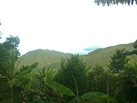
| Landscape in Acevedo | ||
Acevedo is a municipality ( municipio ) in the department of Huila in Colombia .
geography
Acevedo is located in the south of Huila , in the Subsur sub- region , 182 km from Neiva at an altitude of 1348 m above sea level. NN and has an average temperature of 22 ° C. The area of the municipality is characterized by the Serranía de la Ceja , which belongs to the eastern cordillera of the Colombian Andes . The municipality borders in the north on Suaza , in the south on San José del Fragua in the Departamento del Caquetá and on Piamonte in the Departamento del Cauca , in the east on Belén de los Andaquíes in Caquetá and in the west on Palestina , Pitalito and Timaná .
population
The municipality of Acevedo has 35,877 inhabitants, of which 7044 live in the urban part (cabecera municipal) of the municipality (as of 2019).
history
The Acevedo area has been inhabited by the Andaquí indigenous people since around the year 700 . During the colonial period, the Spanish founded various places in the region in order to better control the indigenous people. Today's Acevedo has been in its current location since 1756, initially under the name San Francisco Javier de la Ceja . In the 19th century the community was temporarily given the status of a community (under the name Cea ), but was then reassigned to Suaza . Since 1898 the place has finally had the status of a municipality , initially as La Concepción . Acevedo was given its current name in 1935 in honor of José Acevedo y Gómez .
economy
The main industry of Acevedo is agriculture . Coffee in particular is grown, but other agricultural products also play a role. There is also cattle , milk and poultry production .
tourism
In the territory of the municipality of Acevedo there is part of the Cueva de los Guácharos Natural Park , in which especially birds can be observed. The municipality also has its own La Correntosa Natural Park .
Web links
- Alcaldía de Acevedo - Huila. Alcaldía de Acevedo - Huila, accessed on March 26, 2019 (Spanish, website of the municipality).
Individual evidence
- ^ Información del municipio. Alcaldía de Acevedo - Huila, accessed March 26, 2019 (Spanish, information on the geography of the municipality).
- ↑ ESTIMACIONES DE POBLACIÓN 1985 - 2005 Y PROYECCIONES DE POBLACIÓN 2005 - 2020 TOTAL DEPARTAMENTAL POR ÁREA. (Excel; 1.72 MB) DANE, May 11, 2011, accessed on March 26, 2019 (Spanish, extrapolation of the population of Colombia).
- ↑ Pasado, presente y futuro. Alcaldía de Acevedo - Huila, accessed March 26, 2019 (Spanish, information on the history of the municipality).
- ↑ Economía. Alcaldía de Acevedo - Huila, accessed March 26, 2019 (Spanish, information on the municipality's economy).
- ↑ Sitios de interés. Alcaldía de Acevedo - Huila, accessed on March 26, 2019 (Spanish, information on sights in the municipality).


