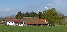
Aglasterhof
|
Aglasterhof
Lauterhofen market
Coordinates: 49 ° 24 ′ 48 ″ N , 11 ° 29 ′ 33 ″ E
|
|
|---|---|
| Height : | 565 m above sea level NHN |
| Residents : | 2 (1987) |
| Incorporation : | May 1, 1978 |
| Postal code : | 92283 |
| Area code : | 09189 |
|
The wasteland of Aglasterhof, part of the market town of Lauterhofen
|
|
The Einöde Aglasterhof is a district of the Lauterhofen market in the Upper Palatinate district of Neumarkt in the Upper Palatinate . The name is derived from the ahd. Aglastra = Elster and means Elsternhof.
geography
Aglasterhof is located about ten kilometers north-northwest of Lauterhofen and is at an altitude of 565 m above sea level. NHN .
history
The rulership relationships between the imperial city of Nuremberg and the Pfaffenhofen office around the Aglasterhof were not finally settled until 1714, when the Palatinate was granted high authority , while the lower jurisdiction remained with the imperial city.
Due to the administrative reforms carried out in the Kingdom of Bavaria at the beginning of the 19th century , the place became part of the independent rural community of Traunfeld , which also included the village of Dippersricht and the two wastelands of Eratsmühle and Frankenhof . However, the Frankenhof south of Traunfeld no longer exists today. In the course of the communal territorial reform carried out in Bavaria in the 1970s , the Aglasterhof was incorporated into the Lauterhofen community together with the entire Traunfeld community in 1978. In 1987 the Aglasterhof had two residents.
traffic
The connection to the public road network is established by a municipal road that leads to the NM 9 county road, which passes about half a kilometer west of the town .
Attractions
Web links
- Aglasterhof in the BayernAtlas (accessed on May 7, 2017)
- Aglasterhof on a historical map (BayernAtlas Klassik) (accessed May 7, 2017)
Individual evidence
- ↑ Population of Aglasterhof
- ↑ Aglasterhof in the local database of the Bavarian State Library Online
- ↑ M. Lassleben: Die Oberpfalz, Volume 42 1954, p. 47
- ^ Commission for Bavarian State History: Historical Atlas of Bavaria: Part Altbayern, issues 16-17 1967, p. 240
- ^ Composition of the community of Traunfeld, which existed until 1978
- ↑ Former location of the Frankenhof
- ↑ Historical municipality register for the Federal Republic of Germany (1970–1982), page 650

