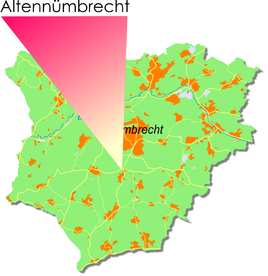
Altennümbrecht
|
Altennümbrecht
municipality Nümbrecht
Coordinates: 50 ° 53 ′ 13 ″ N , 7 ° 32 ′ 8 ″ E
|
|
|---|---|
| Height : | 269 m |
| Residents : | 141 (December 31, 2006) |
| Postal code : | 51588 |
| Area code : | 02293 |
|
Location of Altennümbrecht in Nümbrecht
|
|
Altennümbrecht is a district of Nümbrecht in the Oberbergischer Kreis in southern North Rhine-Westphalia within the administrative district of Cologne .
Location and description
The place is located between the main town Nümbrecht in the north and Harscheid in the south, on Landstrasse 320. The town is about 1.6 km south of the center of Nümbrecht as the crow flies.
history
First mention
The place was mentioned for the first time in 1316, namely "Division of the people of Nümbrecht by Engelbert von Sayn". Spelling of the first mention : Aldin Nunbrecht .
Bus and train connections
Citizen bus
The bus stop for the community of Nümbrecht.
Route: Geringhauser Mühle
- Harscheid-Langenbach-Geringhauser Mill-Buch-Haan-Hömel
- Wirtenbach-Geringhausen-Nippes-Nümbrecht / bus station.
Public bus
Stop: Altennümbrecht
- 346 Nümbrecht bus station, school center ( OVAG , weekday traffic)
swell
- ^ Klaus Pampus: First documentary naming of Oberbergischer places (= contributions to Oberbergischen history. Sonderbd. 1). Oberbergische Department 1924 eV of the Bergisches Geschichtsverein, Gummersbach 1998, ISBN 3-88265-206-3 .

