
Break (Nümbrecht)
|
fracture
municipality Nümbrecht
Coordinates: 50 ° 54 ′ 29 " N , 7 ° 35 ′ 12" E
|
|
|---|---|
| Height : | 240 m above sea level NN |
| Residents : | 204 (December 31, 2006) |
| Postal code : | 51588 |
| Area code : | 02293 |
 Location of Bruch in Nümbrecht
|
|
Bruch is a district of Nümbrecht in the Oberbergischer Kreis in southern North Rhine-Westphalia within the administrative district of Cologne .
geography
The place is located around three kilometers east of the center of Nümbrecht as the crow flies at an altitude of around 240 m (old district), which rises to around 270 m in the new development area Finkenhähnchen (from the 1970s). Bruch lies on a flat valley slope of the Homburger Bröl , which is formed from the Central Devonian Grauwacken ( Eifelium ), which are covered by a layer of clay from the periglacial solifluction . You can find this Grauwacken openly in two smaller (today no longer used and almost completely overgrown) quarries located in the area south of Walter-Peitgen-Straße in the direction of Distelkamp . The Eisenstrasse, on which the iron ore was transported from Distelkamp to the hammer mill near Grötzenberg, indicates the mining of Devonian iron ores in the immediate vicinity (from around the end of the 16th century) in Distelkamp .
Two smaller streams used to drain visibly (today largely piped) in the old town center of Bruch zur Homburger Bröl. The one, the source of which can still be found today in the Brucher Forest, flowed in the area of the “In der Schlade” road to Brölbach. From 1907, its water was collected in an elevated tank below the source area and supplied the Brucher houses centrally with water, which until then had been pumped from wells. The name Schlade is derived from the Low German term “Slôt” and the Frisian “slûût”, which denote a ditch. The other stream flowed through the so-called Langensiefen (area of today's Walter-Peitgen-Straße). The term “Siefen” (also “ Siepen ”) is derived from the Bergisch dialect and indicates damp and wet areas. The sieves, which can often be found in Oberbergisches Land, represent a special form of notch valleys, as they do not have a perennial stream and are to be regarded as the beginnings of the valley, the basins of which are often referred to as Schladen. This notched valley character of the Langensiefenbach was very easy to recognize until the 1970s. The stream was then piped and the Kerbtal was largely filled in. Bruch belongs to the natural spatial main unit "Bergland der upper Agger and Wiehl" or to the natural spatial sub-unit "Unterwiehl Bergland" (after H. Müller-Miny - see also " Natural spatial main units of Germany "). Climatic classification: The annual precipitation is in the range of 1150 mm, the mean January temperature is around 0.5 ° C and the mean July temperature around 16 ° C (1891–1930).

Profile through the Bröltal at the level of Bruch
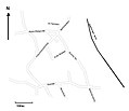
Bruch's road network

Detail from the Mercator map of 1575


history
In 1575 the place was mentioned for the first time as a place in the map of the Bergisches Amt Windeck and the rule of Homburg by A. Mercator .
The first settlement areas in Oberbergischen in the early Middle Ages were not in the wet valley meadows (which, incidentally, were not settled until the 19th century), but on the drier ridges (e.g. Nümbrecht , Marienberghausen, etc.). After the high places were settled and new settlement and agricultural land had to be developed due to the population growth, the spring troughs (Schladen, Siefen) that appeared near the plateaus met the settlers in a special way. B. vital to have water in the immediate vicinity. Place names in these more recent cleared areas (850 - 1300) usually end with -bruch, rod / roth, -siepen / siefen ...
Nicke (1995) therefore refers to settlements such as Bruch as Siefenorte.
The spelling of the first mention was Tzum Broich . In the “Chronicle of the communities of Nümbrecht and Marienberghausen” you can find the following information about the place name: 1. Dialect form: Om Brooch; 2. Documented form with year: 1575 Broich; 3. Interpretation of the place name: frequent field name for swamp moorland, swamp in a meadow; 4. Founding period: 1300–1600; 5. Number of farm owners / families: 2 families in 1579 based on the Fuder-Haber slip of the parish of Nümbrecht.
Before the Siegburg settlement in 1604, Bruch belonged to the Hundschaft ( Honnschaft ) of the parish Bröl (together with Ober- and Niederrbröl, Grötzenberg, Winterborn, Oberbreidenbach, Drinhausen, Birkenbach, Bieberstein and Scheidt).
In almost every village of Homburger little country in the 16th century lived own people the rulers, which was prescribed exactly what they had to do it and leave it as a Weistum of the 16th century. proves: It is about compulsory labor that the subjects of the two gentlemen of Homburg , Count Ludwig the Elder of Wittgenstein (1532-1605) and Count Heinrich zu Sayn (1539-1606), perform annually "on the Homburg House" were guilty. In this wisdom it says u. a .: The Hundschaft B r ö l mowed the long meadow under the grove - today BURGWIESE (Homburg Castle!) - made the hay and had to bring it in. So from Bruch the people had to move to the foot of the Schlossberg to make hay! The self- men were not allowed to marry a servant of another sovereign without the permission of their master . The neighboring countries were then simply considered "foreign countries". B. the rule Gimborn, Neustadt north of the Agger, the Duchy of Berg in the west and after 1604 also the parish of Waldbröl belonging to Berg.
According to the Homburg school regulations of Count Karl Friedrich zu Sayn and Wittgenstein from 1698 , the Bruch children had to attend school in Drinsahl ("Drülshöhler School"). In these school regulations it says to justify compulsory schooling and a .: "... and if the people are poorly kept their children to school, this is decreed once for all, as is customary in other reformed places, so that the wealthy, out of sluggishness or other earthly uses, give their children away from the Keeping school, they too, as if they really sent the same to pay the school fees to those praeceptoriby (teachers); But whoever finds himself in poverty, should nevertheless send his children there, and, as is customary, the schoolmaster should be paid from the almonds ... "
In 1915, the Bielstein – Waldbröl small railway was opened on the eastern outskirts of Bruch : with a stop "Bruch-Grötzenberg" (cf. the course book from 1944, p. 63 bottom right:) above the former Protestant elementary school in Grötzenberg (the tracks and the embankment , which was removed in the 1980s, can still be seen on the picture "View of Grötzenberg" and on a picture with a railcar that was taken from Bruch in the mid-1950s).
The number of inhabitants developed in Bruch as follows: 1817: 42; 1830: 47; 1843: 35 (in 7 buildings); 1851: 47; 1961: 124; 1974: 143 and 2004 176 inhabitants.
The majority Protestant residents belong to the Winterborn district of the Protestant parish of Nümbrecht. "The Winterborn district, in the northern part of our parish, came into being after the Second World War. With the establishment of the third parish in Winterborn in 1951, Winterborn became the third parish (the so-called" upper district ").
Attractions
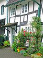
In the village of Bruch there are well-preserved half-timbered houses , most of which date from the 19th century and are built in the Franconian tradition (courtyard forms with separate buildings for the individual functions and uses (dwelling house, stable building, store, barn)). In Oberbergischen (also in Bruch), the so-called "living-stable-house" occurs due to the often tight space conditions, in which the residential house and stable are under one roof and the barn is apart. In addition, the Franconian courtyards are eaves (i.e. they stand with the long side facing the street) (H. Nicke, 1995, p. 43 f.). Some of them were built on the foundations of the previous houses.
photos

Half-timbered houses
Oldest house (1728)

Winter 1976

Break (2004)

View of Grötzenberg - in the foreground the tracks of the former Bielstein – Waldbröl small railway (closed in 1966) (Easter 1955)

View towards Winterborn (background on the right: the old transformer house of the Malzhagen electricity cooperative and behind it the chimney of the former paper mill in Winterborn), 1955

Haymaking in Bruch with a view of Grötzenberg around 1940


Personalities
- Walter Peitgen , former mayor
- Prof. Dr. Heinz-Otto Peitgen , German mathematician
- Dr. Gerhard Sohn, born and raised in Bruch, after studying economics, initially worked as a ministerial official in the State Chancellery under Johannes Rau and then as ministerial director of the Energy, Coal and Mining Department in the North Rhine-Westphalian Ministry of Economics and Medium-Sized Enterprises, Technology and Transport ; since 1999 executive board member of the General Association of the German Hard Coal Mining . He died on December 9, 2006 at the age of 65.
Bike paths
The following bike tours cross Bruch:
- Half-timbered route : There are numerous renovated half-timbered houses along the route. There are 8 height differences to be mastered.
- Family route : A small circular route of 13 km with only a small difference in altitude to be overcome.
Starting point Nümbrecht
| Route name | Waymarks | Driving distance | Path length |
| Half-timbered route | Nümbrecht - Marienberghausen - Lindscheid - Benroth - Langenbach - Berkenroth - Gut Rottland - direction Wirtenbach - Bruch | 40 km | |
| Family route | Nümbrecht - Kurpark Nümbrecht - duck pond - lookout tower - Bruch - Grötzenberg - Wirtenbach - Ahlbusch - Ödinghausen - past the sports park and golf course Nümbrecht - Nümbrecht Kurpark | 13 km |
Citizen bus
The bus stop for the community of Nümbrecht.
Route: Oberbernbach
- Distelkamp-Ödinghausen-Nümbrecht / bus station
Web links
- Bläck Fööss : Buuredanz on YouTube , accessed on January 2, 2019 (music video from 1977, shot in Bruch).
literature
- Brinkmann and Müller-Miny: The Oberbergische Kreis , Bonn 1965.
swell
- ^ Karl Schmitz, Erdgeschichte des Oberbergischen, Gummersbach 1974, Fig. 6
- ^ Nümbrechts Hefte: Bruch - A historical village. Kirsch-Verlag, Nümbrecht 1977
- ↑ Sturmfels / Bishop: Our place names. Ferd. Dümmler Verlag, Bonn 1961
- ^ Herbert Nicke : Relief genesis of the southern Bergisches Land between Wupper and Sieg. Geographical Institute of the University of Cologne, Cologne 1983
- ^ Klaus Pampus: First documentary mentions of Oberbergischer places . Ed .: Oberberberg Department of the Bergisches Historisches Verein. Gronenberg, Gummersbach 1997, ISBN 3-88265-206-3 .
- ^ Herbert Nicke : The Oberbergische Land - A landscape portrait, Wiehl 1995
- ↑ Dr. Heinrich Schild : Chronicle of the communities Nümbrecht and Marienberghausen. Gummersbach, 1977, page 21ff
- ↑ Unpublished manuscript by Dr. W. Schoppmann on the occasion of the 850th anniversary of Winterborn , August 1994.
- ^ Karl Heckmann : History of the former imperial rule Homburg an der Mark. Bonn 1939.
- ↑ http://pkjs.de/bahn/Kursbuch1944/Teil3/240k.jpg
- ↑ https://deacademic.com/pictures/dewiki/87/Winterborn-triebwagen-k.jpg
- ↑ [1] , History of the Protestant Parish Nümbrecht-Winterborn, viewed on November 29, 2018

On the hardt | Abbenroth | Ahebruch | Ahlbusch | Alsbach | Altennümbrecht | Bierenbachtal | Breunfeld | Benroth | Berkenroth | Birkenbach | Breitewiese | Brünglinghausen | Break | Büschhof | Book | Distelkamp | Drinsahl | Elsenroth | Erlinghausen | Friedenthal | Gaderoth | Gerhardsiefen | Geringhausen | Geringhauser Mill | Göpringhausen | Grötzenberg | Grünthal | Grunewald | Guxmühlen | Haan | Hammer mill | Hardt | Harscheid | Hasenberg | Heddinghausen | Heather | Heisterstock | Hillenbach | Elevated roads | Höferhof | Hömel | Homburg-Bröl | Homburg paper mill | Huppichteroth | Small height | Krahm | Kurtenbach | Langenbach | Linden tree | Lindscheid | Lindscheider mill | Hole | Löhe | Malzhagen | Marienberghausen | Mildsiefen | Mühlenthal | Nallingen | Neuenberg | Neuroth | Niederbröl | Niederbreidenbach | Lower Elbe | Niederstaffelbach | Ankle | Oberbech | Oberbernbach | Oberbreidenbach | Upper Elves | Oberstaffelbach | Ödinghausen | Prombach | Riechenbach | Rommelsdorf | Röttgen | Rose | Schönhausen | Schönthal | Spreitgen | Stockheim | Stranzenbach | Street | Überdorf | Under the hardt | Forewood | Windhausen | Winterborn | Wirtenbach | Wolf scribe