Amarasi (district)
| Kecamatan Amarasi Amarasi district
|
|
|---|---|
 |
|
| Basic data | |
| Country | Indonesia |
| province | East Nusa Tenggara |
| Administrative district | Kupang |
| Seat | Nonbes |
| surface | 155.1 km² |
| Residents | 16,918 (2017) |
| density | 109 inhabitants per km² |
| ISO 3166-2 | ID-NT |
Coordinates: 10 ° 12 ′ S , 123 ° 58 ′ E
Amarasi is an Indonesian district ( Kecamatan ) in the west of the island of Timor .
geography
| "Village" (Desa) | Administrative headquarters | surface | Residents | Population density |
|---|---|---|---|---|
| Oesana | Oesana | 11.91 km² | 1475 | 123.85 |
| Nonbes | Nonbes | 42.52 km² | 3504 | 82.41 |
| Ponain | Ponain | 19.14 km² | 2276 | 118.91 |
| Tesbatan | Tesbatan | 10.53 km² | 1453 | 137.99 |
| Kotabes | Kotabes | 12.66 km² | 2173 | 171.64 |
| Apren | Apren | 8.98 km² | 1923 | 214.14 |
| Oenoni | Oenoni | 27.18 km² | 1452 | 53.42 |
| Tesbatan II | Tesbatan II | 8.58 km² | 1322 | 154.08 |
| Oenoni II | Oenoni II | 13.59 km² | 1340 | 98.6 |
Location in East Nusa Tenggara Province
|
The district is located in the south of the government district of Kupang in the province of East Nusa Tenggara (Nusa Tenggara Timur) . To the north are the districts of Ostkupang (Kupang Timur) and Amabi Oefeto , to the east of Ostamarasi (Amarasi Timur) , to the south of Südamarasi (Amarasi Selatan) and to the west of Westamarasi (Amarasi Barat) and Taebenu .
Amarasi has an area of 155.09 km² and is divided into the nine Desa Oesana , Nonbes , Ponain , Tesbatan , Kotabes , Apren , Oenoni , Tesbatan II and Oenoni II . The administrative headquarters are in Nonbes. The territory is at an altitude of about 200 m to 550 m . As in Timor, the tropical climate is divided into a rainy and a dry season . The landscape consists of hills and grasslands on which bamboos, coconut palms and other trees grow.
Residents
In 2017 Amarasi had 16,918 inhabitants. 8582 were men, 8336 women. The population density was 109.09 people per square kilometer. 1,282 people professed the Catholic faith, 14,660 were Protestants, 646 people were Muslim and ten were Hindu. There were seven Catholic and 47 Protestant churches and two mosques in the district.
history

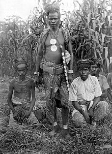
Amarasi was a historical empire in the region. The Raja's residence is in Baun , in the neighboring Westamarasi district.
Economy, infrastructure and transport
Most of the district's residents make a living from agriculture. Cattle (17,920), horses (198), buffalos (15), pigs (14,902), goats (6,416), sheep (2), chickens (40,838) and ducks (63) are kept as pets. Maize is grown on 2901.9 hectares, rice on 140.7 hectares, cassava on 543 hectares, sweet potatoes on 5 hectares and peanuts on 15 hectares. In addition to harvest red onions, garlic, mustard, tomatoes, beans, cucumbers, oranges, bananas, mango, papaya, jackfruit, avocado, pineapple, Soursop , watermelons, coconuts, cocoa, kapok , light nuts , Arecanüsse , coffee, cashew nuts, nutmeg and Tobacco.
In Amarasi there are eleven kindergartens, 20 elementary schools, twelve middle schools and seven secondary schools. A municipal health center ( Puskesmas ) in Nonbes and eight medical care centers ( Puskesmas Pembantu ) are available for medical care . Three doctors, nine midwives and eight nurses work in the district.
49.4 kilometers of roads are paved. 77.5 kilometers of roads are covered with gravel. Simple clay slopes in the district have a length of 84.5 kilometers. Public transport is operated by four minibuses, 66 pick-ups, 29 trucks and 99 motorcycles and one other vehicle.
Web links
- Statistical data from Amarasi District 2018 (Indonesian).
Individual evidence
- ↑ a b c d e f Kecamatan Amarasi Dalam Angka 2018 , accessed on November 3, 2018.
- ↑ Royal Timor: Amarasi ( Memento from November 20, 2008 in the Internet Archive )
