
Ambergris (river)
| Ambergris | ||
 The ambergris at Bucine |
||
| Data | ||
| location | Tuscany region | |
| River system | Arno | |
| Drain over | Arno → Tyrrhenian Sea | |
| River basin district | Appennino Settentrionale | |
| muzzle | At Montevarchi in the Arno coordinates: 43 ° 31 '28 " N , 11 ° 35' 43" E 43 ° 31 '28 " N , 11 ° 35' 43" E
|
|
| length | 38 km | |
| Right tributaries | Lusignana, Trove | |
| Small towns | Montevarchi | |
| Communities | Gaiole in Chianti , Castelnuovo Berardenga , Bucine | |
The Ambra is a 38 km long river in Italy in the Tuscany region . It passes through the provinces of Siena and Arezzo .
course
The ambergris rises on the Monte Luco mountain in the southern municipality of Gaiole in Chianti and initially flows south into the northern municipality of Castelnuovo Berardenga , which it flows through for a total of 6 km. Here the ambergris partly serves as a border with the municipality of Bucine . Near San Gusmè the river turns to the northwest and from here forms the Ambratal (Italian: Val d'Ambra , also written Valdambra ), which in the Middle Ages connected the Senese territory with the Arno valley (Valdarno) and is now known as the provincial road SP 540 (Strada Provinciale , also known as Strada Provinciale Val D'Ambra ) exists. The Lusignana enters from the right near the Badia a Ruoti monastery . The river flows through the village of Ambra (district of Bucine, 258 m ). In Capannole (Bucine, 237 m) the Trove enters from the right . The ambergris then reaches the village of Pogi , a district of Bucine at 226 m, where it meets the Romanesque bridge Ponte Romano di Pogi (restored in 2012, the remains of the historic bridge piers were integrated into the construction). The bridge served as a variant of the Via Cassia from Florence to Rome. Then the river flows east around the main town Bucine to the north. He meets the viaduct Grande viadotto sull'Ambra , a railway bridge built in 1864 for the connection Florence - Rome , which has only been used for regional traffic since the introduction of the Direttissima Firenze-Roma . The bridge withstood several bombs by the Allies during World War II , but was ultimately blown up by the Wehrmacht, which was in retreat, in July 1944. The bridge was rebuilt as early as 1945 and inaugurated a year later. Shortly after the viaduct, the river passes the mills Molino di Bucine (183 mr, also called Molino Benini ) with the medieval bridge ruins and Molino di Mezzo (160 m) and after a total of 25 km in the municipality of Bucine it reaches the town of Levane (district of Bucine as well as Montevarchi ). It now spends 3 km in the municipality of Montevarchi and then enters the Arno as a left tributary .
photos

The Romanesque bridge in Pogi
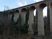
The Grande Viadotto sull'Ambra railway viaduct in Bucine

The bridge ruins near the Molino di Bucine


literature
- Emanuele Repetti: AMBRA (VALLE DELL '). In Dizionario Geografico Fisico Storico della Toscana (1833–1846), online edition of the University of Siena (PDF, Italian)
- Touring Club Italiano : Toscana. Milan 2003, ISBN 88-365-2767-1 , p. 776
Web links
Individual evidence
- ↑ SIRA
- ↑ a b TCI
- ↑ a b c d e f Official website of the ISTAT ( Istituto Nazionale di Statistica ) for the districts in the province of Arezzo (2001), accessed on December 15, 2012 (Italian)
- ↑ Istituto e Museo di Storia della Scienza , accessed on December 15, 2012 (Italian), with illus.
- ^ Official website of the Comune Bucine, accessed on December 15, 2012
- ↑ Sergio Cerri Vestri: Festa a Pogi per il Ponte ritrovato ( Memento of the original from March 4, 2016 in the Internet Archive ) Info: The archive link was inserted automatically and has not yet been checked. Please check the original and archive link according to the instructions and then remove this notice. , La Nazione (Arezzo), June 29, 2012, accessed December 15, 2012
- ↑ Sergio Cerri Vestri
- ↑ Toscagri on the Grande viadotto sull'Ambra bridge ( memento of April 9, 2016 in the Internet Archive ), accessed on December 15, 2012 (Italian), with historical images