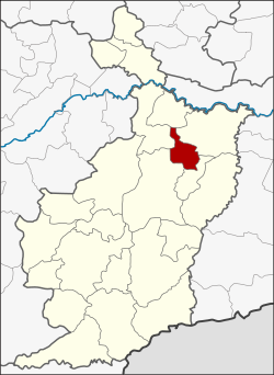
Ban Dan district
|
Ban Dan บ้าน ด่าน |
|
|---|---|
| Province: | Buri Ram |
| Surface: | 247.6 km² |
| Residents: | 30,931 (2013) |
| Population density : | 123.4 U / km² |
| ZIP : | 31000 |
| Geocode : | 3121 |
| map | |

|
|
Ban Dan District ( Thai : อำเภอ บ้าน ด่าน ) is a district ( Amphoe - administrative district) of the province of Buri Ram . The province of Buri Ram is located in the northeast region of Thailand , the so-called Isan .
geography
Neighboring districts (clockwise from north): the Amphoe Khaen Dong , Satuek , Huai Rat , Mueang Buri Ram and Khu Mueang . All Amphoe are in Buri Ram Province.
history
Ban Dan was initially created as a subdistrict ( King Amphoe ) on July 15, 1996 , by separating four tambon from the Mueang Buri Ram district .
On May 15, 2007 the Thai government decided to raise all 81 King Amphoe to simple amphoe status in order to unify the administration. With the publication in the Royal Gazette "Issue 124 chapter 46" on August 24, 2007 this decision officially entered into force.
administration
Provincial Administration
The district of Ban Dan is divided into four tambon ("subdistricts" or "parishes"), which are further divided into 59 muban ("villages").
| No. | Surname | Thai | Muban | Pop. |
|---|---|---|---|---|
| 1. | Ban Dan | บ้าน ด่าน | 20th | 12,340 |
| 2. | Prasat | ปราสาท | 18th | 8,793 |
| 3. | Wang Nuea | วังเหนือ | 12 | 4,299 |
| 4th | Non Khwang | โนน ขวาง | 9 | 5,499 |
Local administration
There are two municipalities with "small town" status ( Thesaban Tambon ) in the district:
- Prasat (Thai: เทศบาล ตำบล ปราสาท )
- Ban Dan (Thai: เทศบาล ตำบล บ้าน ด่าน )
There are also two " Tambon Administrative Organizations " ( องค์การ บริหาร ส่วน ตำบล - Tambon Administrative Organizations, TAO):
- Wang Nuea (Thai: องค์การ บริหาร ส่วน ตำบล วังเหนือ )
- Non Khwang (Thai: องค์การ บริหาร ส่วน ตำบล โนน ขวาง )
Individual evidence
- ↑ ประกาศ กระทรวง มหาดไทย เรื่อง แบ่ง เขต ท้องที่ อำเภอ เมือง บุรีรัมย์ จังหวัด บุรีรัมย์ ตั้ง เป็น กิ่ง อำเภอ บ้าน ด่าน . In: Royal Gazette . 113, No.Special (พิเศษ) 18 ง , June 26, 1996, p. 31.
- ↑ www.manager.co.th
- ↑ พระราชกฤษฎีกา ตั้ง อำเภอ ฆ้องชัย ... และ อำเภอ เหล่า เสือ โก้ ก พ.ศ. ๒๕๕๐ Royal Gazette, Volume 124, Issue 46 ก of August 24, 2007, pp. 14-21 (in Thai)
- ↑ 2013 population statistics ( Thai ) Department of Provincial Administration. Retrieved July 28, 2014.
Web links
Coordinates: 15 ° 6 ' N , 103 ° 10' E
