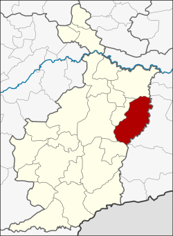
Krasang district
|
Amphoe Krasang อำเภอ กระสัง |
|
|---|---|
| Province: | Buri Ram |
| Surface: | 652.7 km² |
| Residents: | 104,709 (2013) |
| Population density : | 158.03 U./km² |
| ZIP : | 31160 |
| Geocode : | 3103 |
| map | |

|
|
Amphoe Krasang ( Thai : อำเภอ กระสัง ) is a district ( amphoe - administrative district) in the east of the province of Buri Ram . The province of Buri Ram is located in the northeast region of Thailand , the so-called Isan .
geography
Neighboring districts (clockwise from south): Amphoe Phlapphla Chai , Mueang Buri Ram , Huai Rat and Satuek in Buri Ram Province, and Amphoe Mueang Surin in Surin Province .
history
Krasang originally belonged to the Mueang Buri Ram Amphoe , it was named a tambon in 1937 . On April 26, 1952, the three Tambon Krasang, Song Chang and Lamduan were merged, and the subdistrict ( King Amphoe ) Krasang was established. On July 23, 1958, Krasang was promoted to Amphoe.
administration
Provincial Administration
The district of Krasang is divided into 11 tambon ("sub-districts" or "municipalities"), which are further subdivided into 168 muban ("villages").
| No. | Surname | Thai | Muban | Pop. |
|---|---|---|---|---|
| 1. | Krasang | กระสัง | 21st | 15,150 |
| 2. | Lamduan | ลำดวน | 18th | 11,460 |
| 3. | Song Chan | สอง ชั้น | 17th | 12,063 |
| 4th | Sung Noen | สูงเนิน | 19th | 10,872 |
| 5. | Nong Teng | หนอง เต็ง | 18th | 12,210 |
| 6th | Mueang Phai | เมือง ไผ่ | 13 | 7.161 |
| 7th | Chum Saeng | ชุมแสง | 12 | 6,710 |
| 8th. | Ban Prue | บ้าน ปรือ | 15th | 8,916 |
| 9. | Huai Samran | ห้วย สำราญ | 14th | 7.113 |
| 10. | Kanthararom | กันทรารมย์ | 12 | 8,598 |
| 11. | Si Phum | ศรี ภูมิ | 9 | 4,456 |
Local administration
There are four municipalities with "small town" status ( Thesaban Tambon ) in the district:
- Udom Tham (Thai: เทศบาล ตำบล อุดม ธรรม ) consists of the remaining parts of the Tambon Krasang.
- Song Chan (Thai: เทศบาล ตำบล สอง ชั้น ) consists of the entire Tambon Song Chan.
- Nong Teng (Thai: เทศบาล ตำบล หนอง เต็ง ) consists of the entire Tambon Nong Teng.
- Krasang (Thai: เทศบาล ตำบล กระสัง ) consists of parts of the Tambon Krasang.
There are also eight " Tambon Administrative Organizations " ( องค์การ บริหาร ส่วน ตำบล - Tambon Administrative Organizations, TAO):
- Lamduan (Thai: องค์การ บริหาร ส่วน ตำบล ลำดวน )
- Sung Noen (Thai: องค์การ บริหาร ส่วน ตำบล สูงเนิน )
- Mueang Phai (Thai: องค์การ บริหาร ส่วน ตำบล เมือง ไผ่ )
- Chum Saeng (Thai: องค์การ บริหาร ส่วน ตำบล ชุมแสง )
- Ban Prue (Thai: องค์การ บริหาร ส่วน ตำบล บ้าน ปรือ )
- Huai Samran (Thai: องค์การ บริหาร ส่วน ตำบล ห้วย สำราญ )
- Kanthararom (Thai: องค์การ บริหาร ส่วน ตำบล กันทรารมย์ )
- Si Phum (Thai: องค์การ บริหาร ส่วน ตำบล ศรี ภูมิ )
Individual evidence
- ↑ ประกาศ กระทรวง มหาดไทย เรื่อง ยก ฐานะ ตำบล ขึ้น เป็น กิ่ง อำเภอ . In: Royal Gazette . 71, No. 35 ง , June 1, 1958, p. 1314.
- ↑ พระราชกฤษฎีกา จัดตั้ง อำเภอ กระสัง ... . In: Royal Gazette . 75, No. 55 ก , July 22, 1958, pp. 321-327.
- ↑ 2013 population statistics . Department of Provincial Administration. Retrieved July 25, 2014.
Web links
Coordinates: 14 ° 55 ' N , 103 ° 18' E
