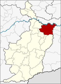
Amphoe Satuek
|
Amphoe Satuek อำเภอ สตึก |
|
|---|---|
| Province: | Buri Ram |
| Surface: | 803.0 km² |
| Residents: | 111,519 (2013) |
| Population density : | 137.0 U / km² |
| ZIP : | 31150 |
| Geocode : | 3111 |
| map | |

|
|
Amphoe Satuek ( Thai : อำเภอ สตึก ) is a district ( amphoe - administrative district) in the northeast of Buri Ram Province . The province of Buri Ram is located in the northeast region of Thailand , the so-called Isan .
geography
Neighboring districts (from the south clockwise): the Amphoe Krasang , Huai Rat , Ban Dan , Khu Mueang and Khaen Dong of the province Buri Ram and the Amphoe Chumphon Buri , Tha Tum , Chom Phra and Mueang Surin in the province Surin .
history
Satuek was originally a tambon of the Amphoe Mueang Buri Ram , in 1938 he was appointed to a "branch circle" ( King Amphoe ) . On November 1, 1947, Satuek was promoted to Amphoe.
administration
Provincial Administration
The district of Satuek is divided into twelve tambon ("sub-districts" or "municipalities"), which are further subdivided into 179 muban ("villages").
| No. | Surname | Thai | Muban | Pop. |
|---|---|---|---|---|
| 1. | Satuek | สตึก | 15th | 14,395 |
| 2. | Nikhom | นิคม | 24 | 16,442 |
| 3. | Thung Wang | ทุ่ง วัง | 15th | 8,234 |
| 4th | Mueang Kae | เมือง แก | 19th | 11,053 |
| 5. | Nong Yai | หนองใหญ่ | 16 | 9,305 |
| 6th | Ron Thong | ร่อนทอง | 18th | 11,674 |
| 9. | Don Mon | ดอน มนต์ | 10 | 5,585 |
| 10. | Chum Saeng | ชุมแสง | 18th | 10,387 |
| 11. | Tha Muang | ท่าม่วง | 11 | 6,074 |
| 12. | Sakae | สะแก | 13 | 7,246 |
| 14th | Sanam Chai | สนาม ชัย | 12 | 6,413 |
| 15th | Krasang | กระสัง | 8th | 4,711 |
Note: The missing numbers (geocodes) belong to the tambon that belong to the Amphoe Khaen Dong today .
Local administration
There are four municipalities with "small town" status ( Thesaban Tambon ) in the district:
- Si Satuek (Thai: เทศบาล ตำบล ศรี สตึก )
- Don Mon (Thai: เทศบาล ตำบล ดอน มนต์ )
- Sakae (Thai: เทศบาล ตำบล สะแก )
- Satuek (Thai: เทศบาล ตำบล สตึก )
There are also nine " Tambon Administrative Organizations " ( องค์การ บริหาร ส่วน ตำบล - Tambon Administrative Organizations, TAO):
- Nikhom (Thai: องค์การ บริหาร ส่วน ตำบล นิคม )
- Thung Wang (Thai: องค์การ บริหาร ส่วน ตำบล ทุ่ง วัง )
- Mueang Kae (Thai: องค์การ บริหาร ส่วน ตำบล เมือง แก )
- Nong Yai (Thai: องค์การ บริหาร ส่วน ตำบล หนองใหญ่ )
- Ron Thong (Thai: องค์การ บริหาร ส่วน ตำบล ร่อนทอง )
- Chum Saeng (Thai: องค์การ บริหาร ส่วน ตำบล ชุมแสง )
- Tha Muang (Thai: องค์การ บริหาร ส่วน ตำบล ท่าม่วง )
- Sanam Chai (Thai: องค์การ บริหาร ส่วน ตำบล สนาม ชัย )
- Krasang (Thai: องค์การ บริหาร ส่วน ตำบล กระสัง )
Individual evidence
- ↑ 2013 population statistics . Department of Provincial Administration. Retrieved July 25, 2014.
Web links
Coordinates: 15 ° 18 ' N , 103 ° 18' E
