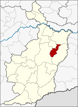
Huai Rat district
|
Huai Council ห้วย ราช |
|
|---|---|
| Province: | Buri Ram |
| Surface: | 182.12 km² |
| Residents: | 37,053 (2013) |
| Population density : | 199 U / km² |
| ZIP : | 31000 |
| Geocode : | 3116 |
| map | |

|
|

Huai Rat District ( Thai : อำเภอ ห้วย ราช ) a district is ( Amphoe - administrative district) of the province of Buri Ram . The province of Buri Ram is located in the northeast region of Thailand , the so-called Isan .
geography
Neighboring districts (clockwise from the east): the Amphoe Krasang , Mueang Buri Ram , Ban Dan and Satuek . All Amphoe are in Buri Ram Province.
history
Huai Council was set up on April 1, 1990, initially as a "branch circle" ( King Amphoe ) , by separating the five Tambon Huai Council, Sam Waeng, Ta Sao, Ban Tako and Sanuan from the Mueang Buri Ram district . On September 8, 1995, Huai Rat was promoted to Amphoe.
administration
Provincial Administration
Huai Rat County is divided into eight tambon ("subdistricts" or "parishes"), which are further subdivided into 80 muban ("villages").
| No. | Surname | Thai | Muban | Pop. |
|---|---|---|---|---|
| 1. | Huai Council | ห้วย ราช | 10 | 4,534 |
| 2. | Sam Waeng | สาม แวง | 9 | 4,344 |
| 3. | Ta Sao | ตา เสา | 10 | 4,937 |
| 4th | Ban Tako | บ้าน ตะโก | 9 | 3,367 |
| 5. | Sanuan | สนวน | 12 | 5,478 |
| 6th | Khok Lek | โคก เหล็ก | 11 | 6,356 |
| 7th | Mueang Pho | เมือง โพธิ์ | 9 | 3,824 |
| 8th. | Huai Racha | ห้วย ราชา | 10 | 4.213 |
Local administration
There are three municipalities with "small town" status ( Thesaban Tambon ) in the district:
- Sam Waeng (Thai: เทศบาล ตำบล สาม แวง )
- Khok Lek (Thai: เทศบาล ตำบล โคก เหล็ก )
- Huai Rat (Thai: เทศบาล ตำบล ห้วย ราช )
There are also five " Tambon Administrative Organizations " ( องค์การ บริหาร ส่วน ตำบล - Tambon Administrative Organizations, TAO):
- Huai Rat (Thai: องค์การ บริหาร ส่วน ตำบล ห้วย ราช )
- Ta Sao (Thai: องค์การ บริหาร ส่วน ตำบล ตา เสา )
- Ban Tako (Thai: องค์การ บริหาร ส่วน ตำบล บ้าน ตะโก )
- Sanuan (Thai: องค์การ บริหาร ส่วน ตำบล สนวน )
- Mueang Pho (Thai: องค์การ บริหาร ส่วน ตำบล เมือง โพธิ์ )
Individual evidence
- ↑ ประกาศ กระทรวง มหาดไทย เรื่อง แบ่ง เขต ท้องที่ อำเภอ เมือง บุรีรัมย์ จังหวัด บุรีรัมย์ ตั้ง เป็น กิ่ง อำเภอ ห้วย ราช . In: Royal Gazette . 107, No. 25 ง , February 13, 1999, p. 1353.
- ↑ พระราชกฤษฎีกา ตั้ง อำเภอ ด่าน มะขาม เตี้ย อำเภอ แก่ง หาง แมว อำเภอ ภักดี ชุมพล อำเภอ เวียง แก่น อำเภอ แม่ วาง อำเภอ ถ้ำ พรรณ รา อำเภอ บ่อ เกลือ อำเภอ อำเภอ โนน สุวรรณ อำเภอ ห้วย ราช อำเภอ แม่ ลาน อำเภอ บางแก้ว อำเภอ ป่า พะยอม อำเภอ หนอง ม่วง ไข่ สุ ราช สี สี สี สี สี สี สี อำเภอ จัง หาร อำเภอ บ้าน ธิ อำเภอ ภู สิงห์ อำเภอ บาง กล่ำ อำเภอ วัง ม่วง และ อำเภอ นา ยูง พ.ศ. ๒๕๓๘ . In: Royal Gazette . 112, No. 32 ก , August 8, 1995, pp. 1-3.
- ↑ 2013 population statistics . Department of Provincial Administration. Retrieved July 25, 2014.
Web links
Coordinates: 14 ° 58 ' N , 103 ° 11' E
