Armiñon
| Armiñon municipality | ||
|---|---|---|
 Armiñon with Río Zadorra
|
||
| coat of arms | Map of Spain | |

|
|
|
| Basic data | ||
| Autonomous Community : |
|
|
| Province : | Álava | |
| Comarca : | Cuadrilla de Añana | |
| Coordinates | 42 ° 43 ′ N , 2 ° 52 ′ W | |
| Height : | 475 msnm | |
| Area : | 12.94 km² | |
| Residents : | 227 (Jan 1, 2019) | |
| Population density : | 17.54 inhabitants / km² | |
| Postal code : | 01220 | |
| Municipality number ( INE ): | 01006 | |
| administration | ||
| Website : | Armiñon | |
Armiñon is a place and a municipality in northern Spain with 227 inhabitants (as of January 1, 2019) in the south of the province of Álava in the Basque Country . The place is on a branch of the Way of St. James ( Camino Francés ) coming from San Sebastian .
Location and climate
The place Armiñon lies on the east bank of the Río Zadorra at an altitude of approx. 475 m . The provincial capital Vitoria-Gasteiz is about 30 km (driving distance) northeast; the town of Miranda de Ebro in Castile is only 12 km southwest. The climate is temperate to warm; Rain (approx. 750 mm / year) falls over the year.
Population development
| year | 1857 | 1900 | 1950 | 2000 | 2017 |
| Residents | 617 | 374 | 347 | 146 | 239 |
As a result of by the mechanization of agriculture farming and the abandonment small businesses caused rural exodus , the population declined since the end of the 19th century continuously and on. The municipality also includes the village (aldea) Estavillo and the hamlet (pedanía) Lacorzana .
economy
For centuries, the residents of the community lived on agriculture, self-sufficient , in which cattle breeding played an essential role. Gradually, handicrafts, trade and smaller service companies developed. Today there are commercial settlements at the gates of the village.
history
Celts , Romans , Visigoths and Moors left no archaeologically usable traces, but the place was on a Roman road leading from Astorga (Asturica Augusta) via Agurain to Bordeaux (Burdigala) . The region has belonged to the Emirate of Cordoba since 756 ; after the reconquest ( reconquista ) by the Christians in 824, the area belonged to the Kingdom of Pamplona , from which the Kingdom of Navarre later emerged. The place is first mentioned under the name Aramignon around the year 1025 in a document from the monastery of San Millán de la Cogolla . Alfonso VIII of Castile conquered western Navarre around 1200. Armiñon itself was granted privileges ( fueros ) by King Sancho IV of Castile in 1274 .
Attractions
- The oldest structure in the village is the sechsbogige - perhaps originally Roman, but always renewed - bridge over the Río Zadorra, which later also by the Jacob pilgrims was used.
- The medieval Iglesia de San Andrés was later supplemented with components from the Renaissance and Baroque periods .
- The Palacio del Marques de Terán, with its stone heraldic shields, dates from the 17th century .
- Surroundings
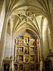
- The Iglesia de San Martín in the village of Estavillo , a good 1 km to the north-east and already mentioned in a document in 871 , has a beautiful portal in the late Gothic style with several archivolts and a keel arch that covers everything . The nave (nature) is star-curved ; in the flat closed vestibule is an imposing Altarretabel (retablo) from the Renaissance period with many figures.
- In the hamlet of Lacorzana there is a late medieval defense tower that belonged to the noble landlord family Hurtado de Mendoza .
Web links
- Armiñon - Tourism site (Spanish)
Individual evidence
- ↑ Cifras oficiales de población resultantes de la revisión del Padrón municipal a 1 de enero . Population statistics from the Instituto Nacional de Estadística (population update).
- ↑ Armiñon - climate tables
- ↑ Armiñon - population development
- ↑ Armiñon - History
- ↑ Armiñon Bridge
- ↑ Armiñon - Estavillo
- ↑ Armiñon - Lacorzada
← Previous location: Zalduondo | Armiñon | Next town: Vitoria-Gasteiz →


