Astrup (Wardenburg)
|
Astrup
Municipality Wardenburg
Coordinates: 53 ° 2 ′ 46 ″ N , 8 ° 13 ′ 56 ″ E
|
|
|---|---|
| Height : | 7 m above sea level NN |
| Postal code : | 26203 |
| Area code : | 04407 |
|
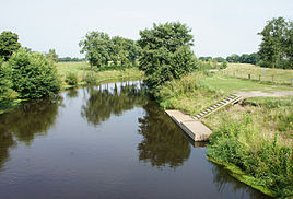
The Hunte at Astrup with a placement point for canoes
|
|
Astrup is a town in the municipality of Wardenburg in north-west Lower Saxony with a distinct village and rural character.
geography
Geographical location
Astrup is located on a Geestzipfel west of the Hunte and south-east of the municipality of Wardenburg. To the north and east, the Griesenmoor and the Hunte form a natural border, in the west Astrup extends to the state forest Tüdick .
geology
The landscape is characterized by the Hunten lowlands and Geest locations. The predominant forest type is the oak-birch forest on dune locations. Other soil areas originate from the Vistula glaciation and are characterized by fine, medium and coarse sands (fluvial deposits). The water table is often less than 5 m and is only covered by sand.
history
In the 8th century the first settlers settled in Astrup, which was formerly called Adestorpe, because of the good Eschland and the Hunteweiden and cultivated the land. Due to its remote location - earlier trade routes between Oldenburg , the Münsterland , Bremen and Wildeshausen passed Astrup - the village led a quiet existence for a long time. The Hunte represented a border until the 20th century, as it could only be crossed over fords in dry summers . Nevertheless, Astrup was not spared from some conflicts.
In the 15th and 16th centuries, the Counts of Oldenburg were often in conflict with the Bishop of Münster and the Count of Hoya , and the surrounding towns were often affected. So z. B. in 1454, when Astrup was devastated. Or on the edge of the feud between the Count of Oldenburg and the Bishop of Münster in 1538: When the Oldenburgs were on the retreat, the Münster army moved through the village and set farms and fields on fire.
At the time of the Thirty Years' War in 1623 the army of Count von Tilly stayed in Wardenburg and the soldiers roamed and plundered Astrup.
The increase in population from the second half of the 18th century meant that the nasties were distributed. In Astrup, the commons in 1824 meant that the nine Brinkitzers were able to secure their livelihoods on site and were no longer dependent on going to Holland . The land consolidation procedure carried out in 1976/77 resulted in further changes in the townscape and the division of the land.
The district of Hohensand has existed since 1937 with an area of 6.7 ha , which is primarily designed as a single-family housing estate.
After the dike broke in March 1981, large parts of Astrup were flooded, which led to the Hunting dike being raised and fortified on the local side.
The only pub, the Astruper Krug, was closed in 1992.
Population development
The data up to 1895 were collected by censuses.
| year | Residents |
|---|---|
| 1762 | 204¹ |
| 1785 | 193¹ |
| 1793 | 237¹ |
| 1895 | 115 |
| May 27, 1970 | 243 |
| December 31, 1980 | 223 |
| December 31, 1990 | 182 |
| December 31, 2000 | 230 |
| December 31, 2005 | 238 |
¹ Including the Höven district
Culture and sights
Clubs etc.
The only association is the Astrup / Hohensand citizens' association, which was founded in 1976. A folk dance group existed until 1980.
Buildings
- Astrup sheepfold
Natural monuments
Over 50% of the local area are designated as landscape protection areas or forest areas, including
- Griesenmoor as a natural monument
- Conservation area Hunte
Regular events
- May Day with maypole setting
- Open day at the Astrup sheepfold on Ascension Day / Father's Day
- Thanksgiving
Economy and Infrastructure
traffic
Astrup is connected to the regional transport network with Landesstraße 870 and Kreisstraße 149 and 242.
A significant change in the appearance of the village resulted from the construction of the federal motorway 29 and the two motorway service stations Huntetal West and East from 1980. The motorway has since divided the village into two parts.
Trade / agriculture
Astrup was originally a purely farming village with arable and pasture areas. A 23 hectare industrial area has been designated in Astrup since 1992 (Astrup industrial area) and another is being planned (Rothenschlatt industrial area). Agriculture has been declining ever since. In 1970 there were twelve full-time farms, in 1995 there were only three.
education
In 1840 the first school for the children from Höven and Astrup was built in Astrup, where they taught for 71 years. In 1911 a new school was built, which was used until 1962. Then several schools in the Wardenburg villages were merged and the children from Astrup have been attending the Hohenfelde elementary school ever since . For secondary schools, the children have to visit the schools in Wardenburg and Oldenburg.

