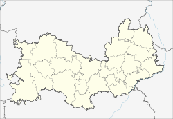
Atjaschewo (Mordovia)
Urban-type settlement
|
||||||||||||||||||||||||||||||
|
||||||||||||||||||||||||||||||
|
||||||||||||||||||||||||||||||
Atjaschewo ( Russian Атя́шево ; ersjanisch Отяжвеле ) is an urban-type settlement in the Republic of Mordovia in Russia with 6246 inhabitants (as of October 14, 2010).
geography
The place is about 75 km as the crow flies northeast of the republic capital Saransk .
Atjaschewo is the administrative center of Atjaschewski Rajons and the seat and only locality of the municipality Atjaschewskoje gorodskoje posselenije.
history
The place was created in 1894 in connection with the construction of the railway line to Kazan , when a station was built there and named after the village two kilometers to the west.
On July 16, 1928, the station settlement Atjaschewo became the administrative seat of a newly created Rajon. In 1963 the place received urban-type settlement status.
Population development
| year | Residents |
|---|---|
| 1939 | 1213 |
| 1959 | 1581 |
| 1970 | 3891 |
| 1979 | 4393 |
| 1989 | 6298 |
| 2002 | 6073 |
| 2010 | 6246 |
Note: census data
traffic
Atjaschewo has a train station at kilometer 125 of the Rusajewka - Kanasch line, which opened in 1894 as part of the first rail link to Kazan .
The regional road 89K-06 runs through the settlement, which branches off the R178 Saransk - Ulyanovsk at Komsomolski and continues via Ardatow and Turgenewo to the border of the Udmurt Republic in the direction of Alatyr . In a south-easterly direction there is also a connection to the R178 via the 89N-03 to the neighboring Rajon center Dubjonki , about 25 km away .
Web links
Individual evidence
- ↑ a b Itogi Vserossijskoj perepisi naselenija 2010 goda. Tom 1. Čislennostʹ i razmeščenie naselenija (Results of the All-Russian Census 2010. Volume 1. Number and distribution of the population). Tables 5 , pp. 12-209; 11 , pp. 312–979 (download from the website of the Federal Service for State Statistics of the Russian Federation)

