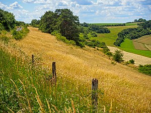
On the Pottschütthöhe
|
On the Pottschütthöhe
IUCN category none - not specified |
||
|
North slope of the NSG Pottschütthöhe |
||
| location | Rhineland-Palatinate , Germany | |
| surface | 93 ha | |
| WDPA ID | 318140 | |
| Geographical location | 49 ° 16 ' N , 7 ° 29' E | |
|
|
||
| Setup date | 2003 | |
The nature reserve Auf der Pottschütthöhe is located in the district of Südwestpfalz in Rhineland-Palatinate .
The approximately 93 hectare area, which was placed under nature protection in 2003 , extends northwest of the local community Rieschweiler-Mühlbach . State road 466 runs to the east and state road 477 to the south . Not far to the west is the Am Gödelsteiner Hang nature reserve and not far to the east is the Auf dem Hausgiebel nature reserve .
The purpose of protection is the preservation, development and restoration of limestone grasslands in particular, as well as extensive grassland and the preservation of woody plants, hedges , forest and fringe areas typical of the location as locations of typical, rare or threatened plant species and plant communities and as habitats and partial habitats more typical, rarer , partly endangered wild animal species as core areas of a networked biotope system of the limestone grasslands of the Zweibrücken hill country because of their special character and beauty as well as for scientific reasons.
See also
Web links
- World Database on Protected Areas - Auf der Pottschütthöhe (English)
- 340-211 Ordinance on the nature reserve "Auf der Pottschütthöhe" district of Südwestpfalz from June 10, 2003 (PDF) on naturschutz.rlp.de
- Claudia Endres, Karin Feick-Müller, Jürgen Walter: NSG-ALBUM on the Pottschütthöhe NSG7340-211. (PDF) State Office for the Environment, Rhineland-Palatinate, December 2019, accessed on June 28, 2020 .


