
Altenburg – Langenleuba-Oberhain railway line
| Abzw Nobitz – Langenleuba-Oberhain | |||||||||||||||||||||||||||||||||||||||||||||||||||||||||||||||||||||||||||||||||||||||||||||||||||||||||||||||||||||||||||||||||||||
|---|---|---|---|---|---|---|---|---|---|---|---|---|---|---|---|---|---|---|---|---|---|---|---|---|---|---|---|---|---|---|---|---|---|---|---|---|---|---|---|---|---|---|---|---|---|---|---|---|---|---|---|---|---|---|---|---|---|---|---|---|---|---|---|---|---|---|---|---|---|---|---|---|---|---|---|---|---|---|---|---|---|---|---|---|---|---|---|---|---|---|---|---|---|---|---|---|---|---|---|---|---|---|---|---|---|---|---|---|---|---|---|---|---|---|---|---|---|---|---|---|---|---|---|---|---|---|---|---|---|---|---|---|---|
 | |||||||||||||||||||||||||||||||||||||||||||||||||||||||||||||||||||||||||||||||||||||||||||||||||||||||||||||||||||||||||||||||||||||
| Route number : | 6816; sä. Al | ||||||||||||||||||||||||||||||||||||||||||||||||||||||||||||||||||||||||||||||||||||||||||||||||||||||||||||||||||||||||||||||||||||
| Course book section (DB) : | 534 (1995) | ||||||||||||||||||||||||||||||||||||||||||||||||||||||||||||||||||||||||||||||||||||||||||||||||||||||||||||||||||||||||||||||||||||
| Route length: | 20.97 km | ||||||||||||||||||||||||||||||||||||||||||||||||||||||||||||||||||||||||||||||||||||||||||||||||||||||||||||||||||||||||||||||||||||
| Gauge : | 1435 mm ( standard gauge ) | ||||||||||||||||||||||||||||||||||||||||||||||||||||||||||||||||||||||||||||||||||||||||||||||||||||||||||||||||||||||||||||||||||||
| Maximum slope : | 10 ‰ | ||||||||||||||||||||||||||||||||||||||||||||||||||||||||||||||||||||||||||||||||||||||||||||||||||||||||||||||||||||||||||||||||||||
| Minimum radius : | 300 m | ||||||||||||||||||||||||||||||||||||||||||||||||||||||||||||||||||||||||||||||||||||||||||||||||||||||||||||||||||||||||||||||||||||
| Top speed: | 50 km / h | ||||||||||||||||||||||||||||||||||||||||||||||||||||||||||||||||||||||||||||||||||||||||||||||||||||||||||||||||||||||||||||||||||||
|
|||||||||||||||||||||||||||||||||||||||||||||||||||||||||||||||||||||||||||||||||||||||||||||||||||||||||||||||||||||||||||||||||||||
| Abzw Stünzhain – Abzw Paditz | |||||||||||||||||||||||||||||||||||||||||||||||||||||||||||||||||||||||||||||||||||||||||||||||||||||||||||||||||||||||||||||||||||||
| Route number : | 6818 | ||||||||||||||||||||||||||||||||||||||||||||||||||||||||||||||||||||||||||||||||||||||||||||||||||||||||||||||||||||||||||||||||||||
| Gauge : | 1435 mm ( standard gauge ) | ||||||||||||||||||||||||||||||||||||||||||||||||||||||||||||||||||||||||||||||||||||||||||||||||||||||||||||||||||||||||||||||||||||
|
|||||||||||||||||||||||||||||||||||||||||||||||||||||||||||||||||||||||||||||||||||||||||||||||||||||||||||||||||||||||||||||||||||||
The Altenburg – Langenleuba – Oberhain line was a branch line in Thuringia and Saxony . It ran from Altenburg to Langenleuba-Oberhain to connect to the Rochlitz – Penig connection . In 1998 the line was closed.
history
The Altenburg-Zeitzer railway company , founded in 1870, had planned a connection from Altenburg in the direction of Narsdorf to connect to the Kieritzsch – Chemnitz line in order to open up new sales areas for the lignite mined in the Altenburger Land . The project was only realized under the direction of the Kgl. Saxon State Railways as a standard gauge secondary railway . Work on the new line began in September 1899. In order to cross the valleys, it was necessary to build several larger viaducts, almost all of which were made with the then new material concrete . The viaducts were built by Beton- und Monierbau AG. The new lift opened on June 15, 1901.
In 1909, Prof. Dr.-Ing. Barkhausen-Hanover, on behalf of August Scherl, provided an expert opinion on the conversion into a gyro-stabilized monorail in order to prove the financial feasibility of such a railway. This report showed that the monorail route would be one kilometer shorter than the existing route due to its smaller curve radii and greater gradients. In addition, the cost of a monorail would be 57% lower. Since this report was only intended to show theoretically that such a monorail is economically feasible, this project was never implemented.
After the political change in eastern Germany in 1989, the line quickly lost its importance in passenger and freight traffic. In view of several defective bridges - for which renewal was no longer an option for reasons of profitability - train traffic over the entire route was stopped at the timetable change on May 27, 1995. Initially, only the connecting line to Altenburg Airport remained in operation and continued to be used for freight traffic.
On June 2, 1998 the closure of the Ehrenhain – Langenleuba-Oberhain (–Narsdorf) section was approved by the Federal Railway Authority. It was legally enforced on August 15, 1998. On December 31, 1999, the remainder of the route between Nobitz and Ehrenhain was given up after freight traffic had been suspended since June 21.
The road bridge over the railway line on the road between Beiern and Langenleuba-Niederhain no longer exists. The bridge was demolished at the end of 2007 and the winding road was straightened by extensive earthworks. The route was completely removed and built over in this area. The road bridge on State Road 57 was also dismantled, the course of the road in this area straightened and the railway line completely built over. The bridge over State Road 51 no longer exists.
The Thuringian section of the route has been owned by the NABU Foundation National Natural Heritage since 2016 and is intended to serve as a connection between various biotopes for butterflies, dormice and dormice. The viaducts are still owned by Deutsche Bahn, but are leased by the Viaduktradweg association , which was formed in 2012 from the previous citizens' initiative. For reasons of cost, the cycle path is initially to be given a sand-filled gravel surface; the application of an asphalt layer at a later date remains an option. The construction of the eight-kilometer section from Kotteritz to Ehrenhain will cost 300,000 euros.
After a free cut in February 2018, the application of the sand began. Due to concerns of the district office, the construction was interrupted in June and a species protection examination was carried out. However, this did not reveal any threat to rare animal species.

Bridge over the S 57 at the Niedersteinbach exit

Steinbach Viaduct

Detail at the Steinbach Viaduct

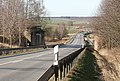
former bridge over the S 57 between Niedersteinbach and Wernsdorf
dismantled bridge over the S 51


Route description
course

The railway branched off from the Leipzig – Hof railway line at Nobitz station . This is due to the Pleiße . After crossing a flood bridge, the connecting arch from the direction of Gößnitz from the Leipzig-Hof railway line turned from the right . Then a siding branched off to Altenburg Airport . At the station Ehrenhain which was federal highway 180 crossed. One kilometer behind the station, the line passed the Nirkendorf viaduct . The next viaduct named Viadukt Frohnsdorf (Wiesebach viaduct ) was reached after the Wiesebach stop . He spanned the valley of the Wiera . This was followed by the Beiern-Langenleuba station and then the Beiern bridge and the Heidelbergsmühle viaduct . Behind it lay the Thuringia-Saxony state border since 1952 (at that time only the district border between the Altenburg and Geithain districts). Until 1952 it was behind the next station Steinbach im Steinbach, which was crossed by the Steinbach viaduct . Behind the station Wernsdorf (b Penig) the line turned into the Rochlitz – Penig railway line . Then the terminus Langenleuba-Oberhain was reached. This is located near the federal highway 175 . The parallel federal motorway 72 was only opened after the railway line was closed.
Operating points
Altenburg ⊙
.jpg)
Initially, Altenburg was a terminus on the Leipzig – Hof railway line , as it was not possible to continue directly to the south with the technical means available at the time. Instead, the city was originally bypassed to the east in the further course. The Altenburgers had pushed through the junction as close to the city as possible, as later with a direct connecting curve some trains would no longer have stopped in Altenburg.
Since the terminus on today's Fabrikstrasse became more and more an obstacle to operations, a change was planned since 1871. Instead of a connecting curve that was initially planned, Altenburg received a new train station, and the ridge to the south of it was crossed with a tunnel. The new station was completed in 1878 after two years of construction. Altenburg station had the following names:
- until 1936: Altenburg
- until 1942: Altenburg (Thür)
- until 1953: Altenburg (Thür) Hbf
- since 1953: Altenburg
The now closed railway lines to Zeitz and Langenleuba-Oberhain branched off at Altenburg station from 1872 and 1901, respectively.
Wilchwitz ⊙
The Wilchwitz stop was west of the village of Wilchwitz on the Leipzig – Hof railway line. He has since been abandoned.
Nobitz ⊙

Nobitz station was built on June 15, 1901 as the Kotteritz stop at the branch of the railway line to Langenleuba-Oberhain from the Leipzig – Hof railway line, which opened in 1844 . In 1905 it was appointed station and in 1959 it was renamed Nobitz . The station went out of service with the closure of the line on May 27, 1995. It is located between Nobitz in the east and the village of Kotteritz an der Pleiße, which was incorporated in 1960 . The station building, the farm building, the scales and the goods shed are still there. The B1 signal box was demolished in 2013. The reception building is owned by the NABU Foundation and is to be reused.
Klausa ⊙
.jpg)
The Klausa halt was opened on June 15, 1901. It was located west of the eponymous place Klausa on the way to Hauersdorf . The station served the briquette factory built in the neighboring town of Garbus and the Winterfeld lignite mine as a loading station. On May 27, 1995, the breakpoint went out of service with the cessation of passenger traffic.
Grove of Honor ⊙
.jpg)
The Ehrenhain stop was opened on June 15, 1901 and became a train station in 1905. The station, which is located in the north of Ehrenhain , went out of service when the line was closed on May 27, 1995. The reception building, the farm building and the goods shed are still there.
Boderitz (Kr Altenburg) ⊙
The Boderitz i. S.-A. opened on June 15, 1901 and upgraded to a station in 1905. The station had the following names:
- until 1911: Boderitz i. S.-A.
- until 1922: Boderitz (S-Altenbg)
- since 1922: Boderitz (Kr Altenburg)
In 1933 it was downgraded to a stop. On May 27, 1995, the breakpoint went out of service with the cessation of passenger traffic. The former train station is located between Boderitz in the north and Uhlmannsdorf in the south. The reception building, the residential building, the goods shed and the farmhouse have all been preserved and partially restored.

Boderitz stop (Kr Altenburg), reception building (2017)

Boderitz stop (Kr Altenburg), goods shed (2017)

Boderitz stop (Kr Altenburg), residential building (2017)
_Empfangsgeb%C3%A4ude_(3).jpg)
_G%C3%BCterschuppen_(1).jpg)
_Wohnhaus.jpg)
Wiesebach ⊙
.jpg)
The Wiesebach stop was opened on June 15, 1901 with the Altenburg – Langenleuba – Oberhain railway line. He owned a wooden waiting room and was located northwest of the village of Wiesebach, which today belongs to Frohnsdorf . The Wiesebacher Viaduct was reached about one kilometer behind the halt in the direction of Langenleuba-Oberhain. With the cessation of passenger traffic on May 27, 1995, the stop went out of service.
Beiern – Langenleuba ⊙

The Beiern – Langenleuba stop was opened on June 15, 1901 for the towns of Beiern and Langenleuba-Niederhain , and in 1905 it was named a train station. The station, which is located in the town of Beiern south of Langenleuba-Niederhain, went out of service when the line was closed on May 27, 1995. The ensemble of reception building, railway maintenance office, farm building, water station, platform scales and goods shed is still there.
Steinbach (Kr Geithain) ⊙

The breakpoint in the Niedersteinbach district , which today belongs to Penig , reflects the political situation in the area. The Steinbach flowing through the towns of Obersteinbach and Niedersteinbach formed the political border between Saxony and Saxony-Altenburg and Thuringia until 1952. Since the station opened on June 15, 1901, was west of the Steinbach and thus in the Duchy of Saxony-Altenburg , it was given the name of Steinbach, which was formed in 1855 from the Saxon-Altenburg parts of Obersteinbach and Niedersteinbach. The station, which was named a train station in 1905, then bore the following names:
- until 1911: Steinbach i. S.-A.
- until 1922: Steinbach (S-Altenbg) (The station was in the Free State of Saxony-Altenburg from 1918 and in the State of Thuringia from 1920)
With the administrative reform in the state of Thuringia, Steinbach had been in the Altenburg district since 1922 , so the station was renamed Steinbach (Kr Altenburg) that year . In 1933 it was downgraded to a stop.
Due to the administrative reform in the GDR in 1952, Steinbach was assigned to the Altenburg district in the Leipzig district in July 1952 . In December it was assigned to the Geithain district in the Leipzig district. After the political unification of the former Saxon parts of Obersteinbach and Niedersteinbach with Wernsdorf and the former Thuringian Steinbach was completed in January 1953, the breakpoint was given the name Steinbach (Kr Geithain) in 1954 , which was also changed after the municipality was renamed "Niedersteinbach “Was preserved in 1956. The stop went out of service on May 27, 1995. The wooden waiting hall of the stop is still there. It is located on "Altenburger Straße" in the west of the town.
Wernsdorf (b Penig) ⊙

The Wernsdorf near Penig stop was opened on June 15, 1901 with the Altenburg – Langenleuba – Oberhain railway line. In 1905 it was upgraded to a station and in 1933 it was dedicated to a stop. The station had the following names:
- until 1911: Wernsdorf near Penig
- until 1933: Wernsdorf b Penig
- since 1933: Wernsdorf (b Penig)
With the cessation of passenger traffic on May 27, 1995, the stop went out of service. It is located northeast of the village between the roads to Langenleuba-Oberhain and federal highway 175 . The high-rise buildings, including the wooden bus shelter, were demolished.
Langenleuba-Oberhain ⊙

The Langenleuba stop was opened on April 8, 1872 with the Rochlitz – Narsdorf – Penig railway line. In 1901 it was renamed Langenleuba-Oberhain and in 1905 it was upgraded to a station. Since 1901 the station was the end of the Altenburg – Langenleuba – Oberhain railway line. With the suspension of travel on the Narsdorf – Penig section, Langenleuba-Oberhain station became an unoccupied stop on May 26, 1990. After the tourist traffic on the railway line to Altenburg was stopped on May 27, 1995, the station is out of service. It is located east of the elongated place. The federal highway 175 and the newly built federal highway 72 are in the immediate vicinity .
See also
literature
- Erich Preuß , Reiner Preuß : Saxon State Railways . transpress Verlagsgesellschaft, Berlin 1991, ISBN 3-344-70700-0 .
Web links
Individual evidence
- ^ Lit. Deutsche Bauzeitung, Volume 39, September 1905, page 7, Verlag E. Toeche
- ^ August Scherl: A new rapid transit system - addendum . Berlin 1910, pp. 73ff
- ↑ List of federally closed lines in the state of Saxony that have been closed since 1994. (EXL; 27 kB) (No longer available online.) August 21, 2012, archived from the original on September 24, 2015 ; Retrieved January 6, 2013 . Info: The archive link was inserted automatically and has not yet been checked. Please check the original and archive link according to the instructions and then remove this notice.
- ↑ A hiking trail for nature - bought the embankment near Altenburg. NABU Foundation for National Natural Heritage, September 6, 2016, accessed December 7, 2017 .
- ^ Embankment near Altenburg. NABU Foundation for National Natural Heritage, accessed December 7, 2017 .
- ↑ Jörg Reuter: Viaduktradweg: Association draws mixed results. In: Leipziger Volkszeitung. Retrieved December 7, 2017 .
- ↑ Jörg Reuter: The license to collect donations - The Citizens' Initiative Viaduktradweg transforms into an association. In: Leipziger Volkszeitung. February 15, 2012, accessed December 7, 2017 .
- ↑ Jörg Reuter: Road surface - Viaduktradwegverein gives preference to a gravel surface covered with sand. In: Leipziger Volkszeitung. July 14, 2017. Retrieved December 7, 2017 .
- ↑ Jörg Reuter: Viaduktradweg: The next construction phase costs 300,000 euros. In: Leipziger Volkszeitung. Retrieved December 7, 2017 .
- ↑ Jörg Reuter: A lot achieved: First work assignment is a success. In: Leipziger Volkszeitung. February 22, 2018, accessed November 15, 2018 .
- ↑ Jens Rosenkranz: Species protection not checked: Naturschutzbund must stop construction. In: Leipziger Volkszeitung. June 18, 2018, accessed November 15, 2018 .
- ↑ a b Jörg Reuter: Plans for the old Kotteritz train station are becoming more concrete. In: Leipziger Volkszeitung. October 2, 2018, accessed November 15, 2018 .
- ^ Manfred Berger: Historic train station buildings I - Saxony, Prussia, Mecklenburg and Thuringia. 2nd, revised edition. transpress Verlag, Berlin 1987, ISBN 3-344-00066-7 , p. 62.
- ^ The Nobitz train station on www.sachsenschiene.net
- ↑ Track plan and historical view of the Klausa stop on www.sachsenschiene.net
- ^ The Ehrenhain train station on www.sachsenschiene.net
- ^ The Boderitz train station (Kr Altenburg) on www.sachsenschiene.net
- ↑ The Wiesebach stop on www.sachsenschiene.net
- ^ The Beiern-Langenleuba train station on www.sachsenschiene.net
- ^ The Wernsdorf stop (near Rochlitz) on www.sachsenschiene.net
- ^ Thomas Berger and Jochen Dietrich: 125 years of the railway. Borna - Narsdorf - Wittgensdorf - Chemnitz. Rochlitz - Narsdorf - Penig. Limbach - Wittgensdorf . Association of Saxon Railway Friends, 1997.
- ^ The Langenleuba-Oberhain train station on www.sachsenschiene.net