
Auray – Pontivy railway line
| Auray-Pontivy | |||||||||||||||||||||||||||||||||||||||||||||||||||||||||||||||||||||||||||||||||||||||||||||||||||||||||||||||||||||
|---|---|---|---|---|---|---|---|---|---|---|---|---|---|---|---|---|---|---|---|---|---|---|---|---|---|---|---|---|---|---|---|---|---|---|---|---|---|---|---|---|---|---|---|---|---|---|---|---|---|---|---|---|---|---|---|---|---|---|---|---|---|---|---|---|---|---|---|---|---|---|---|---|---|---|---|---|---|---|---|---|---|---|---|---|---|---|---|---|---|---|---|---|---|---|---|---|---|---|---|---|---|---|---|---|---|---|---|---|---|---|---|---|---|---|---|---|---|
 Bridge over the Blavet and tunnel at Saint-Nicolas-des-Eaux
| |||||||||||||||||||||||||||||||||||||||||||||||||||||||||||||||||||||||||||||||||||||||||||||||||||||||||||||||||||||
| Route number (SNCF) : | 474000 | ||||||||||||||||||||||||||||||||||||||||||||||||||||||||||||||||||||||||||||||||||||||||||||||||||||||||||||||||||||
| Route length: | 55 km | ||||||||||||||||||||||||||||||||||||||||||||||||||||||||||||||||||||||||||||||||||||||||||||||||||||||||||||||||||||
| Gauge : | 1435 mm ( standard gauge ) | ||||||||||||||||||||||||||||||||||||||||||||||||||||||||||||||||||||||||||||||||||||||||||||||||||||||||||||||||||||
| Maximum slope : | 14 ‰ | ||||||||||||||||||||||||||||||||||||||||||||||||||||||||||||||||||||||||||||||||||||||||||||||||||||||||||||||||||||
| Top speed: | 60 km / h | ||||||||||||||||||||||||||||||||||||||||||||||||||||||||||||||||||||||||||||||||||||||||||||||||||||||||||||||||||||
|
|||||||||||||||||||||||||||||||||||||||||||||||||||||||||||||||||||||||||||||||||||||||||||||||||||||||||||||||||||||
The Auray – Pontivy railway is a French railway that connects the city of Pontivy with Auray . It lies completely in Brittany Morbihan department . The route, which is only used for freight traffic, is single-track and not electrified. It is managed by SNCF Réseau and has the number 474 000.
history
chronology
- June 20, 1855: The license is granted to the Compagnie du chemin de fer de Paris à Orléans (PO)
- December 18, 1864: The line opens
- October 2, 1949: Official suspension of passenger traffic
prehistory
On June 14, 1855, the Compagnie du chemin de fer de Paris à Orléans (PO) received the concession for the later Savenay – Landerneau railway with the condition that a junction to "Napoléonville" , as Pontivy was then called, was to be built. Where this branch would leave the main branch was still open. The route should be opened within nine years. The line, bridges and tunnels were to be laid out on two tracks, but initially only be covered with one track; the public sector could order the construction of the second track if traffic so required. The areas for the second track would have to be acquired and kept free. The slope could not be more than 12 mm per meter.
The concession came into force on July 20, 1855 by an imperial decree.
Planning
The selection of the route and the branch from the main branch was the subject of lengthy negotiations. Napoléon III saw Napoléonville as a central hub in the center of Brittany, which, as an important garrison town , would have to be connected to the Lorient naval base . The princess Élisa Napoléone Baciocchi , who owned a castle near Colpo , preferred Vannes . Auray, Brandérion , Hennebont and Landévant were also candidates for the railway junction.
In 1858 the PO presented the first draft route for the branch line to Napoléonville . She had decided to start the route in Auray. There it had a direct connection to a port, the route would lead equally to Lorient and Vannes. Behind Auray the route led through the valleys of the Loc'h and its tributaries, traversed the ridge of Camors underground , descended into the valley of the Ével and went up again to Baud (Morbihan) ; the city was to be touched by carving a tunnel through the narrowest part of the hills on which the city lies. The planned line continued over the plateau of Pluméliau to then feed over Saint-Thuriau to Napoléonville . However, this route was not accepted.
In 1859 there were investigations into various questions; the Pontivy City Council discussed the location of the train station, which could affect that of a church yet to be built. In 1860 the PO and the representatives of Napoléonville found a solution for the location of the station.
In 1861 it was decided to build the Saint-Brieuc – Pontivy railway , which was to connect the city in the northeast to the Paris – Brest railway of the Chemins de fer de l'Ouest (Ouest) and offered a more direct connection to Rennes and Paris. An appraisal then revealed that Auray was a cheaper place for the branch than Vannes. On June 17, 1862, the Ministry of Transport finally decided that the line should begin in Auray. This was a compromise that enabled both easy access to Lorient as the largest city in the département and naval port, and to Vannes as the prefecture. Contrary to the preliminary plans, construction should now take place at and north of Baud not over the plateau, but through the valley of the Blavet . This made some bridges and tunnels necessary.
construction

The line was intended for two tracks, but only one was laid. The tunnels and bridges are designed for two tracks.
The construction was awarded in several lots. The substructure at Pluvigner , which comprised 17 km, was transferred to Perrichon , the 15 km at Baud to Ferron ; the 19 km near Napoléonville, as well as gravel and tracks for the entire route, went to Catiant & Allard ; the steel bridges over the Blavet were delivered from Le Creusot .
Work progressed in 1863, the foundations for all bridges had been completed or should be in the season when the ships were not in operation. The underground construction work at Botchosse and Saint-Nicolas had started and no problems were expected on the rest of the route. The location of the stations was determined, only the one at Baud received objections and counter-reports. In July 1864, the construction work was well advanced, the road slabs on the bridges and the ballasting of the track were in progress. The site manager expected the opening in November.

The line was opened on December 18, 1864.
The route in operation
In 1872 the extension to Saint-Brieuc was put into operation, so that continuous north-south traffic was possible.
The Chemins de fer du Morbihan (CM) operated a meter-gauge small railway network from 1902 to 1947. In Baud their station was opposite that of this line; in Pontivy, on the other hand, the CM station was on the other side of the Blavet .
The line was taken over by the chemins de fer de l'État (État) in 1934 , and when the rail network was nationalized in 1938, it became part of the SNCF .
Passenger traffic officially ended on October 2, 1949, but they actually ran until 1951 and then there were special trips with passenger trains until the 1960s. Until 1987, passenger trains ran from Pontivy to Saint-Brieuc, today the city is only connected to the public transport network by bus.
From 1997 to 2014 the infrastructure belonged to the Réseau ferré de France (RFF) .
Freight traffic with diesel locomotives remained. The route to Saint-Brieuc has now been interrupted north of Saint-Gérand , so that freight traffic only runs via Auray.
Route description
course
About 4 km west of the Auray train station, the line branches off at a height of 34 m from the Savenay – Landerneau railway line . It passes Pluvigner and rises to Cambel at a height of 97.5 m, then descends to Baud station, crosses the Ével and through a tunnel reaches the Blavet at a height of 29.5 m. It follows the river valley up and crosses it several times, shortly before Saint-Nicolas-des-Eaux a river loop is cut in the tunnel. In Pontivy the route has a height of 59 m again.
Buildings
The route has two shorter tunnels. One is the 131 m long Bot-Chasse tunnel and the other is the 144 m long Castenec tunnel . There are six river bridges over the Blavet and 127 smaller engineering structures such as brook culverts or road bridges. With the exception of the superstructures of the river bridges, they are designed for two tracks, but were only ever used as a single track. At first there were 23 level crossings with guard houses.
service

Freight transport
On the route, agricultural products are transported from a siding between Pontivy and Saint-Gérand and fertilizer from a factory in the southern industrial area of Pontivy. The transports are carried out by Euro Cargo Rail .
Tourist special trips
Several times a year there are special tourist trips on the route under the name Train Blavet Océan , organized by the PARB'ER organization. The organization tries to revive tourist traffic.
photos
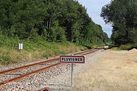
Former Bf. Pluvigner

Former Lambel - Camors

Baud train station
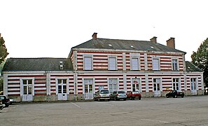
Pontivy train station


literature
- B., Inauguration de la ligne d'Auray à Napoléonville chemin de fer d'Orléans, dimanche 18 December 1864 , compte rendu extrait du "Journal de Vannes" du 24 December 1864, Vannes, Impr. De De Lamarzelle, 1865, 16 p . scan
- Jean-Pierre Nennig: Le chemin de fer de Bretagne Sud: Auray - Pontivy. Guérande, JPN Editions, 2008, 224 p. ( ISBN 2-9519898-5-7 ), pp. 177-184
- Jean-Pierre Rigouard: Gares et tortillards de Bretagne: 55 km d'Auray à Pontivy. Cheminements, 2007, 299 p. ( ISBN 978-2-84478-609-8 ), pp. 47-50
- Trafic à l'usine de nutrition animale “La gare de Baud”. Loco Revue, no 653, December 2001
Web links
PARB'ER - Initiative for the preservation and regeneration of the route (French)
Individual evidence
- ↑ a b c J. B. Duvergier, “Décret impérial qui approuve la convention passée, le 14 June 155, pour la concession du chemin de fer de Nantes à Châteaulin, avec embranchement sur Napoléonville” Collection complète des lois, décrets, ordonnances, règlements, et avis du Conseil d'État, sur gallica.bnf.fr, L. Larose, 1855 (consulté le 3 juin 2014), pp. 222–223.
- ↑ a b c Nennig 2008, p. 178
- ^ Rail Bretagne cached by Wikiwix
- ↑ a b Jean-Pierre Nennig 2008, p. 177
- ↑ Conseil général du Morbihan, “Chemins de fer” , Rapports du Préfet et délibérations du Conseil général, sur gallica.bnf.fr, 1858 (consulté le 3 juin 2014), p. 41
- ↑ Conseil général du Morbihan, “Chemins de fer” , Rapports du Préfet et délibérations du Conseil général, sur gallica.bnf.fr, 1859 (consulté le 3 juin 2014), p. 43.
- ↑ Conseil général du Morbihan, “Chemin de fer de Nantes à Chateaulin” , Rapports du Préfet et délibérations du Conseil général, sur gallica.bnf.fr, 1860 (consulté le 3 June 2014), p. 36.
- ↑ Conseil général du Morbihan, “Chemin de fer de Nantes à Chateaulin” , Rapports du Préfet et délibérations du Conseil général, sur gallica.bnf.fr, 1861 (consulté le 3 June 2014), p. 50.
- ↑ Conseil général du Morbihan, “Chemins de fer” , Rapports du Préfet et délibérations du Conseil général, sur gallica.bnf.fr, 1862 (consulté le 3 juin 2014), p. 69.
- ↑ Conseil général du Morbihan, "Chemin de fer" , Reports du Préfet et délibérations du Conseil général, sur gallica.bnf.fr, 1863 (consulté le 3 juin 2014), pp. 131-132.
- ↑ Conseil général du Morbihan, “Chemins de fer” , Rapports du Préfet et délibérations du Conseil général, sur gallica.bnf.fr, 1864 (consulté le 3 juin 2014), p. 63
- ↑ letelegramme.fr: Pluvigner patrimoines. A la découverte de l'ancienne gare
- ↑ a b Annales des ponts et chaussées: Mémoires et documents relatifs à l'art des constructions et au service de l'ingénieur; lois, décrets, et autres actes concernant l'administration des ponts et chaussées, 4e série, volume 16, 2e semestre 1868, Paris, 1868 pp. ( On Google Books ).
- ↑ Name at SNCF, the ridge underpassed is called Bot-Chosse or Botchosse , sometimes the name Tunnel von Baud is also used
- ^ The associated village is now called Castennec
- ↑ www.train-blavet-ocean.bzh