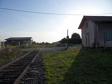
Gray – Saint-Jean-de-Losne railway line
| Gray-Saint-Jean-de-Losne | |||||||||||||||||||||||||||||||||||||||||||||||||||||||||||||||||||||||||||||||||||||||||||||||||||||||||||||||||||||||||||||
|---|---|---|---|---|---|---|---|---|---|---|---|---|---|---|---|---|---|---|---|---|---|---|---|---|---|---|---|---|---|---|---|---|---|---|---|---|---|---|---|---|---|---|---|---|---|---|---|---|---|---|---|---|---|---|---|---|---|---|---|---|---|---|---|---|---|---|---|---|---|---|---|---|---|---|---|---|---|---|---|---|---|---|---|---|---|---|---|---|---|---|---|---|---|---|---|---|---|---|---|---|---|---|---|---|---|---|---|---|---|---|---|---|---|---|---|---|---|---|---|---|---|---|---|---|---|
|
At the Champdôtre-Pont train station. Line of sight Trouhans
| |||||||||||||||||||||||||||||||||||||||||||||||||||||||||||||||||||||||||||||||||||||||||||||||||||||||||||||||||||||||||||||
| Route number (SNCF) : | 851 000 | ||||||||||||||||||||||||||||||||||||||||||||||||||||||||||||||||||||||||||||||||||||||||||||||||||||||||||||||||||||||||||||
| Route length: | 54.6 km | ||||||||||||||||||||||||||||||||||||||||||||||||||||||||||||||||||||||||||||||||||||||||||||||||||||||||||||||||||||||||||||
| Gauge : | 1435 mm ( standard gauge ) | ||||||||||||||||||||||||||||||||||||||||||||||||||||||||||||||||||||||||||||||||||||||||||||||||||||||||||||||||||||||||||||
| Maximum slope : | 10 ‰ | ||||||||||||||||||||||||||||||||||||||||||||||||||||||||||||||||||||||||||||||||||||||||||||||||||||||||||||||||||||||||||||
| Dual track : | formerly partly yes | ||||||||||||||||||||||||||||||||||||||||||||||||||||||||||||||||||||||||||||||||||||||||||||||||||||||||||||||||||||||||||||
|
|||||||||||||||||||||||||||||||||||||||||||||||||||||||||||||||||||||||||||||||||||||||||||||||||||||||||||||||||||||||||||||
The Gray – Saint-Jean-de-Losne railway is a 55 km long, single-track , standard-gauge railway line in France . It connected the former Gray railway junction in the Haute-Saône department in a north-east-south-west direction with the Paris – Mulhouse mainline and south-east past Dijon to Saint-Jean-de-Losne on the Dijon – Saint-Amour line . This last section is no longer used today. The rest is part of the holdings of the state-owned company SNCF Réseau .
history
This route included in the concession award a southwestern extension to Chalon-sur-Saône (today parts of the partly former routes 867, 865 and 860) via Verdun-sur-le-Doubs , Saint-Bonnet-en-Bresse and Seurre , the total was about twice as long. But different companies were interested in the acquisition of the concession, the construction and later the operation, so that the project was divided. After the opening, however, trains ran along the entire route.
Northern section
Together with the Dijon – Mulhouse section via Besançon , the concession for the construction of the connection from Villers-les-Pots to Gray was granted in 1846 . This was taken over by a consortium based in Besançon, which in turn passed on February 12, 1856 to the Compagnie du chemin de fer de Paris à Lyon , which also took over the construction. A year later this company went bankrupt and was taken over by the Compagnie des chemins de fer de Paris à Lyon et à la Méditerranée . The line was already completed on June 10, 1855 and officially opened on November 10, 1856.
On July 1, 1938, passenger traffic was stopped. In stages from the early 1950s to the early 1970s, further sections were closed, of which only the five kilometer long section between Gray and Mantoche was spared.
Southern section
The southern section from Villers-les-Pots to Saint-Jean-de-Losne was not tackled until the 1880s. The tender was opened in the summer of 1880 and the concession was granted on November 20, 1883 to the Compagnie des chemins de fer de Paris à Lyon et à la Méditerranée . It became a feeder route for the Strategic Railways towards the French-German border . The intersection for the Paris – Mulhouse connection was laid out on two tracks because of its strategic importance and, with overpass structures , was identical to the plan . A loading station for military purposes with two loading ramps was built near the Gleisdreieck at Villers-les-Pots.
The opening for passenger traffic took place on July 12, 1887; it was closed on July 1, 1938 at the same time as the northern section.
topography
The topography has few abnormalities, so that hardly any artificial structures had to be created for the construction . Only a few short streams had to be bridged. Just in the Haute-Saone is part of the tunnel Mantoche , one of only eight tunnels in the department. This tunnel, located at 200 meters above sea level, to the west of the eponymous town, crosses under the Bouloye des Bois de Mantoche , which is lined with wine .
Individual evidence
- ^ Bulletin des lois de la République française . Loi relative au Chemin de fer de Dijon à Mulhouse, avec embranchements d'Auxonne sur Gray, et de Dole sur Salins. Imprimerie nationale de Lois, Paris 1846
- ^ Bulletin of the Lois de la République Française . Décret qui autorise la concession directe du Chemin de Fer de Dijon à Besançon, avec embranchement sur Gray. Imprimerie nationale de Lois, Paris 1852
- ^ Bulletin of the Lois de la République Française . Loi qui déclare d'utilité publique l'établissement d'un Chemin de fer de Chagny à Auxonne, avec embranchement de Saint-Loup-de-la-Salle à Beaune. Imprimerie nationale, Paris 1880
- ^ List des quais . Réseau ferré de France. Document de référence du réseau ferré national. Horaires de service 2010 et 2011, page 86.
Web links
- Ligne de Gray à Saint-Jean-de-Losne on lignes-oubliees.com, December 23, 2017 (French)
- Tunnel de Mantoche on Inventaire des Tunnels ferroviaires de France.
