Seurre
| Seurre | ||
|---|---|---|

|
|
|
| region | Bourgogne-Franche-Comté | |
| Department | Côte-d'Or | |
| Arrondissement | Beaune | |
| Canton | Brazey-en-Plaine | |
| Community association | Rives de Saône | |
| Coordinates | 47 ° 0 ′ N , 5 ° 9 ′ E | |
| height | 176-192 m | |
| surface | 8.99 km 2 | |
| Residents | 2,353 (January 1, 2017) | |
| Population density | 262 inhabitants / km 2 | |
| Post Code | 21250 | |
| INSEE code | 21607 | |
| Website | http://www.seurre.fr/ | |
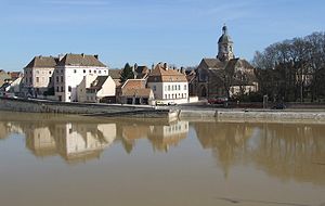
 On the banks of the Saône |
||
Seurre is a French town with 2,353 inhabitants (at January 1, 2017) in the department of Côte-d'Or in the region Bourgogne Franche-Comté and was until 2015 the main town ( chef-lieu ) of the eponymous canton Seurre in Arrondissement of Beaune .
In an idyllic location on the Saône , it has a small marina. Despite a turbulent history, in the course of which parts of the city were destroyed, there are still several buildings worth seeing in the old town, including an old hospice ( Hôtel-Dieu ). Another of these older houses houses a local history museum and tourist office . The church of St. Martin is remarkable both for its architecture and for its Julien Tribuot organ from 1699 and its carillon with 47 bells.
On the outskirts of the city is the open-air museum L'étang rouge , which shows old village houses from the Saône Valley that have been rebuilt there.
Tourism is an important industry in Seurre, there are two hotels, two chambres d'hôte pensions and three campsites. Well-developed country roads lead from Seurre to other places worth seeing, such as Chalon-sur-Saône and Citeaux .
Population development
| year | 1962 | 1968 | 1975 | 1982 | 1990 | 1999 | 2007 | 2016 |
| Residents | 2396 | 2683 | 2822 | 2694 | 2728 | 2666 | 2473 | 2381 |
| Sources: Cassini and INSEE | ||||||||

