
Magny-les-Villers
| Magny-les-Villers | ||
|---|---|---|

|
|
|
| region | Bourgogne-Franche-Comté | |
| Department | Côte-d'Or | |
| Arrondissement | Beaune | |
| Canton | Nuits-Saint-Georges | |
| Community association | Gevrey-Chambertin et de Nuits-Saint-Georges | |
| Coordinates | 47 ° 6 ' N , 4 ° 53' E | |
| height | 253-423 m | |
| surface | 3.83 km 2 | |
| Residents | 243 (January 1, 2017) | |
| Population density | 63 inhabitants / km 2 | |
| Post Code | 21700 | |
| INSEE code | 21368 | |
| Website | https://magnylesvillersmairie.jimdo.com/ | |

Magny-les-Villers is a French municipality with 243 inhabitants (as of January 1 2017) in the Côte-d'Or department in the region of Bourgogne Franche-Comté (before 2016 Bourgogne ); it belongs to the Arrondissement of Beaune and the canton of Nuits-Saint-Georges .
geography
Magny-lès-Villers is about 26 kilometers south-southwest of Dijon . Magny-lès-Villers is surrounded by the neighboring communities of Villers-la-Faye in the north, Corgoloin in the east, Ladoix-Serrigny in the south and south-east, Pernand-Vergelesses in the south and south-west and Échevronne in the west and north-west.
population
| year | 1962 | 1968 | 1975 | 1982 | 1990 | 1999 | 2006 | 2011 | 2016 |
|---|---|---|---|---|---|---|---|---|---|
| Residents | 205 | 207 | 184 | 224 | 242 | 246 | 258 | 256 | 246 |
Attractions
- church
- Notre-Dame-de-Bonheur chapel
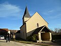
church

Notre-Dame-de-Bonheur chapel


Web links
Commons : Magny-lès-Villers - Collection of images, videos and audio files
Individual evidence
- ^ Magny-lès-Villers on the Insee website.