
Saint-Romain (Côte-d'Or)
| Saint-Romain | ||
|---|---|---|
.svg)
|
|
|
| region | Bourgogne-Franche-Comté | |
| Department | Côte-d'Or | |
| Arrondissement | Beaune | |
| Canton | Ladoix-Serrigny | |
| Community association | Beaune Cote et Sud | |
| Coordinates | 47 ° 0 ' N , 4 ° 43' E | |
| height | 274-564 m | |
| surface | 19.65 km 2 | |
| Residents | 220 (January 1, 2017) | |
| Population density | 11 inhabitants / km 2 | |
| Post Code | 21190 | |
| INSEE code | 21569 | |
| Website | http://www.mairie-saint-romain.fr/ | |

|
||

Saint-Romain is a French commune of 220 inhabitants (as of January 1, 2017) in the department of Côte-d'Or in the region Bourgogne Franche-Comté ; it belongs to the Arrondissement Beaune and is part of the canton Ladoix-Serrigny (until 2015: canton Nolay ).
geography
Saint-Romain is located about 26 kilometers north-northwest of Chalon-sur-Saône and about 44 kilometers south-southwest of Dijon . Saint-Romain is surrounded by the neighboring communities of Montceau-et-Écharnant in the north and north-west, Meloisey in the north, Volnay in the east and north-east, Auxey-Duresses in the south and east, Baubigny in the west and south-west, Val-Mont with Ivry-en- Montagne in the west and north-west and Cussy-la-Colonne in the north-west.
Population development
| year | 1962 | 1968 | 1975 | 1982 | 1990 | 1999 | 2006 | 2013 |
| Residents | 293 | 323 | 265 | 250 | 241 | 227 | 243 | 223 |
| Source: Cassini and INSEE | ||||||||
Attractions
- Church Saint-Romain from the 15th century
- Remains of the castle
- Saint-Romain Castle
- Old Mill
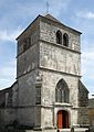
church
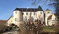
Saint-Romain Castle

Old Mill
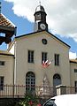
town hall


