
Gilly-lès-Citeaux
| Gilly-lès-Citeaux | ||
|---|---|---|
.svg)
|
|
|
| region | Bourgogne-Franche-Comté | |
| Department | Côte-d'Or | |
| Arrondissement | Beaune | |
| Canton | Nuits-Saint-Georges | |
| Community association | Gevrey-Chambertin et de Nuits-Saint-Georges | |
| Coordinates | 47 ° 10 ′ N , 4 ° 59 ′ E | |
| height | 206-254 m | |
| surface | 11.03 km 2 | |
| Residents | 705 (January 1, 2017) | |
| Population density | 64 inhabitants / km 2 | |
| Post Code | 21640 | |
| INSEE code | 21297 | |

Gilly-les-Citeaux is a French municipality with 705 inhabitants (as of January 1 2017) in the Côte-d'Or department in the region of Bourgogne Franche-Comté (before 2016 Bourgogne ); it belongs to the Arrondissement of Beaune and the canton of Nuits-Saint-Georges .
geography
Gilly-lès-Cîteaux is located about 20 kilometers south-southwest of Dijon . Gilly-lès-Cîteaux is surrounded by the neighboring municipalities of Morey-Saint-Denis in the north and north-west, Saint-Philibert in the north-east, Broindon in the north-east, Épernay-sous-Gevrey in the east, Saint-Bernard in the south-east, Flagey-Echézeaux in the south, Vougeot in the west and south-west and Chambolle-Musigny in the west.
population
| year | 1962 | 1968 | 1975 | 1982 | 1990 | 1999 | 2006 | 2011 | 2016 |
|---|---|---|---|---|---|---|---|---|---|
| Residents | 397 | 403 | 415 | 461 | 517 | 567 | 595 | 640 | 691 |
Attractions
- Saint Germain Church
- Gilly-lès-Cîteaux castle from the 17th century, former priory, monument historique since 1978
- Saulx tithe barn from the 13th century
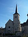
Saint Germain Church

Gilly-lès-Cîteaux castle


Personalities
- Michel Sarrazin (1659–1734), naturalist, botanist and doctor
Web links
Commons : Gilly-lès-Cîteaux - Collection of images, videos and audio files
Individual evidence
- ↑ Gilly-lès-Cîteaux on the Insee website.