Labergement-lès-Seurre
| Labergement-lès-Seurre | ||
|---|---|---|
|
|
||
| region | Bourgogne-Franche-Comté | |
| Department | Côte-d'Or | |
| Arrondissement | Beaune | |
| Canton | Brazey-en-Plaine | |
| Community association | Rives de Saône | |
| Coordinates | 47 ° 0 ' N , 5 ° 6' E | |
| height | 174-211 m | |
| surface | 28.83 km 2 | |
| Residents | 995 (January 1, 2017) | |
| Population density | 35 inhabitants / km 2 | |
| Post Code | 21820 | |
| INSEE code | 21332 | |
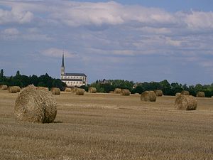
 View of town with Église de l'Assomption |
||
Labergement-lès-Seurre is a commune with 995 inhabitants (at January 1, 2017) in the department of Côte-d'Or in the region Bourgogne Franche-Comté . It belongs to the Arrondissement of Beaune and the Canton of Brazey-en-Plaine .
geography
The municipality is located around 20 kilometers east of Beaune and has a short border section with the neighboring Saône-et-Loire department . Neighboring communities are Bagnot in the north, Pouilly-sur-Saône in the east, Jallanges and Trugny in the south-east, Chivres in the south, Palleau in the south-west (Dép. Saône-et-Loire), Corberon and Corgengoux in the west and Montmain in the north-west.
The Saône River runs along the southeastern municipal boundary, and a few smaller streams (e.g. Genotte and Ruisseau de la Deuxième Raie ) drain the municipality into the Saône. In the west and north there are larger forest areas, where there are also several lakes, especially in the north. The municipality's capital is on the D 115H, the center is to the east of the Rue de l'Église .
Population development
| year | 1968 | 1975 | 1982 | 1990 | 1999 | 2006 | 2016 |
| Residents | 718 | 663 | 723 | 785 | 795 | 896 | 999 |
