
Meursanges
| Meursanges | ||
|---|---|---|
|
||
| region | Bourgogne-Franche-Comté | |
| Department | Côte-d'Or | |
| Arrondissement | Beaune | |
| Canton | Ladoix-Serrigny | |
| Community association | Beaune Cote et Sud | |
| Coordinates | 47 ° 0 ′ N , 4 ° 57 ′ E | |
| height | 178-204 m | |
| surface | 14.26 km 2 | |
| Residents | 557 (January 1, 2017) | |
| Population density | 39 inhabitants / km 2 | |
| Post Code | 21200 | |
| INSEE code | 21411 | |

Meursanges is a French municipality with 557 inhabitants (as of January 1 2017) in the Côte-d'Or department in the region of Bourgogne Franche-Comté (before 2016 Bourgogne ); it belongs to the Arrondissement of Beaune and the canton of Ladoix-Serrigny .
geography
Meursanges is located about 39 kilometers south-southwest of Dijon . Meursanges is surrounded by the neighboring communities of Marigny-lès-Reullée in the north, Corgengoux in the east, Chevigny-en-Valière in the southeast, Saint-Loup-Géanges in the south, Sainte-Marie-la-Blanche in the southwest, Combertault in the west and Ruffey- lès-Beaune in the northwest.
population
| year | 1962 | 1968 | 1975 | 1982 | 1990 | 1999 | 2006 | 2011 | 2016 |
|---|---|---|---|---|---|---|---|---|---|
| Residents | 288 | 262 | 242 | 285 | 312 | 364 | 445 | 495 | 552 |
Attractions
- Saint-Pierre church
- La Borde Castle, only remains, reconstructed in the 17th century

Saint-Pierre church
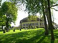
La Borde Castle


Web links
Commons : Meursanges - collection of images, videos and audio files
Individual evidence
- ↑ Meursanges on the site of the Insee.