
Valforêt
| Valforêt | ||
|---|---|---|
|
||
| region | Bourgogne-Franche-Comté | |
| Department | Côte-d'Or | |
| Arrondissement | Beaune | |
| Canton | Longvic | |
| Community association | Communauté de communes de Gevrey-Chambertin et de Nuits-Saint-Georges | |
| Coordinates | 47 ° 15 ' N , 4 ° 53' E | |
| height | 330-579 m | |
| surface | 22.04 km 2 | |
| Residents | 320 (January 1, 2017) | |
| Population density | 15 inhabitants / km 2 | |
| Post Code | 21220 | |
| INSEE code | 21178 | |

Valforêt is a French commune of 320 inhabitants (at January 1, 2017) in the department of Côte-d'Or in the region Bourgogne Franche-Comté . It belongs to the canton of Longvic and the Arrondissement of Beaune .
It was created with effect from January 1, 2019 as Commune nouvelle by amalgamating the former municipalities of Clémencey and Quemigny-Poisot, which have the status of a Commune déléguée in the new municipality . The administrative headquarters are located in Clémencey.
structure
| District | former INSEE code |
Area (km²) | Population as of January 1, 2017 |
|---|---|---|---|
| Clémencey (administrative headquarters) | 21178 | 10.72 | 121 |
| Quemigny-Poisot | 21513 | 11.32 | 199 |
location
Neighboring municipalities are Fleurey-sur-Ouche in the northwest, Urcy in the north, Flavignerot in the northeast, Couchey , Fixin and Brochon in the east, Chambœuf in the southeast, Semezanges in the south and Gergueil in the west.
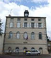
The house of Mairie of Clemencey

Church construction in Quemigny-Poisot


Web links
Individual evidence
- ↑ Decree of the Prefecture No. 21-2018-11-21-002 on the formation of the Commune nouvelle Valforêt of November 21, 2018.
- ↑ current population according to INSEE