
L'Étang-Vergy
| L'Étang-Vergy | ||
|---|---|---|
.svg)
|
|
|
| region | Bourgogne-Franche-Comté | |
| Department | Côte-d'Or | |
| Arrondissement | Beaune | |
| Canton | Longvic | |
| Community association | Gevrey-Chambertin et de Nuits-Saint-Georges | |
| Coordinates | 47 ° 11 ' N , 4 ° 53' E | |
| height | 302-500 m | |
| surface | 2.65 km 2 | |
| Residents | 213 (January 1, 2017) | |
| Population density | 80 inhabitants / km 2 | |
| Post Code | 21220 | |
| INSEE code | 21254 | |
| Website | http://www.l-etang-vergy.com/ | |

L'Etang-Vergy is a French municipality with 213 inhabitants (at January 1, 2017) in the Côte-d'Or department in the region of Bourgogne Franche-Comté (before 2016 Bourgogne ); it belongs to the Arrondissement of Beaune and the canton of Longvic (until 2015 Gevrey-Chambertin ).
geography
L'Étang-Vergy is located about 22 kilometers south-southwest of Dijon . L'Étang-Vergy is surrounded by the neighboring communities of Ternant in the north and north-west, Reulle-Vergy in the east and north-east, Curtil-Vergy in the south-east, Messanges in the south and Bévy in the west and south-west.
population
| year | 1962 | 1968 | 1975 | 1982 | 1990 | 1999 | 2006 | 2013 |
|---|---|---|---|---|---|---|---|---|
| Residents | 180 | 176 | 160 | 163 | 150 | 183 | 201 | 198 |
Attractions
- Saint-Charles-Borromée church
- lock
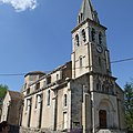
Saint-Charles-Borromée church

lock


Web links
Commons : L'Étang-Vergy - collection of images, videos and audio files
Individual evidence
- ↑ L'Étang-Vergy on the Insee website.