
Villers-les-Pots
| Villers-les-Pots | ||
|---|---|---|
.svg)
|
|
|
| region | Bourgogne-Franche-Comté | |
| Department | Côte-d'Or | |
| Arrondissement | Dijon | |
| Canton | Auxonne | |
| Community association | Auxonne Pontailler Val de Saône | |
| Coordinates | 47 ° 13 ' N , 5 ° 21' E | |
| height | 182-205 m | |
| surface | 10.43 km 2 | |
| Residents | 1,134 (January 1, 2017) | |
| Population density | 109 inhabitants / km 2 | |
| Post Code | 21130 | |
| INSEE code | 21699 | |
| Website | http://www.villerslespots.fr/ | |
 Town hall (Mairie) of Villers-les-Pots |
||

Villers-les-Pots is a French commune with 1,134 inhabitants (as of January 1 2017) in the department of Côte-d'Or in the region Bourgogne Franche-Comté . It belongs to the Arrondissement of Dijon and the Canton of Auxonne . The inhabitants are called potiers .
geography
Villers-les-Pots is located about 32 kilometers east-southeast of Dijon . Villers-les-Pots is surrounded by the neighboring communities of Athée in the north and east, Auxonne in the east and south-east, Tillenay in the south, Champdôtre in the south and south-west, Tréclun in the south-west, Soirans in the west and Collonges-lès-Premières in the west.
Population development
| 1962 | 1968 | 1975 | 1982 | 1990 | 1999 | 2006 | 2013 | |
|---|---|---|---|---|---|---|---|---|
| 722 | 731 | 790 | 763 | 855 | 871 | 999 | 1,076 | |
| Source: Cassini and INSEE | ||||||||
Attractions
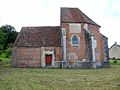
- Saint-Michel church from the 17th century
- Notre-Dame-de-la-Levée chapel from the 16th century

Saint-Michel church
Notre-Dame-de-la-Levée chapel

.JPG)
Personalities
- Léon Gastinel (1823–1906), composer and violinist
Web links
Commons : Villers-les-Pots - Collection of images, videos and audio files