
Moloy
| Moloy | ||
|---|---|---|
|
||
| region | Bourgogne-Franche-Comté | |
| Department | Côte-d'Or | |
| Arrondissement | Dijon | |
| Canton | Is-sur-Tille | |
| Community association | Vallées de la Tille et de l'Ignon | |
| Coordinates | 47 ° 32 ' N , 4 ° 57' E | |
| height | 315-519 m | |
| surface | 19.23 km 2 | |
| Residents | 233 (January 1, 2017) | |
| Population density | 12 inhabitants / km 2 | |
| Post Code | 21120 | |
| INSEE code | 21421 | |
 Moloy Town Hall (Mairie) |
||

Moloy is a French municipality with 233 inhabitants (as of January 1 2017) in the department of Côte-d'Or in the region Bourgogne Franche-Comté . It belongs to the Arrondissement of Dijon and the canton of Is-sur-Tille .
geography
Moloy is located about 28 kilometers north-northeast of Dijon am Ignon . The municipality is surrounded by Salives in the north, Courtivron in the east and Frénois in the south and west.
Population development
| 1962 | 1968 | 1975 | 1982 | 1990 | 1999 | 2006 | 2013 |
| 217 | 215 | 214 | 207 | 210 | 219 | 223 | 217 |
| Source: Cassini and INSEE | |||||||
Attractions
- Saint-Loup church from the 13th century, renovations from the 15th century
- Castle from the 16th century with additions and alterations from the 18th century
- Two wash houses

Saint-Jean-Baptiste church

one of the towers of the former fortification

Well and former washing area
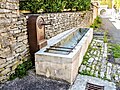
Well and former cattle trough


Web links
Commons : Moloy - collection of images, videos and audio files