Darois
| Darois | ||
|---|---|---|

|
|
|
| region | Bourgogne-Franche-Comté | |
| Department | Côte-d'Or | |
| Arrondissement | Dijon | |
| Canton | Fontaine-lès-Dijon | |
| Community association | Forêts, Seine and Suzon | |
| Coordinates | 47 ° 23 ' N , 4 ° 56' E | |
| height | 340-546 m | |
| surface | 8.12 km 2 | |
| Residents | 493 (January 1, 2017) | |
| Population density | 61 inhabitants / km 2 | |
| Post Code | 21121 | |
| INSEE code | 21227 | |
Darois is a commune in the Côte-d'Or department in the region of Bourgogne Franche-Comté . It belongs to the Arrondissement of Dijon and to the municipal association Forêts, Seine et Suzon, founded in 2014 .
geography
The municipality of Darois with 493 inhabitants (January 1, 2017) is located twelve kilometers northwest of the city of Dijon in a hilly area south of the Langres plateau at around 500 m above sea level. The 8.12 km² large municipal area of Darois extends in the north-west into the valley of the Suzon , a tributary of the Ouche . Here and in the southeast of the municipality Darois has shares in the forest area Forêt Domaniale de Val-Suzon . The highest point is a flat ridge in the north called Butte de Corniot with 546 m above sea level. Neighboring communities of Darois are Étaules in the north, Hauteville-lès-Dijon in the south-east, Daix in the south, Prenois in the west and Val-Suzon in the north-west.
history
The first traces of human settlement in and around Darois can be dated back to the Neolithic Age . The remains of a camp have been found on a rocky promontory called Châtelet Etaules - today on the edge of a rock formation on the wooded spur of La Motte . An early church in Darois is already occupied for the year 438. In the 11th and 12th centuries - at the time of Pope Innocent II - this church already had a branch in neighboring Étaules . The name of the village developed as follows:
- • 802 Darilla
- • 1245 Daurois
- • 1387 Darroy
- • 1423 Derrois
- • 1646 Darroye
- • 1793 Darois
There are two theories about the origin of the name of the village: one is that it was derived from the name of a warrior; the second hypothesis indicates the origin of the Gallic derwo for oak . From 1429 Darois belonged to the Dijon Bailiwick. In 1677 a new church was built in place of the old dilapidated one. For a long time, the abbots of Saint-Etienne and Saint-Seine fought for sovereignty over ecclesiastical taxes. Finally, the apostolic authority of the Abbot of Cîteaux decided that there should be an annually rotating membership. Darois was on the historically important road and post connection from Lyon via Dijon to the Seine source and further down the Seine via Troyes to Paris and was a horse-changing station for a long time. But Darois never got beyond the status of a small farming village (at the end of the 18th century there were about fifty inhabitants). It was not until the second half of the 20th century that the population began to grow significantly, which can be attributed to inexpensive living space in the countryside for the city dwellers from nearby Dijon.
Population development
| year | 1962 | 1968 | 1975 | 1982 | 1990 | 1999 | 2009 | 2017 | |
| Residents | 488 | 418 | 163 | 272 | 313 | 352 | 448 | 493 | |
| Sources: Cassini and INSEE | |||||||||
Attractions
- Saint Martin Church
Economy and Infrastructure
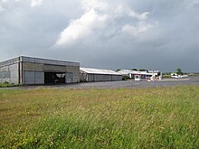
Agriculture has traditionally been an important occupation in Darois. The agricultural products from Darois include cheese ( Emmental français est-central ), poultry, pork and beef as well as mustard ( Moutarde de Bourgogne ). The aircraft yards Finch Aircraft (construction of the popular single-engine low- wing aircraft Robin DR 400 in wood construction) and Dyn'Aéro (including production of the DynAero MCR01 ) also offer many jobs . The companies use the Dijon-Darois airfield, southeast of Darois, to test the aircraft. The airfield has also been used by the Aéroclub de la Côte-d'Or air sports club since 1957 . He also operates a flight school for motorized pilots, microlight pilots and helicopter pilots.
The trunk road D 971 (formerly RN 71 ) runs through Darois from Dijon via Châtillon-sur-Seine to Troyes . Other road connections lead from Darois to Prenois and Étaules . The next motorway junction is in Plombières-lès-Dijon, twelve kilometers away, on the A38 autoroute over the 1040 m high Col de Pennes in a south-westerly direction. There are train connections in all directions in the nearby Dijon transport hub.
supporting documents
- ↑ http://www.darois.fr/histoire Name development and history abstract on monsaintegreve.expertpublic.fr/ (French)
- ↑ Darois on cassini.ehess.fr
- ↑ Darois on insee.fr


