
Lantenay (Côte-d'Or)
| Lantenay | ||
|---|---|---|
.svg)
|
|
|
| region | Bourgogne-Franche-Comté | |
| Department | Côte-d'Or | |
| Arrondissement | Dijon | |
| Canton | Talent | |
| Community association | Ouche et Montagne | |
| Coordinates | 47 ° 21 ′ N , 4 ° 52 ′ E | |
| height | 295-581 m | |
| surface | 17.13 km 2 | |
| Residents | 510 (January 1, 2017) | |
| Population density | 30 inhabitants / km 2 | |
| Post Code | 21370 | |
| INSEE code | 21339 | |
 Town hall (Mairie) of Lantenay |
||

Lantenay is a French municipality with 510 inhabitants (as of January 1 2017) in the department of Côte-d'Or in the region Bourgogne Franche-Comté . The municipality belongs to the Arrondissement of Dijon and the canton of Talant (until 2015: canton of Dijon-5 ).
geography
Lantenay is about 13 kilometers west of Dijon and belongs to the Bourgogne wine region . Lantenay is surrounded by the neighboring communities of Pasques in the north, Prenois in the northeast, Plombières-lès-Dijon in the east, Velars-sur-Ouches in the east and southeast, Fleurey-sur-Ouche in the south and Ancey in the west. The Lantenay stop is on the Paris – Marseille railway line .
Population development
| 1962 | 1968 | 1975 | 1982 | 1990 | 1999 | 2006 | 2013 |
|---|---|---|---|---|---|---|---|
| 325 | 288 | 266 | 302 | 315 | 425 | 454 | 504 |
| Source: Cassini and INSEE | |||||||
Attractions
- Saint Martin Church
- Saint-Louis Chapel
- Lantenay Castle

Saint Martin Church

Saint-Louis Chapel
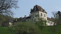
Lantenay Castle


Web links
Commons : Lantenay (Côte-d'Or) - Collection of images, videos and audio files