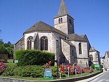
Selongey
| Selongey | ||
|---|---|---|

|
|
|
| region | Bourgogne-Franche-Comté | |
| Department | Côte-d'Or | |
| Arrondissement | Dijon | |
| Canton | Is-sur-Tille | |
| Community association | Tille et Venelle | |
| Coordinates | 47 ° 35 ' N , 5 ° 11' E | |
| height | 278-464 m | |
| surface | 46.42 km 2 | |
| Residents | 2,403 (January 1, 2017) | |
| Population density | 52 inhabitants / km 2 | |
| Post Code | 21260 | |
| INSEE code | 21599 | |
| Website | http://www.selongey.com/ | |
Selongey is a French commune with 2,403 inhabitants (as of January 1 2017) in the department of Côte-d'Or in the region Bourgogne Franche-Comté . It belongs to the Arrondissement of Dijon and the canton of Is-sur-Tille (until 2015: canton of Selongey ). The inhabitants are called Selongéen .
geography
Selongey is located around 30 kilometers northeast of Dijon on the Venelle River . Selongey is surrounded by the neighboring communities Vernois-lès-Vesvres in the north and north-west, Esnoms-au-Val in the north and north-east, Boussenois , Rivière-lès-Fosses and Vaux-sous-Aubigny in the north-east, Occey in the east, Chazeuil , Véronnes and Orville in the south-east, Til-Châtel in the south, Échevannes , Crécey-sur-Tille and Villey-sur-Tille in the south-west, Marey-sur-Tille in the west and Foncegrive in the north-west. The A31 autoroute and the former Route nationale 74 (today's D974) run through the municipality .
population
| year | 1962 | 1968 | 1975 | 1982 | 1990 | 1999 | 2006 | 2012 |
|---|---|---|---|---|---|---|---|---|
| Residents | 1,732 | 2,102 | 2,363 | 2,519 | 2,386 | 2.233 | 2,267 | 2,426 |
Attractions
- Sainte-Gertrude church, monument historique since 1908
- Chapel of Sainte-Gertrude, monument historique since 1970
- Gallo-Roman ruins of Les Tuillières, Monument historique since 1989
Parish partnership
There is a community partnership with the German community of Gundersheim in Rhineland-Palatinate .

