Salives
| Salives | ||
|---|---|---|
|
|
||
| region | Bourgogne-Franche-Comté | |
| Department | Côte-d'Or | |
| Arrondissement | Dijon | |
| Canton | Is-sur-Tille | |
| Community association | Tille et Venelle | |
| Coordinates | 47 ° 37 ' N , 4 ° 55' E | |
| height | 343-527 m | |
| surface | 47.85 km 2 | |
| Residents | 206 (January 1, 2017) | |
| Population density | 4 inhabitants / km 2 | |
| Post Code | 21580 | |
| INSEE code | 21579 | |
| Website | http://salives.com/ | |
Salives is a French municipality with 206 inhabitants (at January 1, 2017) in the Côte-d'Or department in the region of Bourgogne Franche-Comté (before 2016 Bourgogne ). It belongs to the Arrondissement of Dijon and the canton of Is-sur-Tille (until 2015 Grancey-le-Château-Neuvelle ). Inhabitants of the municipality are called Salivois .
geography
Salives is about 40 kilometers north of Dijon on the Langres plateau . Salives is surrounded by the municipalities of Minot in the north, Fraignot-et-Vesvrotte in the northeast, Barjon and Le Meix in the east, Poiseul-lès-Saulx and Courtivron in the southeast, Moloy and Frénois in the south, Léry in the southwest and Échalot in the west.
The Valduc military nuclear research facility is located in the southwest of the municipality .
Population development
| 1962 | 1968 | 1975 | 1982 | 1990 | 1999 | 2006 | 2013 | |
|---|---|---|---|---|---|---|---|---|
| 329 | 346 | 286 | 229 | 180 | 232 | 259 | 228 | |
| Source: INSEE | ||||||||
Attractions
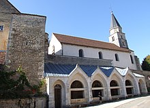
- Saint-Martin church from the 11th century
- Remains of the donjon from the 11th century
- Remains of the fortifications
- Building of the Knights Templar

Personalities
- Jeanne Arnould-Plessy (1819–1897), actress, buried here
