
Échalot
| Échalot | ||
|---|---|---|
.svg)
|
|
|
| region | Bourgogne-Franche-Comté | |
| Department | Côte-d'Or | |
| Arrondissement | Montbard | |
| Canton | Châtillon-sur-Seine | |
| Community association | Pays Châtillonnais | |
| Coordinates | 47 ° 37 ′ N , 4 ° 50 ′ E | |
| height | 370-526 m | |
| surface | 27.65 km 2 | |
| Residents | 95 (January 1, 2017) | |
| Population density | 3 inhabitants / km 2 | |
| Post Code | 21510 | |
| INSEE code | 21237 | |

Échalot is a French municipality with 95 inhabitants (as at 1st January 2017) in the Côte-d'Or department in the region of Bourgogne Franche-Comté (before 2016 Burgundy ). It belongs to the arrondissement of Montbard and the commune association Pays Châtillonnais, founded in 2003 . The residents call themselves Échalotais .
geography
Échalot is located on the southwestern edge of the Langres plateau , about 42 kilometers northwest of Dijon at the source of the Brévon , a 31.5 kilometer tributary of the Seine . The Ruisseau de Léry rises in the south of the municipality and flows over the Tille to the Saône . Thus the municipality lies on the European main watershed . The municipal area of 27.65 km² is characterized by forests, of which the Forêt de la Fossillière in the west of the municipality alone covers almost 10 km². Ser Forêt Domaniale de Belle-Étoile in the southwest of the municipality is only a little smaller and is characterized by the star-shaped meeting of 17 forest roads at one point. The central village of Échalot , the village of Lochère and other small hamlets and individual farms are located on clearing islands where arable land predominates. Échalot is surrounded by the neighboring communities of Minot in the north, Salives in the east, Léry in the south, Poiseul-la-Grange in the southwest and Étalante in the west.
Population development
| year | 1962 | 1968 | 1975 | 1982 | 1990 | 1999 | 2006 | 2016 |
| Residents | 187 | 172 | 144 | 133 | 118 | 95 | 103 | 97 |
| Sources: Cassini and INSEE | ||||||||
Attractions
- La Fossilière and Lochère marshes, nature reserves
- Église de l'Assomption (Church of the Nativity) from the 14th and 15th centuries with an octagonal tower and remarkable statues from the period between the 15th and 17th centuries
- Saint-Roch chapel from the 16th century in the Lochère district, converted into a wash house ( Lavoir )
- Échalot Castle, built between 1835 and 1840 on the site of an old medieval fortress
- Birthplace of Division General Rossin, built in the 1830s, during the Second World War, hospital, now privately owned
- Fallen memorial
- Wayside crosses
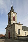
Church of the Nativity
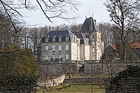
Échalot Castle

Wash-house in Lochère, former Saint-Roch chapel

Fallen memorial


Economy and Infrastructure
In the southeast, Échalot borders the site of the Valduc military nuclear research facility , which also produces nuclear weapons.
There are eight wind turbines to the west and southwest of the village of Échalot.
In Échalot there are nine agricultural (cultivation of grain, pulses and oilseeds) and two forestry businesses.
The D 19 trunk road from Billy-lès-Chanceaux to Salives runs through Échalot . In Til-Châtel , 25 kilometers south-east, there is a connection to the A 31 autoroute .
supporting documents
- ↑ Échalot on cassini.ehess.fr
- ↑ Échalot on insee.fr
- ↑ Farms on annuaire-mairie, fr
- ↑ Forestry in Échalot