Fontaines-en-Duesmois
| Fontaines-en-Duesmois | ||
|---|---|---|
|
|
||
| region | Bourgogne-Franche-Comté | |
| Department | Côte-d'Or | |
| Arrondissement | Montbard | |
| Canton | Châtillon-sur-Seine | |
| Community association | Pays Châtillonnais | |
| Coordinates | 47 ° 39 ′ N , 4 ° 33 ′ E | |
| height | 334-419 m | |
| surface | 17.9 km 2 | |
| Residents | 120 (January 1, 2017) | |
| Population density | 7 inhabitants / km 2 | |
| Post Code | 21450 | |
| INSEE code | 21276 | |
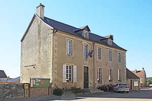
 Town hall (Mairie) of Fontaines-en-Duesmois |
||
Fontaines-en-Duesmois is a French municipality with 120 inhabitants (as of January 1, 2017) in the Côte-d'Or department in the region of Bourgogne Franche-Comté (before 2016 Bourgogne ); it belongs to the arrondissement of Montbard and the canton of Châtillon-sur-Seine (until 2015 Baigneux-les-Juifs ). The inhabitants are called Dubifontains .
geography
Fontaines-en-Duesmois is about 51 kilometers northwest of Dijon . Fontaines-en-Duesmois is surrounded by the neighboring communities of Villaines-en-Duesmois in the north, Magny-Lambert in the northeast, Chaume-lès-Baigneux in the east, Lucenay-le-Duc in the south and west and Touillon in the west.
Population development
| year | 1962 | 1968 | 1975 | 1982 | 1990 | 1999 | 2006 | 2013 |
| Residents | 198 | 175 | 171 | 134 | 124 | 126 | 143 | 125 |
| Source: Cassini and INSEE | ||||||||
Attractions
- Saint-Germain church, monument historique since 1927/2006
- Saint-Nicolas chapel from the 16th century, a historic monument since 1950
- Cistercian barn of Émorots, Monument historique since 2009
- 15th century manor house
Web links
Commons : Fontaines-en-Duesmois - collection of images, videos and audio files


