
Uncey-le-Franc
| Uncey-le-Franc | ||
|---|---|---|
|
||
| region | Bourgogne-Franche-Comté | |
| Department | Côte-d'Or | |
| Arrondissement | Montbard | |
| Canton | Semur-en-Auxois | |
| Community association | Terres d'Auxois | |
| Coordinates | 47 ° 21 ′ N , 4 ° 34 ′ E | |
| height | 344-539 m | |
| surface | 9.52 km 2 | |
| Residents | 54 (January 1, 2017) | |
| Population density | 6 inhabitants / km 2 | |
| Post Code | 21350 | |
| INSEE code | 21649 | |

Uncey-le-Franc is a French commune with a population of 54 (as at 1st January 2017) in the Côte-d'Or department in the region of Bourgogne Franche-Comté (before 2016 Burgundy ). It belongs to the arrondissement of Montbard and to the Terres d'Auxois community association founded in 2016 .
geography
Uncey-le-Franc is located in the Auxois region , about 40 kilometers west of Dijon on the Brenne , a tributary of the Armançon in the Yonne catchment area . The village of Uncey-le-Franc is located four kilometers below the dam of the Grosbois dam ( Barrage de Grosbois ). Uncey-le-Franc is surrounded by the neighboring municipalities of Saffres in the north, Avosnes in the northeast, Marcellois in the east, Grosbois-en-Montagne in the southeast, Premeaux-Prissey in the west and Nuits-Saint-Georges in the northwest.
The D 905 from Tonnerre leads through the municipality of Uncey-le-Franc to the Autoroute A 38 towards Dijon .
Population development
| year | 1962 | 1968 | 1975 | 1982 | 1990 | 1999 | 2006 | 2016 |
| Residents | 78 | 74 | 61 | 59 | 68 | 54 | 49 | 50 |
| Sources: Cassini and INSEE | ||||||||
Attractions
- Saint Martin Church
- Fallen memorial

Saint Martin Church
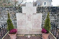
Fallen memorial


economy
Five farms are located in Uncey-le-Franc (cereal and vegetable growing, cattle breeding).