Vertault
| Vertault | ||
|---|---|---|
|
|
||
| region | Bourgogne-Franche-Comté | |
| Department | Côte-d'Or | |
| Arrondissement | Montbard | |
| Canton | Châtillon-sur-Seine | |
| Community association | Communauté de communes du Pays Châtillonnais | |
| Coordinates | 47 ° 55 ' N , 4 ° 21' E | |
| height | 187-303 m | |
| surface | 19.27 km 2 | |
| Residents | 56 (January 1, 2017) | |
| Population density | 3 inhabitants / km 2 | |
| Post Code | 21330 | |
| INSEE code | 21671 | |
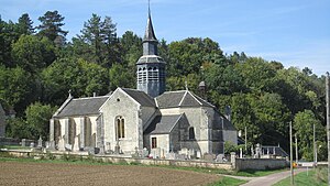
 Church in Vertault |
||
Vertault is a French municipality with 56 inhabitants (at January 1, 2017) in the department of Côte-d'Or in the region Bourgogne Franche-Comté . It belongs to the arrondissement of Montbard and the canton of Châtillon-sur-Seine .
Neighboring municipalities are Channes in the northwest, Bragelogne-Beauvoir in the north, Molesme in the northeast, Villedieu in the southeast and Channay in the south.
Population development
| year | 1962 | 1968 | 1975 | 1982 | 1990 | 1999 | 2008 | 2015 |
|---|---|---|---|---|---|---|---|---|
| Residents | 85 | 94 | 77 | 52 | 42 | 51 | 54 | 58 |
Attractions
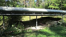
In ancient times, the Vertillum settlement was located in the vicinity of what would later become Vertault . This was proven during excavations in the 19th century. Among the numerous artifacts was the Vertault relief .

Remains of a Gallo-Roman bath from Vertillum
Web links
Commons : Vertault - collection of images, videos and audio files
