
Nesle-et-Massoult
| Nesle-et-Massoult | ||
|---|---|---|
|
||
| region | Bourgogne-Franche-Comté | |
| Department | Côte-d'Or | |
| Arrondissement | Montbard | |
| Canton | Montbard | |
| Community association | Montbardois | |
| Coordinates | 47 ° 47 ' N , 4 ° 26' E | |
| height | 238-317 m | |
| surface | 23.38 km 2 | |
| Residents | 75 (January 1, 2017) | |
| Population density | 3 inhabitants / km 2 | |
| Post Code | 21330 | |
| INSEE code | 21451 | |

Nesle-et-Massoult is a French commune with a population of 75 (as at 1st January 2017) in the Côte-d'Or department in the region of Bourgogne Franche-Comté . The municipality belongs to the arrondissement of Montbard and the canton of Montbard (until 2015: canton of Laignes ).
geography
Nesle-et-Massoult is about 68 kilometers north-west of Dijon and about 64 kilometers east of Auxerre am Laignes . Nesle-et-Massoult is surrounded by the neighboring communities of Balot in the north, Ampilly-le-Sec in the northeast, Coulmier-le-Sec in the east, Puits in the southeast, Savoisy in the south and southwest, Fontaines-les-Sèches in the west and Laignes in the Northwest.
Population development
| year | 1962 | 1968 | 1975 | 1982 | 1990 | 1999 | 2006 | 2013 |
| Residents | 134 | 122 | 99 | 80 | 92 | 101 | 89 | 78 |
| Source: Cassini and INSEE | ||||||||
Attractions
- Saint Martin Church
- Chapel of Sainte-Marie-Madeleine from the 12th century
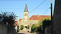
View of the Saint-Martin church

Sainte-Marie-Madeleine Chapel


Web links
Commons : Nesle-et-Massoult - collection of images, videos and audio files