La Roche-en-Brenil
| La Roche-en-Brenil | ||
|---|---|---|

|
|
|
| region | Bourgogne-Franche-Comté | |
| Department | Côte-d'Or | |
| Arrondissement | Montbard | |
| Canton | Semur-en-Auxois | |
| Community association | Saulieu | |
| Coordinates | 47 ° 23 ' N , 4 ° 11' E | |
| height | 273-573 m | |
| surface | 50.85 km 2 | |
| Residents | 869 (January 1, 2017) | |
| Population density | 17 inhabitants / km 2 | |
| Post Code | 21530 | |
| INSEE code | 21525 | |
| Website | http://www.la-roche-en-brenil.fr/ | |
La Roche-en-Brenil is a French municipality with 869 inhabitants (at January 1, 2017) in the Côte-d'Or department in the region of Bourgogne Franche-Comté (before 2016 Bourgogne ); it belongs to the arrondissement of Montbard and the canton of Semur-en-Auxois (until 2015 Saulieu ).
geography
La Roche-en-Brenil is about 58 kilometers west-northwest of Dijon in the Morvan . The municipality is crossed by the rivers Argentalet , Romanée and its tributary Tournesac . La Roche-en-Brenil is surrounded by the neighboring communities of Sincey-lès-Rouvray in the north and north-west, Montberthault and Courcelles-Frémoy in the north, Thoste in the north-east, Dompierre-en-Morvan and Lacour-d'Arcenay in the east, Molphey in the south-east , Saint-Didier in the south, Saint-Agnan in the south-west, Saint-Germain-de-Modéon in the west and Rouvray in the north-west.
Population development
| year | 1962 | 1968 | 1975 | 1982 | 1990 | 1999 | 2006 | 2011 | 2016 |
| Residents | 1,277 | 1,143 | 1,082 | 1,066 | 890 | 891 | 924 | 902 | 876 |
| Source: Cassini and INSEE | |||||||||
Attractions
- Saint-Alban Church
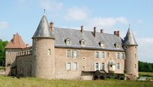
- La Roche Castle from the 12th century, rebuilt into a castle in the 16th century, monument historique since 1992

