
Clamerey
| Clamerey | ||
|---|---|---|
.svg)
|
|
|
| region | Bourgogne-Franche-Comté | |
| Department | Côte-d'Or | |
| Arrondissement | Montbard | |
| Canton | Semur-en-Auxois | |
| Community association | Terres d'Auxois | |
| Coordinates | 47 ° 23 ' N , 4 ° 26' E | |
| height | 314-491 m | |
| surface | 12.08 km 2 | |
| Residents | 184 (January 1, 2017) | |
| Population density | 15 inhabitants / km 2 | |
| Post Code | 21390 | |
| INSEE code | 21177 | |

Clamerey is a French municipality with 184 inhabitants (as of January 1 2017) in the Côte-d'Or department in the region of Bourgogne Franche-Comté . The municipality belongs to the arrondissement of Montbard and the canton of Semur-en-Auxois (until 2015: canton of Précy-sous-Thil ).
geography
Clamerey is located in the center of Burgundy in the Morvan . The village is located between the Armançon River and the Bourgogne Canal . Clamerey is surrounded by the neighboring communities of Braux in the north, Sainte-Colombe-en-Auxois in the northeast, Velogny in the east and northeast, Saint-Thibault in the east and southeast, Normier in the south and southeast, Charny in the south, Noidan in the south and southwest, Fontangy in the southwest, Nan-sous-Thil in the west and Marcigny-sous-Thil in the northwest.
Population development
| year | 1962 | 1968 | 1975 | 1982 | 1990 | 1999 | 2006 | 2013 |
| Residents | 271 | 258 | 220 | 217 | 193 | 191 | 175 | 182 |
| Source: Cassini and INSEE | ||||||||
Attractions
- Saint-Cyr-Sainte-Julitte church, monument historique since 1988
- Castle ruins of Lédavrée, monument historique since 1928
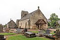
Saint-Cyr-Sainte-Julitte church
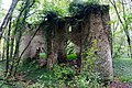
Lédavrée castle ruins

