
Dampierre-en-Montagne
| Dampierre-en-Montagne | ||
|---|---|---|
|
||
| region | Bourgogne-Franche-Comté | |
| Department | Côte-d'Or | |
| Arrondissement | Montbard | |
| Canton | Semur-en-Auxois | |
| Community association | Terres d'Auxois | |
| Coordinates | 47 ° 26 ' N , 4 ° 34' E | |
| height | 381-502 m | |
| surface | 10.36 km 2 | |
| Residents | 73 (January 1, 2017) | |
| Population density | 7 inhabitants / km 2 | |
| Post Code | 21350 | |
| INSEE code | 21224 | |
 Mairie Dampierre-en-Montagne |
||

Dampierre-en-Montagne is a French commune with a population of 73 (as at 1st January 2017) in the Côte-d'Or department in the region of Bourgogne Franche-Comté (before 2016 Burgundy ). It belongs to the arrondissement of Montbard and to the Terres d'Auxois community association founded in 2016 .
geography
Dampierre-en-Montagne is located in the Auxois countryside , about 42 kilometers northwest of Dijon at the source of the Ruisseau du Val Sambon , a tributary of the Ozerain in the Yonne basin . The municipal area of 10.36 km² encloses a high plateau at 450 to 500 m above sea level, which separates the river valleys of Ozerain and Brenne . Arable land predominates on the plateau, while the Chênuet forest extends to the north . Dampierre-en-Montagne is surrounded by the neighboring communities of Jailly-les-Moulins in the northeast, Villeberny in the east, Vitteaux in the south, Posanges in the southwest, Arnay-sous-Vitteaux in the west and Villeferry and La Roche-Vanneau in the northwest.
Place name
The names Dompierre and Dampierre indicate places with a Peterskirche (Saint-Pierre). With the addition of -en-Montagne one could translate the community name as St. Peter in the mountains . The place name appears for the first time in 1397 as Dompierre desur Viteaul . The name developed via Domperre (1449), Dampierre (1547), Demperre (1562) for the first time to Dampierre-en-Montagne (1574). After the spelling of Dampierre-lès-Vitteaux in 1757 and Dompierre-en-Montagne in 1783 , the Dampierre-en-Montagne form, which is still in use today, remained from 1801 .
Population development
| year | 1962 | 1968 | 1975 | 1982 | 1990 | 1999 | 2006 | 2016 |
| Residents | 72 | 71 | 68 | 66 | 56 | 68 | 72 | 76 |
| Sources: Cassini and INSEE | ||||||||
Attractions
- Saint-Pierre church
- two lavoirs
- multiple enclosed sources
- Croix des Vignes, monumental cross
- Fallen memorial
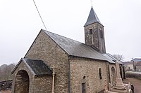
Saint-Pierre church

Fallen memorial


Economy and Infrastructure
Nine farms are located in Dampierre-en-Montagne (grain cultivation, cattle breeding).
The D117 road runs through Dampierre-en-Montagne from Posanges to Boux-sous-Salmaise . In Sombernon , 18 kilometers south-east, there is a connection to the Autoroute A 38 to Dijon .
supporting documents
- ↑ Place name JSTOR 23400429
- ↑ place name on cassini.ehess.fr
- ↑ Dampierre-en-Montagne on cassini.ehess.fr
- ↑ Dampierre-en-Montagne on insee.fr
- ↑ farms on annuaire-mairie.fr