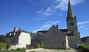
Gurgy-le-Château
| Gurgy-le-Château | ||
|---|---|---|

|
|
|
| region | Bourgogne-Franche-Comté | |
| Department | Côte-d'Or | |
| Arrondissement | Montbard | |
| Canton | Châtillon-sur-Seine | |
| Community association | Communauté de communes du Pays Châtillonnais | |
| Coordinates | 47 ° 50 ′ N , 4 ° 56 ′ E | |
| height | 307-440 m | |
| surface | 17.65 km 2 | |
| Residents | 44 (January 1, 2017) | |
| Population density | 2 inhabitants / km 2 | |
| Post Code | 21290 | |
| INSEE code | 21313 | |
Gurgey-le-Chateau is a French commune with 44 inhabitants (at January 1, 2017) in the department of Côte-d'Or in the region Bourgogne Franche-Comté . It belongs to the canton of Châtillon-sur-Seine and the arrondissement of Montbard .
Neighboring municipalities are Lucey in the northeast, Gurgy-la-Ville in the north, Rouvres-sur-Aube in the northeast, Arbot in the east, Buxerolles in the southeast, Chambain in the south and Faverolles-lès-Lucey in the southwest.
Population development
| year | 1962 | 1968 | 1975 | 1982 | 1990 | 1999 | 2008 | 2015 |
|---|---|---|---|---|---|---|---|---|
| Residents | 116 | 110 | 87 | 84 | 68 | 61 | 50 | 41 |
Web links
Commons : Gurgy-le-Château - Collection of images, videos and audio files


