
Vic-sous-Thil
| Vic-sous-Thil | ||
|---|---|---|
|
||
| region | Bourgogne-Franche-Comté | |
| Department | Côte-d'Or | |
| Arrondissement | Montbard | |
| Canton | Semur-en-Auxois | |
| Community association | Terres d'Auxois | |
| Coordinates | 47 ° 22 ′ N , 4 ° 19 ′ E | |
| height | 318-493 m | |
| surface | 21.34 km 2 | |
| Residents | 189 (January 1, 2017) | |
| Population density | 9 inhabitants / km 2 | |
| Post Code | 21390 | |
| INSEE code | 21678 | |

Vic-sous-Thil is a French municipality with 189 inhabitants (as of January 1 2017) in the Côte-d'Or department in the region of Bourgogne Franche-Comté . The municipality belongs to the arrondissement of Montbard and the canton of Semur-en-Auxois (until 2015: canton of Précy-sous-Thil ).
geography
Vic-sous-Thil is in the center of Burgundy in the Morvan on the Serein River . Vic-sous-Thil is surrounded by the neighboring municipalities of Précy-sous-Thil in the north, Nan-sous-Thil in the east, Fontangy in the southeast, La Motte-Ternant in the south, Montlay-en-Auxois in the southwest, Juillenay in the west and Aisy -sous-thil to the northwest.
Population development
| year | 1962 | 1968 | 1975 | 1982 | 1990 | 1999 | 2006 | 2013 |
| Residents | 250 | 233 | 203 | 208 | 209 | 203 | 205 | 196 |
| Source: Cassini and INSEE | ||||||||
Attractions
- Vic Collegiate Church, built between 1343 and 1350, Monument historique since 1905
- Castle from the 14th century, replacement building for the previous castle from the 10th / 11th. Century, Monument historique since 1905
- The "Manège", octagonal building for cattle breeding in Brouillard from the 19th century, Monument historique

Collegiate church

Castle
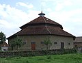
Octagonal building in Brouillard


Web links
Commons : Vic-sous-Thil - collection of images, videos and audio files