
Terrefondrée
| Terrefondrée | ||
|---|---|---|
.svg)
|
|
|
| region | Bourgogne-Franche-Comté | |
| Department | Côte-d'Or | |
| Arrondissement | Montbard | |
| Canton | Châtillon-sur-Seine | |
| Community association | Communauté de communes du Pays Châtillonnais | |
| Coordinates | 47 ° 44 ′ N , 4 ° 52 ′ E | |
| height | 307-452 m | |
| surface | 13.89 km 2 | |
| Residents | 62 (January 1, 2017) | |
| Population density | 4 inhabitants / km 2 | |
| Post Code | 21290 | |
| INSEE code | 21626 | |

Terrefondrée is a French municipality with 62 inhabitants (at January 1, 2017) in the department of Côte-d'Or in the region Bourgogne Franche-Comté . It belongs to the canton of Châtillon-sur-Seine and the arrondissement of Montbard .
It borders Recey-sur-Ource to the north, Bure-les-Templiers to the east, Saint-Broing-les-Moines to the south and Montmoyen to the west .
Population development
| year | 1962 | 1968 | 1975 | 1982 | 1990 | 1999 | 2008 | 2016 |
|---|---|---|---|---|---|---|---|---|
| Residents | 118 | 112 | 73 | 78 | 65 | 60 | 60 | 63 |
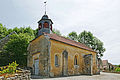
Chapel of Saint-Cyr de Châtellenot
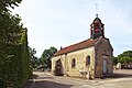
Saint-Louis de la Forêt chapel
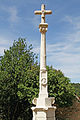
Romanesque floor cross in Châtellenot, Monument historique since 1926


Web links
Commons : Terrefondrée - collection of images, videos and audio files