
Noiron-sur-Seine
| Noiron-sur-Seine | ||
|---|---|---|
.svg)
|
|
|
| region | Bourgogne-Franche-Comté | |
| Department | Côte-d'Or | |
| Arrondissement | Montbard | |
| Canton | Châtillon-sur-Seine | |
| Community association | Pays Châtillonnais | |
| Coordinates | 47 ° 57 ' N , 4 ° 29' E | |
| height | 192-347 m | |
| surface | 11.38 km 2 | |
| Residents | 72 (January 1, 2017) | |
| Population density | 6 inhabitants / km 2 | |
| Post Code | 21400 | |
| INSEE code | 21460 | |
 View of Noiron-sur-Seine |
||

Noiron-sur-Seine is a French commune with a population of 72 (as at 1st January 2017) in the Côte-d'Or department in the region of Bourgogne Franche-Comté (before 2016 Burgundy ). It belongs to the arrondissement of Montbard and the commune association Pays Châtillonnais, founded in 2003 .
geography
Noiron-sur-Seine is located in the north of the Côte-d'Or department, near the border with the Aube department and the Grand Est region , about 55 kilometers southeast of Troyes and 95 kilometers northwest of Dijon . The eastern border of the 11.38 km² large municipal area is marked by the upper reaches of the Seine . The village of Noiron is about two kilometers from the banks of the Seine in a side valley created by the La Noue Rot stream . Apart from the section between the village of Noiron and the banks of the Seine, the rest of the municipality (over 80%) is covered by forest; the Forêt Domaniale de Charme Boullerain - in parts designated as a nature reserve - is only part of a much larger forest area that extends a further seven kilometers to the north and ten kilometers to the southwest. A special feature are three clearing islands in the forest, which are planted with vines as slopes sloping to the south and east. Although located far north of the contiguous wine-growing region of Burgundy , the municipality's winemakers are allowed to market their wines as Crémant de Bourgogne , Bourgogne Aligoté and Bourgogne Grand Ordinaire . Noiron-sur-Seine is surrounded by the neighboring communities of Gomméville in the north, Charrey-sur-Seine in the east, Pothières in the south and Bouix in the west.
Population development
| year | 1962 | 1968 | 1975 | 1982 | 1990 | 1999 | 2009 | 2016 |
| Residents | 147 | 131 | 114 | 109 | 98 | 91 | 82 | 76 |
| Sources: Cassini and INSEE | ||||||||
Attractions
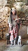
- Saint-Pierre church from the 15th century, monument historique
- Town hall and school building ( mairie-école ) from 1859, Monument historique
- Lavoir
- three hall crosses
- Saint-Pierre church


Economy and Infrastructure
In Noiron-sur-Seine there are several farms (viticulture, pig breeding) and a forestry company.
Noiron-sur-Seine can only be reached from the Seine valley, from the north via Gomméville and from the south via Charrey-sur-Seine . In Beurey , 33 kilometers northeast, there is a connection to the A 5 autoroute from Troyes to Langres .
supporting documents
- ↑ Noiron-sur-Seine on cassini.ehess.fr
- ↑ Noiron-sur-Seine on insee.fr
- ^ Entry in the Base Mérimée of the Ministry of Culture. Retrieved February 9, 2019 (French).
- ^ Entry in the Base Mérimée of the Ministry of Culture. Retrieved February 9, 2019 (French).
- ↑ Farms on annuaire-mairie, fr